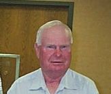
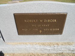
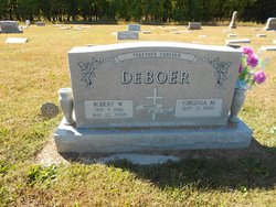
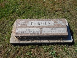
Robert Wayne “Bob” De Boer
| Birth | : | 9 Nov 1936 Firth, Lancaster County, Nebraska, USA |
| Death | : | 22 May 2008 Holland, Lancaster County, Nebraska, USA |
| Burial | : | Holland Cemetery, Holland, Lancaster County, USA |
| Coordinate | : | 40.5957985, -96.5997009 |
| Plot | : | West half of cemetery, Lot 69, Row 4, Block 2. 4th row from gate |
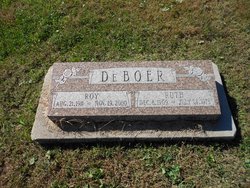
| Description | : | Thanks to contributor #47910340 Robert Wayne Bob DeBoer, 71, Holland, died Thursday, May 22, 2008 at his home. Born November 9, 1936, Firth, to Roy and Ruth (Devries) DeBoer. United States Army veteran. Lifelong farmer, Holland area. Member, Holland Reformed Church, where Bob taught Sunday School and held several church offices; Gideons. Survivors: wife, Virginia; sons and daughters-in-law, Steve and Dena DeBoer, Firh; Mike and Amber DeBoer, Bailey, Colorado; daughters and sons-in-law, Kathi and Scott Wieskamp, Panama; Kristi and Jerry TeKolste, Firth; eight grandchildren; brothers and sisters-in-law, Bruce and Susan DeBoer, Denver, Colorado; Gary and Kathy... Read More |
frequently asked questions (FAQ):
-
Where is Robert Wayne “Bob” De Boer's memorial?
Robert Wayne “Bob” De Boer's memorial is located at: Holland Cemetery, Holland, Lancaster County, USA.
-
When did Robert Wayne “Bob” De Boer death?
Robert Wayne “Bob” De Boer death on 22 May 2008 in Holland, Lancaster County, Nebraska, USA
-
Where are the coordinates of the Robert Wayne “Bob” De Boer's memorial?
Latitude: 40.5957985
Longitude: -96.5997009
Family Members:
Parent
Spouse
Flowers:
Nearby Cemetories:
1. Holland Cemetery
Holland, Lancaster County, USA
Coordinate: 40.5957985, -96.5997009
2. Swiggart Family Cemetery
Hickman, Lancaster County, USA
Coordinate: 40.6181060, -96.5909170
3. Hickman Cemetery
Hickman, Lancaster County, USA
Coordinate: 40.6210861, -96.6292496
4. Stagecoach Lake Cemetery
Hickman, Lancaster County, USA
Coordinate: 40.6028830, -96.6447370
5. Dietz Cemetery
Firth, Lancaster County, USA
Coordinate: 40.5449982, -96.6286011
6. Panama Cemetery
Panama, Lancaster County, USA
Coordinate: 40.5821991, -96.5255966
7. Firth Cemetery
Firth, Lancaster County, USA
Coordinate: 40.5250015, -96.6085968
8. Roca Cemetery
Roca, Lancaster County, USA
Coordinate: 40.6581039, -96.6499710
9. Stockfeldt Cemetery
Sprague, Lancaster County, USA
Coordinate: 40.6116982, -96.7080994
10. Pella Cemetery
Panama, Lancaster County, USA
Coordinate: 40.5555992, -96.5014038
11. Princeton Cemetery
Princeton, Lancaster County, USA
Coordinate: 40.5668983, -96.7052994
12. Saint Johns Lutheran Cemetery
Cortland, Gage County, USA
Coordinate: 40.5078300, -96.6252700
13. Bennet Cemetery
Bennet, Lancaster County, USA
Coordinate: 40.6889572, -96.5079193
14. Solon Cemetery
Otoe County, USA
Coordinate: 40.5917015, -96.4436035
15. Mount Zion Cemetery
Otoe County, USA
Coordinate: 40.6250000, -96.4449997
16. Sunnyside Cemetery
Cortland, Gage County, USA
Coordinate: 40.4799200, -96.6511800
17. Hallam Zion Cemetery
Hallam, Lancaster County, USA
Coordinate: 40.5661011, -96.7600021
18. Centerville Cemetery
Centerville, Lancaster County, USA
Coordinate: 40.6545677, -96.7482147
19. Simmons-Saltillo Cemetery
Lincoln, Lancaster County, USA
Coordinate: 40.7113991, -96.6735992
20. Cheney Cemetery
Cheney, Lancaster County, USA
Coordinate: 40.7257996, -96.6066971
21. Saint James Cemetery
Cortland, Gage County, USA
Coordinate: 40.4886050, -96.7036050
22. Cortland Cemetery
Cortland, Gage County, USA
Coordinate: 40.4879200, -96.7041250
23. Grandview Cemetery
Gage County, USA
Coordinate: 40.4617004, -96.6091995
24. Latrobe Cemetery
Sterling, Johnson County, USA
Coordinate: 40.5151000, -96.4557000

