
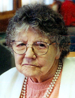

Roberta Pearl Mintz Trammell
| Birth | : | 29 Nov 1914 Canehill, Washington County, Arkansas, USA |
| Death | : | 23 Sep 2007 Parsons, Labette County, Kansas, USA |
| Burial | : | Walhallow Cemetery, Caroona, Liverpool Plains Shire, Australia |
| Coordinate | : | -31.4029460, 150.4242460 |
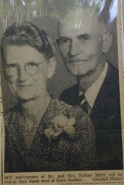
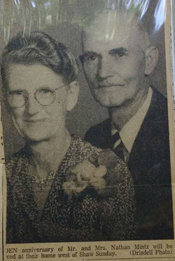
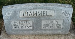
| Description | : | Roberta Trammell Roberta Trammell, former longtime Erie resident, died at 11:55 a.m. Sunday, Sept. 23, 2007, at the Good Samaritan Society of Parsons, where she had resided the past several years. She was born Nov. 29, 1914, at Cane Hill, Ark., to Nathan and Nellie (Hembree) Mintz. The family moved to the Big Creek area near Chanute when she was 10 years old. On Feb. 21, 1937, she married Loren C. Trammell in Chanute. After their marriage they lived on a farm near Odense until 1944, when they moved to Erie. Mr. Trammell preceded her in death on May 26, 1978. Mrs. Trammell... Read More |
frequently asked questions (FAQ):
-
Where is Roberta Pearl Mintz Trammell's memorial?
Roberta Pearl Mintz Trammell's memorial is located at: Walhallow Cemetery, Caroona, Liverpool Plains Shire, Australia.
-
When did Roberta Pearl Mintz Trammell death?
Roberta Pearl Mintz Trammell death on 23 Sep 2007 in Parsons, Labette County, Kansas, USA
-
Where are the coordinates of the Roberta Pearl Mintz Trammell's memorial?
Latitude: -31.4029460
Longitude: 150.4242460
Family Members:
Parent
Spouse
Siblings
Children
Flowers:


Nearby Cemetories:
1. Walhallow Cemetery
Caroona, Liverpool Plains Shire, Australia
Coordinate: -31.4029460, 150.4242460
2. Spring Ridge Cemetery
Spring Ridge, Liverpool Plains Shire, Australia
Coordinate: -31.3874828, 150.2835445
3. Breeza General Cemetery
Breeza, Gunnedah Shire, Australia
Coordinate: -31.2498300, 150.4610290
4. Quipolly General Cemetery
Quipolly, Liverpool Plains Shire, Australia
Coordinate: -31.4480100, 150.6145450
5. Werris Creek General Cemetery
Werris Creek, Liverpool Plains Shire, Australia
Coordinate: -31.3342800, 150.6535400
6. Old Quirindi Burial Ground (Defunct)
Quirindi, Liverpool Plains Shire, Australia
Coordinate: -31.5177689, 150.6779610
7. Colly Blue Cemetery
Colly Blue, Liverpool Plains Shire, Australia
Coordinate: -31.4579540, 150.1393320
8. Quirindi General Cemetery
Quirindi, Liverpool Plains Shire, Australia
Coordinate: -31.5182600, 150.6869300
9. Quirindi Lawn Cemetery
Quirindi, Liverpool Plains Shire, Australia
Coordinate: -31.5182600, 150.6869300
10. Blackville Catholic Cemetery
Blackville, Liverpool Plains Shire, Australia
Coordinate: -31.6440290, 150.2371790
11. Curlewis Cemetery
Curlewis, Gunnedah Shire, Australia
Coordinate: -31.1268010, 150.2691040
12. Currabubula Cemetery
Currabubula, Liverpool Plains Shire, Australia
Coordinate: -31.2639201, 150.7484767
13. Willow Tree Cemetery
Willow Tree, Liverpool Plains Shire, Australia
Coordinate: -31.6533740, 150.7283810
14. Willow Tree Catholic Cemetery
Willow Tree, Liverpool Plains Shire, Australia
Coordinate: -31.6646200, 150.7267100
15. Wallabadah General Cemetery
Wallabadah, Liverpool Plains Shire, Australia
Coordinate: -31.5463600, 150.8253800
16. Carroll General Cemetery
Carroll, Gunnedah Shire, Australia
Coordinate: -30.9947500, 150.4495200
17. Gunnedah Memorial Park
Gunnedah, Gunnedah Shire, Australia
Coordinate: -30.9929200, 150.2320660
18. Sisters of Mercy Cemetery
Gunnedah, Gunnedah Shire, Australia
Coordinate: -30.9805057, 150.2607847
19. Gunnedah General Cemetery
Gunnedah, Gunnedah Shire, Australia
Coordinate: -30.9840660, 150.2425840
20. Tambar Springs General Cemetery
Tambar Springs, Gunnedah Shire, Australia
Coordinate: -31.3436510, 149.8417510
21. Boggabri General Cemetery
Boggabri, Narrabri Shire, Australia
Coordinate: -30.7060570, 150.0366360
22. Gins Leap Cemetery
Boggabri, Narrabri Shire, Australia
Coordinate: -30.6556150, 150.0412450
23. Wybong Cemetery
Wybong, Muswellbrook Shire, Australia
Coordinate: -32.2771470, 150.6375970
24. Giants Creek Cemetery
Sandy Hollow, Muswellbrook Shire, Australia
Coordinate: -32.3249630, 150.5482480