| Birth | : | 14 Mar 1945 Jennings, Decatur County, Kansas, USA |
| Death | : | 23 Dec 2011 Topeka, Shawnee County, Kansas, USA |
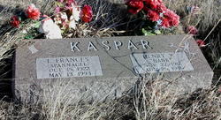
| Burial | : | Sunnyslope Memorial Gardens, Council Grove, Morris County, USA |
| Coordinate | : | 38.6796700, -96.4644400 |
| Plot | : | South section/2nd row from west |
| Inscription | : | Married July 26, 2003 |
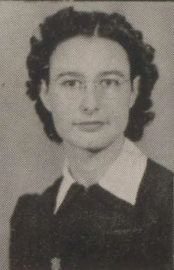
| Description | : | Robin (Rob) D. Kaspar, 66, of Council Grove passed away Dec. 23, 2011 at Stormont-Vail Hospital in Topeka, KS. He was born March 14, 1945 to Henry and Francis (Spannagel) Kaspar of Jennings, KS. He graduated from Dresden High School in Dresden, KS. He served in the US Army and did a tour in the Vietnam War from Jan 1966- Jan 1968. From 1970-1975 he and his brother, Jim Kaspar, owned and ran the old Beto Junction Station. Rob worked for KDOT beginning at Hoxie, KS in 1977. He transferred to Council Grove in 1980 and retired in 2002.... Read More |
frequently asked questions (FAQ):
-
Where is Robin D. “Rob” Kaspar's memorial?
Robin D. “Rob” Kaspar's memorial is located at: Sunnyslope Memorial Gardens, Council Grove, Morris County, USA.
-
When did Robin D. “Rob” Kaspar death?
Robin D. “Rob” Kaspar death on 23 Dec 2011 in Topeka, Shawnee County, Kansas, USA
-
Where are the coordinates of the Robin D. “Rob” Kaspar's memorial?
Latitude: 38.6796700
Longitude: -96.4644400
Family Members:
Parent
Siblings
Flowers:
Nearby Cemetories:
1. Sunnyslope Memorial Gardens
Council Grove, Morris County, USA
Coordinate: 38.6796700, -96.4644400
2. Greenwood Cemetery
Council Grove, Morris County, USA
Coordinate: 38.6581900, -96.5010900
3. Calvary Cemetery
Council Grove, Morris County, USA
Coordinate: 38.6567001, -96.5111008
4. Little John Cemetery
Council Grove, Morris County, USA
Coordinate: 38.6568300, -96.4175100
5. Hebrank Cemetery
Council Grove, Morris County, USA
Coordinate: 38.7172000, -96.4260100
6. Raglan Cemetery
Dunlap, Morris County, USA
Coordinate: 38.6370100, -96.3942700
7. Four Mile Cemetery
Council Grove, Morris County, USA
Coordinate: 38.6086200, -96.5097000
8. Comiskey Cemetery
Morris County, USA
Coordinate: 38.6521988, -96.3535995
9. Gilbert Family Cemetery
Bushong, Lyon County, USA
Coordinate: 38.6895800, -96.3458500
10. Garfield Cemetery
Morris County, USA
Coordinate: 38.7817001, -96.4591980
11. Kelso Cemetery
Parkerville, Morris County, USA
Coordinate: 38.7496986, -96.5714035
12. Downing Cemetery
Kelso, Morris County, USA
Coordinate: 38.7467650, -96.5851850
13. Dunlap Colored Cemetery
Dunlap, Morris County, USA
Coordinate: 38.5875015, -96.3538971
14. Pleasant View Cemetery
Council Grove, Morris County, USA
Coordinate: 38.5948000, -96.5880700
15. Beman Cemetery
Morris County, USA
Coordinate: 38.8072014, -96.4266968
16. Dunlap Cemetery
Dunlap, Morris County, USA
Coordinate: 38.5792007, -96.3538971
17. Agnes City Cemetery
Bushong, Lyon County, USA
Coordinate: 38.6880989, -96.2799988
18. Prairie View Cemetery
Wabaunsee County, USA
Coordinate: 38.8114014, -96.3696976
19. Exon Family Cemetery
Eskridge, Wabaunsee County, USA
Coordinate: 38.7595800, -96.2988400
20. Pleasant Ridge Cemetery
Wabaunsee County, USA
Coordinate: 38.7969017, -96.3347015
21. Sunnyside Cemetery
Bushong, Lyon County, USA
Coordinate: 38.6083900, -96.2853700
22. Henry Clousing Burial Site
Bushong, Lyon County, USA
Coordinate: 38.6954800, -96.2608700
23. Chalk Cemetery
Wabaunsee County, USA
Coordinate: 38.7675018, -96.2910995
24. Highland Cemetery
Wilsey, Morris County, USA
Coordinate: 38.6678009, -96.6716995


