
| Birth | : | 18 Jan 1920 Manville, Niobrara County, Wyoming, USA |
| Death | : | 30 Oct 1997 Fredonia, Wilson County, Kansas, USA |
| Burial | : | Riverview Cemetery, Knox County, USA |
| Coordinate | : | 42.7322006, -98.1619034 |
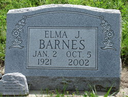
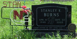
| Description | : | Married: 1) Elma J. Knutson, 22 Jun 1940 Yankton, SD, (Later Divorced). 2) Elna Louise (Olson) Chase Roger "Bud" Clark Burns, 77, a resident of Fredonia, Kansas, died Thursday, Oct. 30, 1997, at Beverly Health and Rehabilitation in Fredonia. He was born in Manville, Wyoming on January 18, 1920, to Royal Samual and Gussie Pauline (Rogers) Burns. He was a retired truck driver and farmer. He married Elna Olson, and she survives at home. Other survivors are nine children, Roger E. Burns of Essex, Iowa, Lonnie Burns of Hoskins, Nebraska, Stanley Burns of Socurro, New Mexico, Myrna Vonasek of Verdigre, Nebraska, Susan Burns of Arizona City, Arizona,... Read More |
frequently asked questions (FAQ):
-
Where is Roger Clark “Bud” Burns's memorial?
Roger Clark “Bud” Burns's memorial is located at: Riverview Cemetery, Knox County, USA.
-
When did Roger Clark “Bud” Burns death?
Roger Clark “Bud” Burns death on 30 Oct 1997 in Fredonia, Wilson County, Kansas, USA
-
Where are the coordinates of the Roger Clark “Bud” Burns's memorial?
Latitude: 42.7322006
Longitude: -98.1619034
Family Members:
Parent
Spouse
Children

Flowers:


Nearby Cemetories:
1. Riverview Cemetery
Knox County, USA
Coordinate: 42.7322006, -98.1619034
2. Ponca Evangelical Lutheran Cemetery
Niobrara, Knox County, USA
Coordinate: 42.7428000, -98.1621000
3. Kurka Family Cemetery
Dukesville, Knox County, USA
Coordinate: 42.6918000, -98.1374000
4. Pleasant Hill Cemetery
Verdigre, Knox County, USA
Coordinate: 42.6837500, -98.1619500
5. Ponka Tribal Cemetery
Knox County, USA
Coordinate: 42.7122700, -98.0830000
6. National Cemetery
Pishelville, Knox County, USA
Coordinate: 42.7190000, -98.2500000
7. Mormon Monument
Ponca, Knox County, USA
Coordinate: 42.7443000, -98.0632500
8. Ponca Valley Cemetery
Verdel, Knox County, USA
Coordinate: 42.8135000, -98.1990000
9. L'Eau Qui Court Cemetery
Niobrara, Knox County, USA
Coordinate: 42.7458000, -98.0231018
10. Bohemian National Cemetery
Knox County, USA
Coordinate: 42.6178017, -98.1483002
11. Riha Cemetery
Verdel, Knox County, USA
Coordinate: 42.7930000, -98.3086000
12. Ruth Cemetery
Knoxville, Knox County, USA
Coordinate: 42.6256000, -98.2597500
13. Hillcrest Cemetery
Verdigre, Knox County, USA
Coordinate: 42.6356010, -98.0378036
14. Dorsey Cemetery
Holt County, USA
Coordinate: 42.6755981, -98.3339005
15. Pioneer Cemetery
Springfield, Bon Homme County, USA
Coordinate: 42.8513985, -98.0500031
16. Alford Cemetery
Monowi, Boyd County, USA
Coordinate: 42.7997017, -98.3450012
17. Saint Wenceslaus Cemetery
Verdigre, Knox County, USA
Coordinate: 42.6039009, -98.0428009
18. Old Holy Name Cemetery
Dante, Charles Mix County, USA
Coordinate: 42.8868700, -98.2032900
19. Star Cemetery
Holt County, USA
Coordinate: 42.6408005, -98.3435974
20. Bethlehem Lutheran Cemetery
Springfield, Bon Homme County, USA
Coordinate: 42.8727989, -98.0494003
21. Riverside Cemetery
Verdigre, Knox County, USA
Coordinate: 42.6011009, -98.0286026
22. Pleasant Valley Cemetery
Verdigre, Knox County, USA
Coordinate: 42.5678900, -98.1491800
23. Emanuel Cemetery
Springfield, Bon Homme County, USA
Coordinate: 42.8400002, -97.9903030
24. Bazile Creek Cemetery
Bazile Mills, Knox County, USA
Coordinate: 42.7377500, -97.9311500