
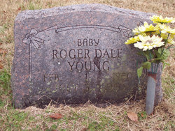
Roger Dale Young
| Birth | : | 1 Feb 1950 Thayer, Oregon County, Missouri, USA |
| Death | : | 3 Jul 1950 Myrtle, Oregon County, Missouri, USA |
| Burial | : | Sunset Memorial Gardens, Minot, Ward County, USA |
| Coordinate | : | 48.2997017, -101.2977982 |
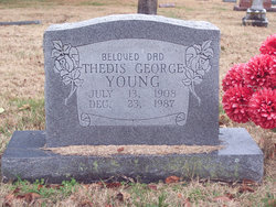
| Description | : | Infant son of Thedis George Young and Jessie Mary (McGehee) Young. Per MO Death certificate #24188, burial 05/Jul/1950. |
frequently asked questions (FAQ):
-
Where is Roger Dale Young's memorial?
Roger Dale Young's memorial is located at: Sunset Memorial Gardens, Minot, Ward County, USA.
-
When did Roger Dale Young death?
Roger Dale Young death on 3 Jul 1950 in Myrtle, Oregon County, Missouri, USA
-
Where are the coordinates of the Roger Dale Young's memorial?
Latitude: 48.2997017
Longitude: -101.2977982
Family Members:
Parent
Siblings


Nearby Cemetories:
1. Sunset Memorial Gardens
Minot, Ward County, USA
Coordinate: 48.2997017, -101.2977982
2. Grueneberg Family Cemetery
Minot, Ward County, USA
Coordinate: 48.3268600, -101.3450600
3. Trinity Lutheran Cemetery
Minot, Ward County, USA
Coordinate: 48.3408051, -101.2533188
4. First Lutheran Church Cemetery
Minot, Ward County, USA
Coordinate: 48.2470000, -101.2964000
5. Zion Lutheran Cemetery (Defunct)
Minot, Ward County, USA
Coordinate: 48.2471500, -101.3111600
6. Hebrew Cemetery
Minot, Ward County, USA
Coordinate: 48.2467400, -101.3119500
7. Rosehill Memorial Park
Minot, Ward County, USA
Coordinate: 48.2238998, -101.2866974
8. Wolff Family Cemetery
Ruthville, Ward County, USA
Coordinate: 48.3557300, -101.3768800
9. Emmanuel Lutheran Cemetery
Ruthville, Ward County, USA
Coordinate: 48.3562851, -101.3823090
10. Burlington Township Cemetery
Burlington, Ward County, USA
Coordinate: 48.2817421, -101.4292679
11. Immanuel Lutheran Cemetery
Surrey, Ward County, USA
Coordinate: 48.3275681, -101.1432495
12. Old German Baptist Cemetery
Surrey, Ward County, USA
Coordinate: 48.2979758, -101.1226340
13. Prairie Peace Fellowship Cemetery
Surrey, Ward County, USA
Coordinate: 48.2419472, -101.1341858
14. Lynch Immanuel Lutheran Church Cemetery
Ward County, USA
Coordinate: 48.4293213, -101.3009720
15. Bethany Lutheran Cemetery
Minot, Ward County, USA
Coordinate: 48.4294000, -101.2133000
16. Fairview Mennonite Cemetery
Surrey, Ward County, USA
Coordinate: 48.2107760, -101.1294940
17. Larson Gravesite
Ward County, USA
Coordinate: 48.2700000, -101.5200000
18. Burlington Township Cemetery
Des Lacs, Ward County, USA
Coordinate: 48.2452545, -101.5128174
19. Drady Cemetery
Minot, Ward County, USA
Coordinate: 48.1538048, -101.4261169
20. Saint Marys Cemetery
Foxholm, Ward County, USA
Coordinate: 48.3717003, -101.5556030
21. Des Lacs Cemetery
Des Lacs, Ward County, USA
Coordinate: 48.2574997, -101.5749969
22. Deering Lutheran Cemetery
Deering, McHenry County, USA
Coordinate: 48.3861000, -101.0322000
23. Nidaros Lutheran Cemetery
Wolseth, Ward County, USA
Coordinate: 48.4438000, -101.0962000
24. Township Cemetery
Ward County, USA
Coordinate: 48.1847000, -101.5472031