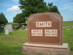
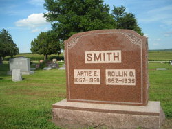
Rollin O. Smith
| Birth | : | 27 Apr 1852 Geneva, Ontario County, New York, USA |
| Death | : | 4 Sep 1935 Emerson, Mills County, Iowa, USA |
| Burial | : | Bayview Memorial Park, Pensacola, Escambia County, USA |
| Coordinate | : | 30.4550900, -87.1727400 |
| Plot | : | 1st Addition #129 |
| Description | : | R. O. SMITH DIED IN EMERSON LAST TUESDAY, SEPTEMBER 4 HAD LIVED THERE 41 YEEARS FUNERAL HELD FRIDAY AFTERNOON Funeral services were held in the Methodist Church in Emerson Friday afternoon at 2:30 o'clock conducted by the pastor, Ref. I. E. Ripley, assisted by Jas P. Stille, pastor of the Baptist Church. Music was furnished by Mrs. Clara Thorson, Mrs. Louise Whisler, Robert Honeyman, and J. N. Cheney. Mr. Honeyman sang a solo, "Sweet Home of Rest." The flowers were in charge of Irene Crofton, Evangeline Lang, and Isa Barns, and were profuse and beautiful. Burial was in the Emerson... Read More |
frequently asked questions (FAQ):
-
Where is Rollin O. Smith's memorial?
Rollin O. Smith's memorial is located at: Bayview Memorial Park, Pensacola, Escambia County, USA.
-
When did Rollin O. Smith death?
Rollin O. Smith death on 4 Sep 1935 in Emerson, Mills County, Iowa, USA
-
Where are the coordinates of the Rollin O. Smith's memorial?
Latitude: 30.4550900
Longitude: -87.1727400
Family Members:
Parent
Spouse
Siblings
Children
Flowers:
Nearby Cemetories:
1. Bayview Memorial Park
Pensacola, Escambia County, USA
Coordinate: 30.4550900, -87.1727400
2. New Hope Cemetery
Pensacola, Escambia County, USA
Coordinate: 30.4609000, -87.1720900
3. Trinity Presbyterian Church Memorial Gardens
Pensacola, Escambia County, USA
Coordinate: 30.4570200, -87.1965900
4. Holy Cross Catholic Cemetery
Pensacola, Escambia County, USA
Coordinate: 30.4460600, -87.2059500
5. Saint Christophers Memorial Garden
Escambia County, USA
Coordinate: 30.4470200, -87.2073200
6. Saint Paul's All Saints Memorial Garden
Pensacola, Escambia County, USA
Coordinate: 30.4651200, -87.2135200
7. Montgomery-John The Baptist Cemetery
Pensacola, Escambia County, USA
Coordinate: 30.4410900, -87.2124300
8. Miraflores Park
Pensacola, Escambia County, USA
Coordinate: 30.4216328, -87.1952129
9. Roberts Cemetery
Pensacola, Escambia County, USA
Coordinate: 30.4981003, -87.1791992
10. Mount Zion Historical Cemetery
Pensacola, Escambia County, USA
Coordinate: 30.4388466, -87.2202988
11. Clopton Cemetery
Pensacola, Escambia County, USA
Coordinate: 30.4686775, -87.2262192
12. Saint Michael's Cemetery
Pensacola, Escambia County, USA
Coordinate: 30.4141998, -87.2091980
13. Old Pensacola Fort Burial Ground
Pensacola, Escambia County, USA
Coordinate: 30.4186990, -87.2169290
14. First United Methodist Church Columbarium
Pensacola, Escambia County, USA
Coordinate: 30.4168500, -87.2158200
15. Holy Cross Episcopal Church Columbarium
Pensacola, Escambia County, USA
Coordinate: 30.5075410, -87.1848880
16. Christ Episcopal Church Columbarium
Pensacola, Escambia County, USA
Coordinate: 30.4171900, -87.2166500
17. First Presbyterian Church Columbarium
Pensacola, Escambia County, USA
Coordinate: 30.4145400, -87.2153900
18. Horton Memorial Garden
Pensacola, Escambia County, USA
Coordinate: 30.4719200, -87.2332580
19. Potters Field Cemetery
Pensacola, Escambia County, USA
Coordinate: 30.4395800, -87.2338000
20. Magnolia Cemetery
Pensacola, Escambia County, USA
Coordinate: 30.4246040, -87.2258660
21. Magnolia Cemetery #2
Escambia County, USA
Coordinate: 30.4371700, -87.2336900
22. Zion Cemetery
Pensacola, Escambia County, USA
Coordinate: 30.4234600, -87.2260400
23. Tippin-Walton Cemetery
Ferry Pass, Escambia County, USA
Coordinate: 30.5124000, -87.1954000
24. Panton House Burial Site
Pensacola, Escambia County, USA
Coordinate: 30.4071500, -87.2173500

