
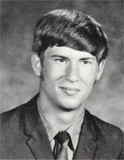

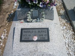
Ronald D “Ron” Blake
| Birth | : | 19 Oct 1955 Parsons, Labette County, Kansas, USA |
| Death | : | 27 Jun 2010 Parsons, Labette County, Kansas, USA |
| Burial | : | Rollag Lutheran Cemetery, Rollag, Clay County, USA |
| Coordinate | : | 46.7401000, -96.2386200 |
| Plot | : | Section 9, Row 5, Lot 117 |
| Description | : | Ronald D. "Ron" Blake, 54, of Parsons, was pronounced dead on Sunday afternoon at his home. His death was unexpected. He was born on October 19, 1955 at Parsons to Robert F. and Lois L. (McMillan) Blake. He grew up at Parsons and attended Parsons schools graduating from Parsons High School in 1973. He worked at C & M Motors in Independence for many years as a mechanic. He was baptized at the St. John's Episcopal Church in Parsons. He was member of the Parsons Elks Lodge No. 527 in Parsons. He enjoyed spending time with his family and... Read More |
frequently asked questions (FAQ):
-
Where is Ronald D “Ron” Blake's memorial?
Ronald D “Ron” Blake's memorial is located at: Rollag Lutheran Cemetery, Rollag, Clay County, USA.
-
When did Ronald D “Ron” Blake death?
Ronald D “Ron” Blake death on 27 Jun 2010 in Parsons, Labette County, Kansas, USA
-
Where are the coordinates of the Ronald D “Ron” Blake's memorial?
Latitude: 46.7401000
Longitude: -96.2386200
Family Members:
Parent
Children
Flowers:


Nearby Cemetories:
1. Rollag Lutheran Cemetery
Rollag, Clay County, USA
Coordinate: 46.7401000, -96.2386200
2. Grong Cemetery
Rollag, Clay County, USA
Coordinate: 46.7434196, -96.2380142
3. Yankee Cemetery
Parke Township, Clay County, USA
Coordinate: 46.7468080, -96.2163140
4. Bethany Cemetery
Parke Township, Clay County, USA
Coordinate: 46.7388889, -96.1958333
5. Park Lutheran Church Cemetery
Parke Township, Clay County, USA
Coordinate: 46.7762430, -96.1875070
6. Gran Lutheran Church Cemetery
Skree Township, Clay County, USA
Coordinate: 46.7179310, -96.3205290
7. Aspelund Cemetery
Tansem Township, Clay County, USA
Coordinate: 46.6753006, -96.2367020
8. Lake Ida Cemetery
Cormorant Township, Becker County, USA
Coordinate: 46.7401700, -96.1233100
9. Cormorant Lutheran Cemetery
Cormorant Township, Becker County, USA
Coordinate: 46.7436800, -96.1088300
10. Zion Lutheran Cemetery
Skree Township, Clay County, USA
Coordinate: 46.7722015, -96.3656006
11. Solem Cemetery
Eglon Township, Clay County, USA
Coordinate: 46.8344800, -96.2191200
12. Hegland Cemetery
Eglon Township, Clay County, USA
Coordinate: 46.8345604, -96.2715759
13. Houglum Cemetery
Lake Park Township, Becker County, USA
Coordinate: 46.8317900, -96.1602900
14. Grove Lake Church Cemetery
Pelican Rapids, Otter Tail County, USA
Coordinate: 46.6448330, -96.1302210
15. Silver Lake Pioneer Cemetery
Hawley Township, Clay County, USA
Coordinate: 46.8339005, -96.3503036
16. Norwegian Cemetery
Humboldt Township, Clay County, USA
Coordinate: 46.6747017, -96.3899994
17. West North Immanuel Church Cemetery
Norwegian Grove, Otter Tail County, USA
Coordinate: 46.6166992, -96.2253036
18. Little Bethany Church Cemetery
Norwegian Grove, Otter Tail County, USA
Coordinate: 46.6196660, -96.2806500
19. Scambler Cemetery
Pelican Rapids, Otter Tail County, USA
Coordinate: 46.6556015, -96.0999985
20. Grove Lake South Cemetery
Pelican Rapids, Otter Tail County, USA
Coordinate: 46.6343994, -96.1294022
21. North Immanuel Cemetery
Norwegian Grove, Otter Tail County, USA
Coordinate: 46.6093300, -96.2139600
22. Strandvik Lutheran Cemetery
Lake Park Township, Becker County, USA
Coordinate: 46.8200000, -96.0653000
23. Elkton Cemetery
Elkton Township, Clay County, USA
Coordinate: 46.7344017, -96.4522018
24. Eksjo Lutheran Church Cemetery
Lake Park Township, Becker County, USA
Coordinate: 46.8779300, -96.1630700