
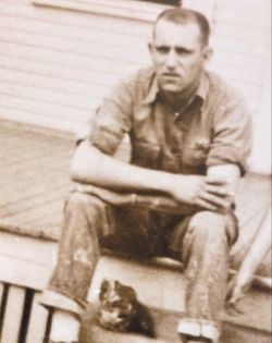
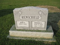
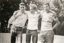
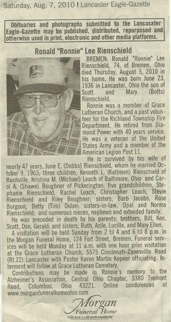
Ronald Lee “Ronnie” Rienschield
| Birth | : | 23 Jun 1936 Lancaster, Fairfield County, Ohio, USA |
| Death | : | 5 Aug 2010 Bremen, Fairfield County, Ohio, USA |
| Burial | : | Mount Pleasant United Methodist Church Cemetery, Talbott, Jefferson County, USA |
| Coordinate | : | 36.1323280, -83.4082031 |
| Description | : | Bremen: Ronald "Ronnie" Lee Rienschield, 74, of Bremen, Ohio died Thursday, August 5, 2010 in his home. He was born June 23, 1936 in Lancaster, Ohio the son of Scott and Mary (Botts) Rienschield. Ronnie was a member of Grace Lutheran Church, and a past volunteer for the Richland Township Fire Department. He retired from Diamond Power with 40 years service. He was a Veteran of the United States Army and a member of the American Legion Post 11. He is survived by his wife of nearly 47 years, June E. (Dodds) Rienschield whom he married October 9, 1963; three children,... Read More |
frequently asked questions (FAQ):
-
Where is Ronald Lee “Ronnie” Rienschield's memorial?
Ronald Lee “Ronnie” Rienschield's memorial is located at: Mount Pleasant United Methodist Church Cemetery, Talbott, Jefferson County, USA.
-
When did Ronald Lee “Ronnie” Rienschield death?
Ronald Lee “Ronnie” Rienschield death on 5 Aug 2010 in Bremen, Fairfield County, Ohio, USA
-
Where are the coordinates of the Ronald Lee “Ronnie” Rienschield's memorial?
Latitude: 36.1323280
Longitude: -83.4082031
Family Members:
Spouse

Flowers:


Nearby Cemetories:
1. Mount Pleasant United Methodist Church Cemetery
Talbott, Jefferson County, USA
Coordinate: 36.1323280, -83.4082031
2. Community Chapel Freewill Baptist Church Cemetery
Jefferson County, USA
Coordinate: 36.1273360, -83.3892030
3. Pleasant Ridge Cemetery
Talbott, Jefferson County, USA
Coordinate: 36.1406021, -83.3744812
4. Martha Sunderland Cemetery
Hamblen County, USA
Coordinate: 36.1664009, -83.4132996
5. Jefferson Memorial Gardens Cemetery
Jefferson City, Jefferson County, USA
Coordinate: 36.1366997, -83.4561005
6. Buffalo Grove Cemetery
Jefferson City, Jefferson County, USA
Coordinate: 36.1148500, -83.4530800
7. Couch Cemetery
Jefferson County, USA
Coordinate: 36.1488991, -83.3574982
8. Mount Horeb Cemetery
Jefferson County, USA
Coordinate: 36.0917015, -83.4300003
9. Couch Cemetery
Hamblen County, USA
Coordinate: 36.1492900, -83.3571700
10. Old Miller Cemetery
Talbott, Jefferson County, USA
Coordinate: 36.1189003, -83.3553009
11. Cedar Grove Cemetery
Morristown, Hamblen County, USA
Coordinate: 36.1697006, -83.3741989
12. Hull Cemetery
Hamblen County, USA
Coordinate: 36.1594009, -83.4558029
13. Lebanon Cemetery
Jefferson County, USA
Coordinate: 36.0932999, -83.4424973
14. Lebanon Cumberland Presbyterian Church Cemetery
Jefferson City, Jefferson County, USA
Coordinate: 36.0933600, -83.4426600
15. Mansfield Cemetery
Jefferson County, USA
Coordinate: 36.0881004, -83.3796997
16. Mountain View Cemetery
Mount Horeb, Jefferson County, USA
Coordinate: 36.0816994, -83.4186020
17. Lebanon Baptist Church Cemetery
Hamblen County, USA
Coordinate: 36.1674580, -83.4546920
18. Pleasant View Baptist Church Cemetery
Hamblen County, USA
Coordinate: 36.1835500, -83.4251100
19. Sartain Springs Cemetery
Jefferson County, USA
Coordinate: 36.1258316, -83.3413925
20. Winstead Cemetery
Hamblen County, USA
Coordinate: 36.1666600, -83.3555600
21. Ebenezer Methodist Cemetery
Jefferson City, Jefferson County, USA
Coordinate: 36.0994400, -83.3491600
22. Hickey Cemetery
Hamblen County, USA
Coordinate: 36.1638985, -83.3467026
23. Senter Memorial Church Cemetery
Panther Hills, Hamblen County, USA
Coordinate: 36.1862880, -83.3780810
24. Carter's Cemetery
Jefferson County, USA
Coordinate: 36.1435900, -83.3357700