
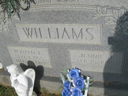
Ronald Lee Williams
| Birth | : | 1 Sep 1955 North Carolina, USA |
| Death | : | 15 May 1977 Mayodan, Rockingham County, North Carolina, USA |
| Burial | : | Dallas Presbyterian Cemetery, Marshall County, USA |
| Coordinate | : | 40.0145380, -80.5277320 |
| Description | : | Stoneville Man Drowns In Mayo A 21-year-old Stoneville man drowned Sunday after taking a dip in the Mayo River with some friends. Ronald Lee Williams, Rt. 2, Stoneville, was playing ball with some friends when they decided to cool off in the Mayo near the bridge on US Business 220 North of Mayodan. Deputy Lindsey Watkins, who investigated the mishap, said Williams waded up to his shoulders and the current carried him to a deeper section. He said Williams apparently could not swim very well. George Craig, who lives near the river, helped pull Williams out of the water and... Read More |
frequently asked questions (FAQ):
-
Where is Ronald Lee Williams's memorial?
Ronald Lee Williams's memorial is located at: Dallas Presbyterian Cemetery, Marshall County, USA.
-
When did Ronald Lee Williams death?
Ronald Lee Williams death on 15 May 1977 in Mayodan, Rockingham County, North Carolina, USA
-
Where are the coordinates of the Ronald Lee Williams's memorial?
Latitude: 40.0145380
Longitude: -80.5277320
Family Members:
Parent
Spouse

Siblings


Children
Flowers:


Nearby Cemetories:
1. Dallas Presbyterian Cemetery
Marshall County, USA
Coordinate: 40.0145380, -80.5277320
2. Dallas Cemetery
Dallas, Marshall County, USA
Coordinate: 40.0150300, -80.5262290
3. Mount View Cemetery
Dallas, Marshall County, USA
Coordinate: 40.0139008, -80.5231018
4. Dallas ME Church Cemetery
Ohio County, USA
Coordinate: 40.0175018, -80.5216980
5. Dreamer Cemetery
Richhill Township, Greene County, USA
Coordinate: 39.9603000, -80.5171000
6. Earlywine Cemetery
Marshall County, USA
Coordinate: 39.9919014, -80.5947037
7. Sand Hill Methodist Church Cemetery
Marshall County, USA
Coordinate: 39.9836410, -80.5900610
8. Jewish Memorial Park
Ohio County, USA
Coordinate: 40.0419700, -80.6107700
9. Memorial Cemetery
New Vrindaban, Marshall County, USA
Coordinate: 39.9686800, -80.6072200
10. Potter Farm Family Plot
Good Intent, Washington County, USA
Coordinate: 40.0461600, -80.4361500
11. Teagarden Cemetery
Richhill Township, Greene County, USA
Coordinate: 39.9692599, -80.4462719
12. Mount Hope Cemetery
Marshall County, USA
Coordinate: 39.9383011, -80.5449982
13. Sprowls Cemetery
East Finley, Washington County, USA
Coordinate: 40.0332985, -80.4268036
14. Crow Family Cemetery
Richhill Township, Greene County, USA
Coordinate: 39.9351000, -80.5159000
15. Our Lady of Seven Dolors Cemetery
Triadelphia, Ohio County, USA
Coordinate: 40.0543404, -80.6280594
16. Dogwood Grove Cemetery
Good Intent, Washington County, USA
Coordinate: 40.0577750, -80.4248570
17. Enon Cemetery
Richhill Township, Greene County, USA
Coordinate: 39.9742012, -80.4180984
18. Supler Cemetery
Richhill Township, Greene County, USA
Coordinate: 39.9740000, -80.4173000
19. Jones Cemetery
Richhill Township, Greene County, USA
Coordinate: 39.9739690, -80.4172750
20. Allum Cemetery
Richhill Township, Greene County, USA
Coordinate: 39.9738190, -80.4172770
21. Leslie Cemetery
Greene County, USA
Coordinate: 39.9730988, -80.4141998
22. Fairmount Cemetery
East Finley, Washington County, USA
Coordinate: 40.0244770, -80.4023770
23. Stone Church Cemetery
Wheeling, Ohio County, USA
Coordinate: 40.0416985, -80.6530991
24. Roneys Point Cemetery
Wheeling, Ohio County, USA
Coordinate: 40.0932530, -80.6105200