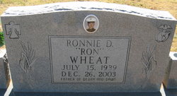
Ronnie D. “Ron” Wheat
| Birth | : | 15 Jul 1939 Alva, Woods County, Oklahoma, USA |
| Death | : | 26 Dec 2003 Portales, Roosevelt County, New Mexico, USA |
| Burial | : | Marcus-Amherst Cemetery, Marcus, Cherokee County, USA |
| Coordinate | : | 42.8161011, -95.8007965 |
| Description | : | Ron Wheat, 64, of Portales died Friday, Dec. 26, 2003, at his home. Born July 15, 1939, in Alva, Okla., to Freda and Blaine Wheat, he joined the National Guard, then the Army, and later the U.S. Marine Corps, for whom he was bulldogger on the rodeo team. Discharged in 1964, he worked at various jobs. About 1971, he lost his foot and part of a leg while working at a grain elevator, and later the entire leg was removed. For several years he sold cleaning supplies for Handi-Kleen. In 1980, he moved to Portales, did odd... Read More |
frequently asked questions (FAQ):
-
Where is Ronnie D. “Ron” Wheat's memorial?
Ronnie D. “Ron” Wheat's memorial is located at: Marcus-Amherst Cemetery, Marcus, Cherokee County, USA.
-
When did Ronnie D. “Ron” Wheat death?
Ronnie D. “Ron” Wheat death on 26 Dec 2003 in Portales, Roosevelt County, New Mexico, USA
-
Where are the coordinates of the Ronnie D. “Ron” Wheat's memorial?
Latitude: 42.8161011
Longitude: -95.8007965
Family Members:
Parent
Flowers:
Nearby Cemetories:
1. Marcus-Amherst Cemetery
Marcus, Cherokee County, USA
Coordinate: 42.8161011, -95.8007965
2. Holy Name Cemetery
Marcus, Cherokee County, USA
Coordinate: 42.8163986, -95.8032990
3. Trinity Lutheran Cemetery
Marcus, Cherokee County, USA
Coordinate: 42.7348000, -95.8208000
4. Maryhill Visitation Church Cemetery
Cherokee, Cherokee County, USA
Coordinate: 42.7360000, -95.6895000
5. Meriden Cemetery
Meriden, Cherokee County, USA
Coordinate: 42.7868996, -95.6425018
6. Liberty Cemetery
Meriden, Cherokee County, USA
Coordinate: 42.8368988, -95.6361008
7. Remsen Cemetery
Remsen, Plymouth County, USA
Coordinate: 42.8058014, -95.9775009
8. Saint Marys Cemetery
Remsen, Plymouth County, USA
Coordinate: 42.8078003, -95.9781036
9. Pleasant Hill Cemetery
Henry Township, Plymouth County, USA
Coordinate: 42.6921700, -95.8795700
10. Saint John Cemetery
Germantown, O'Brien County, USA
Coordinate: 42.9566994, -95.7799988
11. Mount Pleasant Cemetery
Quimby, Cherokee County, USA
Coordinate: 42.6671982, -95.7611008
12. Mount Calvary Cemetery
Cherokee, Cherokee County, USA
Coordinate: 42.7639008, -95.5847015
13. West Prairie View Cemetery
Paullina, O'Brien County, USA
Coordinate: 42.9688988, -95.7039032
14. Prairie View Cemetery
Paullina, O'Brien County, USA
Coordinate: 42.9688988, -95.7022018
15. Saint Joseph Catholic Cemetery
Granville, Sioux County, USA
Coordinate: 42.9813995, -95.8716965
16. Oak Hill Cemetery
Cherokee, Cherokee County, USA
Coordinate: 42.7496986, -95.5796967
17. Beacon Hollow Cemetery
Cherokee, Cherokee County, USA
Coordinate: 42.7572057, -95.5727856
18. George Donohoe Grave Site
Cherokee, Cherokee County, USA
Coordinate: 42.7571850, -95.5704080
19. Memory Gardens
Cherokee, Cherokee County, USA
Coordinate: 42.7778015, -95.5580978
20. Liberty Cemetery
Calumet, O'Brien County, USA
Coordinate: 42.9241982, -95.5932999
21. Saint Catherines Cemetery
Oyens, Plymouth County, USA
Coordinate: 42.8224200, -96.0563900
22. Cedar Cemetery
Larrabee, Cherokee County, USA
Coordinate: 42.8361015, -95.5346985
23. Grand Meadow Cemetery
Washta, Cherokee County, USA
Coordinate: 42.6164017, -95.8011017
24. Union Cemetery
Remsen, Plymouth County, USA
Coordinate: 42.6917000, -96.0291977


