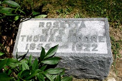
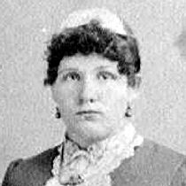
Rosetta Eugenia Carr Moore
| Birth | : | 3 Jun 1855 Fabius, Onondaga County, New York, USA |
| Death | : | 22 Mar 1922 Canton, Jones County, Iowa, USA |
| Burial | : | Huntington Cemetery, Huntington, Sebastian County, USA |
| Coordinate | : | 35.0946999, -94.2688980 |
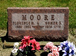
| Description | : | Wife of: Thomas Moore.∼Mar 31. 1922 Obituary Rosetta Eugenie Carr was born in Fabius New York, June 3rd, 1855, and died in Canton, Iowa, march 23, 1922, aged 66 years, 9 months, and 20 days. She was brought to Maquoketa, Iowa when two years old. On June 24th 1871 she was united in marriage to Thos. E. Moore; to this union were born nine children, seven of whom are living, and all attended the funeral; the living are, Edward E. of Wichita, Kansas; Leona Anthony of Deer Creek, Oklahoma; Leonard L. of Leon, Iowa; Homer S. of Leon; Grace... Read More |
frequently asked questions (FAQ):
-
Where is Rosetta Eugenia Carr Moore's memorial?
Rosetta Eugenia Carr Moore's memorial is located at: Huntington Cemetery, Huntington, Sebastian County, USA.
-
When did Rosetta Eugenia Carr Moore death?
Rosetta Eugenia Carr Moore death on 22 Mar 1922 in Canton, Jones County, Iowa, USA
-
Where are the coordinates of the Rosetta Eugenia Carr Moore's memorial?
Latitude: 35.0946999
Longitude: -94.2688980
Family Members:
Parent
Spouse
Siblings
Children
Flowers:
Nearby Cemetories:
1. Huntington Cemetery
Huntington, Sebastian County, USA
Coordinate: 35.0946999, -94.2688980
2. Old Miller Cemetery
Witcherville, Sebastian County, USA
Coordinate: 35.1167831, -94.2420197
3. Cherokee African American Cemetery
Huntington, Sebastian County, USA
Coordinate: 35.0778008, -94.3019028
4. Dayton Cemetery
Dayton, Sebastian County, USA
Coordinate: 35.1155670, -94.2295600
5. Coop Prairie Cemetery
Mansfield, Scott County, USA
Coordinate: 35.0649986, -94.2369003
6. Lovelace Cemetery
Witcherville, Sebastian County, USA
Coordinate: 35.1361008, -94.2686005
7. Butler Cemetery
Dayton, Sebastian County, USA
Coordinate: 35.1242294, -94.2250290
8. Lewis Cemetery
Sebastian County, USA
Coordinate: 35.1161003, -94.2106018
9. Clarks Chapel Cemetery
Dayton, Sebastian County, USA
Coordinate: 35.1462410, -94.2463830
10. Buggy Hill Cemetery
Sebastian County, USA
Coordinate: 35.0381012, -94.2611008
11. Union Ridge Cemetery
Crossroads, Sebastian County, USA
Coordinate: 35.1227989, -94.1977997
12. Bull Cemetery
Sebastian County, USA
Coordinate: 35.1142006, -94.1936035
13. Dake Cemetery
Sebastian County, USA
Coordinate: 35.1178017, -94.3494034
14. Sorrels Cemetery
Scott County, USA
Coordinate: 35.0806007, -94.1847000
15. Bethel Cemetery
Sebastian County, USA
Coordinate: 35.0264015, -94.2397003
16. Gilliam Cemetery
Witcherville, Sebastian County, USA
Coordinate: 35.1618996, -94.3035965
17. Bethel Cemetery
Scott County, USA
Coordinate: 35.0424995, -94.2058029
18. Cantrell Cemetery
Scott County, USA
Coordinate: 35.0275002, -94.2307968
19. Green Floyd Bethell Cemetery
Mansfield, Sebastian County, USA
Coordinate: 35.0223690, -94.2469990
20. Mount Olive Cemetery
Midland, Sebastian County, USA
Coordinate: 35.0992012, -94.3619003
21. Looper Cemetery
Scott County, USA
Coordinate: 35.0797005, -94.1750031
22. Valley View Cemetery
Midland, Sebastian County, USA
Coordinate: 35.1514015, -94.3399963
23. Shiloh Cemetery
Mansfield, Sebastian County, USA
Coordinate: 35.0223630, -94.3141450
24. Mount Harmony Cemetery
Greenwood, Sebastian County, USA
Coordinate: 35.1759262, -94.2368774

