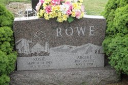
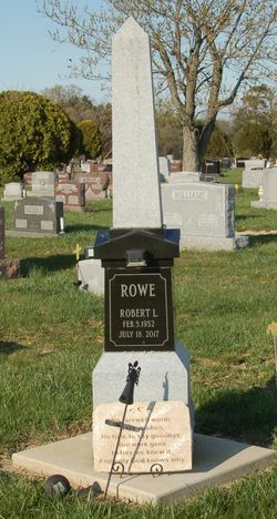
Rosie Puckett Rowe
| Birth | : | 14 Mar 1913 Floyd County, Kentucky, USA |
| Death | : | 8 Nov 2001 Kenton, Hardin County, Ohio, USA |
| Burial | : | Preston Cemetery, Alger, Hardin County, USA |
| Coordinate | : | 40.7106018, -83.8227997 |
| Plot | : | Section 3, row 23 |
| Description | : | Rosie Rowe, 88, of Dola and formerly of Alger, died Thursday, November 8, 2001 at Hardin Memorial Hospital, Kenton. She was born March 14, 1913 in Floyd County, Kentucky, to Ira R. and Mirah (Yates) Puckett, both of whom are deceased. On October 17, 1940, she married Archie Rowe, who passed away on May 1, 1991. Survivors include six sons: Sam (Donna) Rowe of Dola, Ted (Georgette) Rowe of Alger, Oscar (Linda) Rowe of Alger, Robert (Lorna) Rowe of Kenton, Bill (Rita) Rowe of Rushsylvania, and Dean Rowe of Alger; a daughter, Mary Ann (Joel) Kritzler of Kenton; 20 grandchildren, 30 great-grandchildren and... Read More |
frequently asked questions (FAQ):
-
Where is Rosie Puckett Rowe's memorial?
Rosie Puckett Rowe's memorial is located at: Preston Cemetery, Alger, Hardin County, USA.
-
When did Rosie Puckett Rowe death?
Rosie Puckett Rowe death on 8 Nov 2001 in Kenton, Hardin County, Ohio, USA
-
Where are the coordinates of the Rosie Puckett Rowe's memorial?
Latitude: 40.7106018
Longitude: -83.8227997
Family Members:
Spouse
Children
Flowers:
Nearby Cemetories:
1. Preston Cemetery
Alger, Hardin County, USA
Coordinate: 40.7106018, -83.8227997
2. Shadley Cemetery
Hardin County, USA
Coordinate: 40.7111015, -83.8041992
3. Woodlawn Cemetery
Ada, Hardin County, USA
Coordinate: 40.7461014, -83.8227997
4. Carman Cemetery
Hardin County, USA
Coordinate: 40.7318993, -83.8617020
5. Huntersville Cemetery
Hardin County, USA
Coordinate: 40.7224998, -83.7630997
6. Maysville Cemetery
Hardin County, USA
Coordinate: 40.7336006, -83.8775024
7. Saint Paul Cemetery
Ada, Hardin County, USA
Coordinate: 40.7565060, -83.8614960
8. Heterick Memorial Library
Ada, Hardin County, USA
Coordinate: 40.7672360, -83.8277080
9. Ridge Cemetery
Harrod, Allen County, USA
Coordinate: 40.7178001, -83.9000015
10. Harrod Cemetery
Harrod, Allen County, USA
Coordinate: 40.7178001, -83.9242020
11. Cessna-Obenour Cemetery
Hardin County, USA
Coordinate: 40.7291610, -83.7237600
12. West Newton Cemetery
Allen County, USA
Coordinate: 40.6535988, -83.8983002
13. Old Pleasant Hill Cemetery
Roundhead Township, Hardin County, USA
Coordinate: 40.6241400, -83.8423000
14. Smith Cemetery
Hardin County, USA
Coordinate: 40.7327995, -83.7108002
15. New Pleasant Hill Cemetery
Roundhead, Hardin County, USA
Coordinate: 40.6235780, -83.8412940
16. Kindle Cemetery
Ada, Hardin County, USA
Coordinate: 40.7916985, -83.8696976
17. Desenberg Cemetery
Lafayette, Allen County, USA
Coordinate: 40.7752991, -83.9083023
18. Auglaize Cemetery
Allen County, USA
Coordinate: 40.6810989, -83.9372025
19. Candler Cemetery
Ada, Hardin County, USA
Coordinate: 40.7919006, -83.8792038
20. Fisher Cemetery
Lafayette, Allen County, USA
Coordinate: 40.7425003, -83.9375000
21. Mount Zion Cemetery
Allen County, USA
Coordinate: 40.6521988, -83.9178009
22. Evick Cemetery
Allen County, USA
Coordinate: 40.7914009, -83.8961029
23. Hullibarger Cemetery
Harrod, Allen County, USA
Coordinate: 40.7099020, -83.9564210
24. McElroy Cemetery
Ada, Hardin County, USA
Coordinate: 40.8083000, -83.7838974

