
| Birth | : | 29 May 1866 Stratford, Hamilton County, Iowa, USA |
| Death | : | 23 Apr 1942 Valentine, Cherry County, Nebraska, USA |
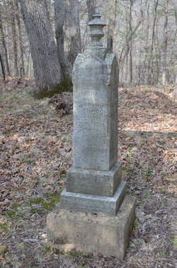
| Burial | : | Prairie Lawn Cemetery, Cody, Cherry County, USA |
| Coordinate | : | 42.9290000, -101.2260000 |
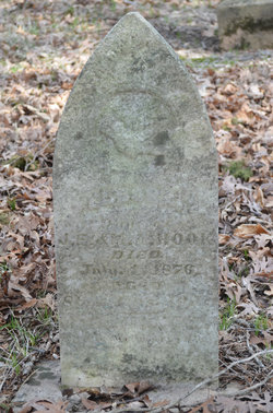
| Description | : | The people of Cody were sorry to learn of the death of Ross Hook, who passed away on Thursday of last week, after being quite ill for several months. Mr. Hook had a large circle of friends in our community, having been one of Cody's earlier citizens. He did blacksmithing in Cody for about thirty years and moved to Valentine two years ago. A large crowd attended the funeral service to pay tribute to one who had been their friend for many years in the past. The funeral was conducted by Rev. Slagg on Saturday, at the Methodist Church. The... Read More |
frequently asked questions (FAQ):
-
Where is Roswell “Ross” Hook's memorial?
Roswell “Ross” Hook's memorial is located at: Prairie Lawn Cemetery, Cody, Cherry County, USA.
-
When did Roswell “Ross” Hook death?
Roswell “Ross” Hook death on 23 Apr 1942 in Valentine, Cherry County, Nebraska, USA
-
Where are the coordinates of the Roswell “Ross” Hook's memorial?
Latitude: 42.9290000
Longitude: -101.2260000
Family Members:
Parent

Spouse
Siblings
Children
Flowers:


Nearby Cemetories:
1. Prairie Lawn Cemetery
Cody, Cherry County, USA
Coordinate: 42.9290000, -101.2260000
2. Saint Marys Cemetery
Nenzel, Cherry County, USA
Coordinate: 42.9300000, -101.0920000
3. Guerue Cemetery
Todd County, USA
Coordinate: 43.0353012, -101.1144028
4. Conley Flats Cemetery
Eli, Cherry County, USA
Coordinate: 42.8796100, -101.4355000
5. Kilgore Cemetery
Kilgore, Cherry County, USA
Coordinate: 42.9304110, -100.9639260
6. Saint Patrick Cemetery
Spring Creek, Todd County, USA
Coordinate: 43.0961300, -101.0471200
7. Saint Angelo Cemetery
Spring Creek, Todd County, USA
Coordinate: 43.0960999, -101.0468979
8. Williamson Gravesite
Nenzel, Cherry County, USA
Coordinate: 42.7888000, -100.9909000
9. Saint Marys Cemetery
Todd County, USA
Coordinate: 43.1892014, -101.1314011
10. Star Cemetery
Saint Francis, Todd County, USA
Coordinate: 43.1041985, -100.9263992
11. Our Lady of the Lake Cemetery
Bennett County, USA
Coordinate: 43.0647011, -101.5761032
12. Tuthill Cemetery
Tuthill, Bennett County, USA
Coordinate: 43.1575430, -101.4750170
13. German Settlement Cemetery
Cherry County, USA
Coordinate: 42.8419050, -100.8393860
14. Arcoren Family Cemetery
Saint Francis, Todd County, USA
Coordinate: 43.1676300, -100.9830700
15. Running Cemetery
Saint Francis, Todd County, USA
Coordinate: 43.1672490, -100.9807097
16. Saint Charles Catholic Cemetery
Saint Francis, Todd County, USA
Coordinate: 43.1418530, -100.9020750
17. Lamson Cemetery
Cherry County, USA
Coordinate: 42.6264300, -101.0907900
18. Peyote Cemetery
Todd County, USA
Coordinate: 43.2392006, -101.0958023
19. Sacred Heart Catholic Cemetery
Parmelee, Todd County, USA
Coordinate: 43.2444200, -101.1182400
20. Hollow Horn Bear Cemetery
Todd County, USA
Coordinate: 43.2510986, -101.1025009
21. Grace Episcopal Cemetery
Martin, Bennett County, USA
Coordinate: 43.0938111, -101.6325167
22. Saint Elizabeth Catholic Cemetery
Merriman, Cherry County, USA
Coordinate: 42.9229020, -101.6926280
23. Epiphany Episcopal Cemetery
Todd County, USA
Coordinate: 43.2681007, -101.1442032
24. Saint Patrick Cemetery
Saint Francis, Todd County, USA
Coordinate: 43.2715900, -101.1602500