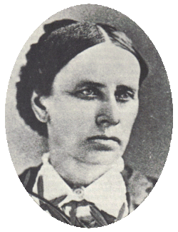
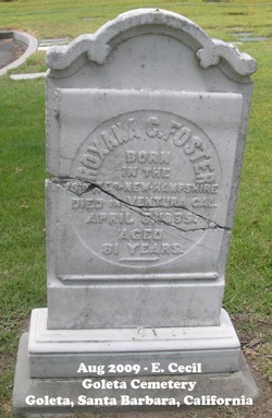
Roxana Cheney Foster
| Birth | : | 2 Apr 1818 New Hampshire, USA |
| Death | : | 6 Apr 1899 Ventura County, California, USA |
| Burial | : | Horse Meadow Cemetery, North Haverhill, Grafton County, USA |
| Coordinate | : | 44.1068880, -72.0405500 |
frequently asked questions (FAQ):
-
Where is Roxana Cheney Foster's memorial?
Roxana Cheney Foster's memorial is located at: Horse Meadow Cemetery, North Haverhill, Grafton County, USA.
-
When did Roxana Cheney Foster death?
Roxana Cheney Foster death on 6 Apr 1899 in Ventura County, California, USA
-
Where are the coordinates of the Roxana Cheney Foster's memorial?
Latitude: 44.1068880
Longitude: -72.0405500
Family Members:
Spouse
Children
Flowers:

Left by Anonymous on 01 Jan 2012

Left by Anonymous on 06 Jan 2012
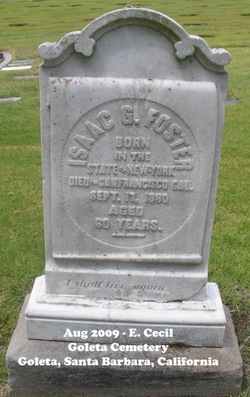
Roxanna (Cheney) Foster was the daughter of CAPT David Cheney and Louisa Ball. She was born in Groton, Grafton Co., New Hampshire. She married Isaac Giles Foster 6/26/1845
Left by Anonymous on 10 May 2012
GOD BLESS
Left by Anonymous on 18 Oct 2012
Left by Anonymous on 03 Nov 2013

Left by Anonymous on 22 Jun 2022
Nearby Cemetories:
1. Horse Meadow Cemetery
North Haverhill, Grafton County, USA
Coordinate: 44.1068880, -72.0405500
2. Horse Meadow Annex Cemetery
North Haverhill, Grafton County, USA
Coordinate: 44.1056820, -72.0408260
3. Oxbow Cemetery
Newbury, Orange County, USA
Coordinate: 44.0881830, -72.0486670
4. Abbott Cemetery
North Haverhill, Grafton County, USA
Coordinate: 44.0821730, -72.0186420
5. Pine Grove Cemetery
Woodsville, Grafton County, USA
Coordinate: 44.1380997, -72.0188980
6. Wells River Cemetery
Wells River, Orange County, USA
Coordinate: 44.1535988, -72.0547028
7. Center Haverhill Cemetery
Center Haverhill, Grafton County, USA
Coordinate: 44.0770650, -71.9868740
8. Boltonville Cemetery
Boltonville, Orange County, USA
Coordinate: 44.1575012, -72.0877991
9. Town House Cemetery
Newbury Center, Orange County, USA
Coordinate: 44.1066322, -72.1256943
10. Ladd Street Cemetery
Haverhill, Grafton County, USA
Coordinate: 44.0439600, -72.0532800
11. Swiftwater Cemetery
Bath, Grafton County, USA
Coordinate: 44.1303400, -71.9574300
12. Carbee Cemetery
Bath, Grafton County, USA
Coordinate: 44.1724640, -72.0466980
13. Saint Joseph Cemetery
Bath, Grafton County, USA
Coordinate: 44.1803017, -72.0524979
14. West Newbury Cemetery
West Newbury, Orange County, USA
Coordinate: 44.0591800, -72.1246900
15. West Bath Cemetery
Bath, Grafton County, USA
Coordinate: 44.1750930, -71.9865080
16. Carbee District Cemetery
Bath, Grafton County, USA
Coordinate: 44.1881040, -72.0521310
17. Rogers Hill Cemetery
West Newbury, Orange County, USA
Coordinate: 44.0550003, -72.1322021
18. Bath Village Cemetery
Bath, Grafton County, USA
Coordinate: 44.1693500, -71.9617800
19. East Haverhill Cemetery
East Haverhill, Grafton County, USA
Coordinate: 44.0289688, -71.9889297
20. Jefferson Hill Cemetery
Newbury, Orange County, USA
Coordinate: 44.1658400, -72.1424200
21. Old Scotch Cemetery
Ryegate, Caledonia County, USA
Coordinate: 44.1969000, -72.0928600
22. Number 6 Cemetery
East Haverhill, Grafton County, USA
Coordinate: 44.0326400, -71.9518600
23. West Cemetery
Benton, Grafton County, USA
Coordinate: 44.1033700, -71.9014000
24. Bedel Cemetery
Bath, Grafton County, USA
Coordinate: 44.2075000, -72.0455560


