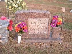
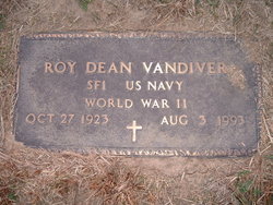
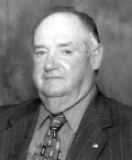
Roy Dean “Dag” Vandiver
| Birth | : | 27 Oct 1923 Ray County, Missouri, USA |
| Death | : | 3 Aug 1993 Ray County, Missouri, USA |
| Burial | : | Banta Cemetery, Sewal, Wayne County, USA |
| Coordinate | : | 40.6096992, -93.3103027 |
| Plot | : | Section 9 |
| Inscription | : | SF1 U S NAVY WORLD WAR II |
frequently asked questions (FAQ):
-
Where is Roy Dean “Dag” Vandiver's memorial?
Roy Dean “Dag” Vandiver's memorial is located at: Banta Cemetery, Sewal, Wayne County, USA.
-
When did Roy Dean “Dag” Vandiver death?
Roy Dean “Dag” Vandiver death on 3 Aug 1993 in Ray County, Missouri, USA
-
Where are the coordinates of the Roy Dean “Dag” Vandiver's memorial?
Latitude: 40.6096992
Longitude: -93.3103027
Family Members:
Parent
Spouse
Siblings
Children
Nearby Cemetories:
1. Banta Cemetery
Sewal, Wayne County, USA
Coordinate: 40.6096992, -93.3103027
2. Thomas Cemetery
Wayne County, USA
Coordinate: 40.6333008, -93.3099976
3. Edmond Cemetery
Wayne County, USA
Coordinate: 40.5849991, -93.3193970
4. Medicineville Cemetery
Wayne County, USA
Coordinate: 40.5811005, -93.2878036
5. Moss Sturgeon Cemetery
Wayne County, USA
Coordinate: 40.6399994, -93.2861023
6. Greer Cemetery
Wayne County, USA
Coordinate: 40.5833015, -93.3735962
7. Powersville Cemetery
Powersville, Putnam County, USA
Coordinate: 40.5527992, -93.3131027
8. Richardson Chapel Cemetery
Harvard, Wayne County, USA
Coordinate: 40.6694412, -93.2981262
9. Rankin Cemetery
Allerton, Wayne County, USA
Coordinate: 40.6719017, -93.3360977
10. Shriver Cemetery
Wayne County, USA
Coordinate: 40.6808014, -93.2621994
11. Wyreka Cemetery
Putnam County, USA
Coordinate: 40.5297012, -93.2794037
12. Harris Cemetery
Wayne County, USA
Coordinate: 40.6225014, -93.1877975
13. Pleasant View Cemetery
Wayne County, USA
Coordinate: 40.6072006, -93.1828003
14. Green Ridge Cemetery
Allerton, Wayne County, USA
Coordinate: 40.6664009, -93.4261017
15. Hickerson-Stacker Cemetery
Seymour, Wayne County, USA
Coordinate: 40.6597000, -93.1874000
16. Ripper Cemetery
Corydon, Wayne County, USA
Coordinate: 40.6957000, -93.2290000
17. Amish Hidden Acres Rest Cemetery
Seymour, Wayne County, USA
Coordinate: 40.6312450, -93.1734310
18. Saint John Cemetery West
Putnam County, USA
Coordinate: 40.5425670, -93.1903500
19. Allerton Cemetery
Allerton, Wayne County, USA
Coordinate: 40.7202988, -93.3542023
20. Sharp Cemetery
Wayne County, USA
Coordinate: 40.6916700, -93.2002000
21. Clio Cemetery
Clio, Wayne County, USA
Coordinate: 40.6341742, -93.4654947
22. Tharp Cemetery
Seymour, Wayne County, USA
Coordinate: 40.6474991, -93.1572037
23. Wilder Cemetery
Mercer County, USA
Coordinate: 40.5463982, -93.4539032
24. Torrey Cemetery
Putnam County, USA
Coordinate: 40.5149994, -93.1947021

