
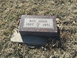
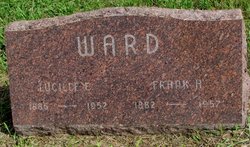
Roy John Ward
| Birth | : | 30 May 1887 Vermillion, Clay County, South Dakota, USA |
| Death | : | 16 Sep 1951 Clay County, South Dakota, USA |
| Burial | : | Saint Columbkill Cemetery, Wakonda, Clay County, USA |
| Coordinate | : | 43.0642014, -97.0828018 |
| Plot | : | B |
| Description | : | His father was born in Canada and his mother in IL. He married Katherine B Dose on February 15, 1912 in Clay Co., SD. His WWI draft registration card from June 5, 1917, describes him as tall, stout, and with blue eyes and dark hair. Paper Trail * 1917 (Jun 5): Wakonda, Clay Co., SD. Farmer. * 1920 (Jan 9): Riverside Twp, Clay Co., SD. Age 32. With Catherine B, wife, 29. * 1930 (Apr 5-8): Riverside Twp, Clay Co., SD. Age 42. With Catherine, wife, 40; and Harvey Lafgren, lodger, 28. Farmer. * 1940 (Apr 15): Riverside Twp, Clay Co., SD. Age 52. With... Read More |
frequently asked questions (FAQ):
-
Where is Roy John Ward's memorial?
Roy John Ward's memorial is located at: Saint Columbkill Cemetery, Wakonda, Clay County, USA.
-
When did Roy John Ward death?
Roy John Ward death on 16 Sep 1951 in Clay County, South Dakota, USA
-
Where are the coordinates of the Roy John Ward's memorial?
Latitude: 43.0642014
Longitude: -97.0828018
Family Members:
Parent

Spouse
Siblings

Flowers:


Nearby Cemetories:
1. Saint Columbkill Cemetery
Wakonda, Clay County, USA
Coordinate: 43.0642014, -97.0828018
2. Holland Cemetery
Centerville, Turner County, USA
Coordinate: 43.1114006, -97.0314026
3. Hillcrest Cemetery
Yankton County, USA
Coordinate: 43.0835991, -97.1680984
4. Hansen Cemetery
Turner County, USA
Coordinate: 43.1260986, -97.1511002
5. Riverside-Barton Cemetery
Clay County, USA
Coordinate: 43.0402985, -96.9725037
6. Union Cemetery
Wakonda, Clay County, USA
Coordinate: 42.9827995, -97.1222000
7. Turkey Valley Baptist Cemetery
Yankton County, USA
Coordinate: 43.1260100, -97.1800110
8. Salem Cemetery
Yankton County, USA
Coordinate: 43.0830180, -97.2090590
9. Turkey Valley Lutheran Cemetery
Yankton County, USA
Coordinate: 43.1257950, -97.1803430
10. CJ Anderson Homestead
Riverside Township, Clay County, USA
Coordinate: 43.0214180, -96.9675540
11. Pioneer Cemetery
Yankton County, USA
Coordinate: 43.0758018, -97.2118988
12. Saint Patricks Catholic Cemetery
Wakonda, Clay County, USA
Coordinate: 42.9672012, -97.0516968
13. Grace Lutheran Cemetery
Turner County, USA
Coordinate: 43.1489100, -97.0034000
14. Rose Hill Cemetery
Viborg, Turner County, USA
Coordinate: 43.1669000, -97.0813000
15. Baptist Cemetery
Viborg, Turner County, USA
Coordinate: 43.1702000, -97.0512000
16. Old Lodi Cemetery
Lodi, Clay County, USA
Coordinate: 42.9757996, -96.9907990
17. Evangelical Cemetery
Turner County, USA
Coordinate: 43.1569950, -96.9931519
18. Bethania Cemetery
Viborg, Turner County, USA
Coordinate: 43.1702995, -97.1417007
19. New Lodi Cemetery
Lodi, Clay County, USA
Coordinate: 42.9530983, -97.0417023
20. Riverview Cemetery
Centerville, Turner County, USA
Coordinate: 43.1333008, -96.9567032
21. Trondhjem Cemetery
Volin, Yankton County, USA
Coordinate: 43.0325400, -97.2346200
22. Volin Cemetery
Volin, Yankton County, USA
Coordinate: 42.9672012, -97.1707993
23. Zion Cemetery
Volin, Yankton County, USA
Coordinate: 42.9963300, -97.2234600
24. Bethel Baptist Cemetery
Wakonda, Clay County, USA
Coordinate: 42.9393570, -97.0433520