
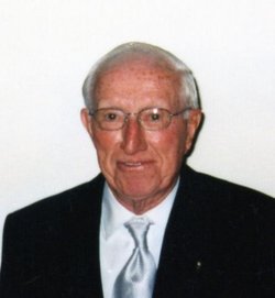
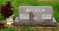
Roy King Morehead
| Birth | : | 18 Apr 1922 Iowa, USA |
| Death | : | 24 Jan 2014 Arizona, USA |
| Burial | : | Mount Hope Cemetery, Maquoketa, Jackson County, USA |
| Coordinate | : | 42.0615616, -90.6619720 |
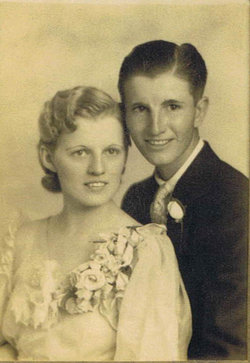
| Description | : | ROY MOREHEAD Roy K. Morehead, 91, of Cottonwood, Arizona and formerly of Maquoketa, Iowa died on January 24, 2014 at his home in Cottonwood. A celebration of Roy's life will be held at a later date at the Carson Celebration of Life Center in Maquoketa. Burial will be in the Mount Hope Cemetery in Maquoketa. Roy King Morehead was born on April 18, 1922 in Jackson County to Howard and Frances (Sutton) Morehead. He married Eleanor L. (Sal) Penrose on September 6, 1942. Eleanor died February 3, 1987. He served honorably in the US Navy during World War II from October... Read More |
frequently asked questions (FAQ):
-
Where is Roy King Morehead's memorial?
Roy King Morehead's memorial is located at: Mount Hope Cemetery, Maquoketa, Jackson County, USA.
-
When did Roy King Morehead death?
Roy King Morehead death on 24 Jan 2014 in Arizona, USA
-
Where are the coordinates of the Roy King Morehead's memorial?
Latitude: 42.0615616
Longitude: -90.6619720
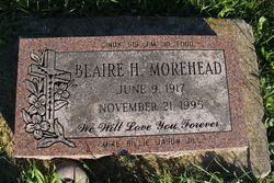
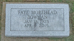
Family Members:
Parent

Spouse
Siblings
Flowers:


Nearby Cemetories:
1. Mount Hope Cemetery
Maquoketa, Jackson County, USA
Coordinate: 42.0615616, -90.6619720
2. Sacred Heart Cemetery
Maquoketa, Jackson County, USA
Coordinate: 42.0583496, -90.6617966
3. Bridgeport Cemetery
Maquoketa, Jackson County, USA
Coordinate: 42.0906000, -90.6267000
4. Union Cemetery
Brookfield Township, Clinton County, USA
Coordinate: 42.0182991, -90.6694031
5. Goddard Cemetery
Maquoketa, Jackson County, USA
Coordinate: 42.0391998, -90.7335968
6. Codfish Hollow Cemetery
Maquoketa, Jackson County, USA
Coordinate: 42.0727997, -90.5793991
7. Tilton Cemetery
Jackson County, USA
Coordinate: 42.1236000, -90.6798000
8. Buckhorn Waterford Cemetery
Buckhorn, Jackson County, USA
Coordinate: 42.0607986, -90.7517014
9. Saint Patrick's Cemetery
Delmar, Clinton County, USA
Coordinate: 42.0036011, -90.6149979
10. Esgate Cemetery
Maquoketa, Jackson County, USA
Coordinate: 42.1292000, -90.7142029
11. Rathbun Cemetery
Maquoketa, Jackson County, USA
Coordinate: 42.0402000, -90.5570000
12. Evergreen Cemetery
Delmar, Clinton County, USA
Coordinate: 41.9897003, -90.6057968
13. Elwood Cemetery
Elwood, Clinton County, USA
Coordinate: 41.9935989, -90.7307968
14. Risinger Cemetery
Andrew, Jackson County, USA
Coordinate: 42.1241787, -90.5548475
15. Union Center Cemetery
Maquoketa, Jackson County, USA
Coordinate: 42.0546989, -90.5246964
16. Saint Johns Catholic Cemetery
Andrew, Jackson County, USA
Coordinate: 42.1509760, -90.5888680
17. Andrew Cemetery
Andrew, Jackson County, USA
Coordinate: 42.1519430, -90.5895330
18. Busch Cemetery
Clinton County, USA
Coordinate: 41.9996986, -90.7818985
19. Pence Cemetery
Baldwin, Jackson County, USA
Coordinate: 42.0746994, -90.8106003
20. East Iron Hill Cemetery
Farmers Creek Township, Jackson County, USA
Coordinate: 42.1465797, -90.7591019
21. Sutton Cemetery
Fulton, Jackson County, USA
Coordinate: 42.1677000, -90.7143000
22. West Iron Hill Cemetery
Jackson County, USA
Coordinate: 42.1460000, -90.7686000
23. Bloomfield Cemetery
Clinton County, USA
Coordinate: 41.9458008, -90.6194000
24. Springbrook Amish-Mennonite Cemetery
Bellevue, Jackson County, USA
Coordinate: 42.1570340, -90.5515440