
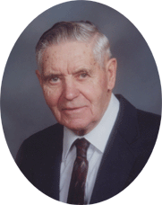
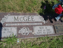
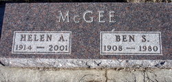
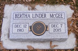
Roy R. McGee
| Birth | : | 14 May 1919 Sargent, Custer County, Nebraska, USA |
| Death | : | 10 Sep 2007 Columbus, Platte County, Nebraska, USA |
| Burial | : | Churchs Ferry Cemetery, Churchs Ferry, Ramsey County, USA |
| Coordinate | : | 48.2522011, -99.1883011 |
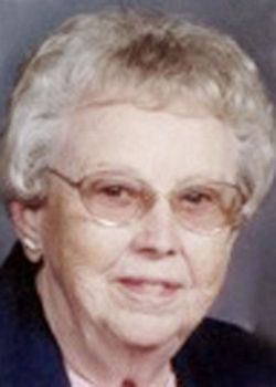
| Description | : | Son of Hiram & Addie (Decker) McGee. He attended schools in Knox County, Nebraska. On June 22, 1944, Roy enlisted into the US Army, serving during WWII. He was honorably discharged on June 6, 1946, after receiving the Good Conduct Medal, the WWII Victory Ribbon, the Purple Heart , and the Bronze Star. Roy married Thelma Harden on December 28, 1946 in Storm Lake, Iowa. They farmed in Cherokee County, Iowa, for several years before moving to Columbus, Nebraska, in 1957. Roy worked for Fleischer Manufacturing as a design engineer for 28 years. During his... Read More |
frequently asked questions (FAQ):
-
Where is Roy R. McGee's memorial?
Roy R. McGee's memorial is located at: Churchs Ferry Cemetery, Churchs Ferry, Ramsey County, USA.
-
When did Roy R. McGee death?
Roy R. McGee death on 10 Sep 2007 in Columbus, Platte County, Nebraska, USA
-
Where are the coordinates of the Roy R. McGee's memorial?
Latitude: 48.2522011
Longitude: -99.1883011
Family Members:
Parent
Spouse
Siblings

Flowers:


Nearby Cemetories:
1. Churchs Ferry Cemetery
Churchs Ferry, Ramsey County, USA
Coordinate: 48.2522011, -99.1883011
2. Antiochia Cemetery
Benson County, USA
Coordinate: 48.2242310, -99.2136320
3. Presbyterian Cemetery
Ramsey County, USA
Coordinate: 48.2235985, -99.1371994
4. Saint Paul Cemetery
Ramsey County, USA
Coordinate: 48.2164001, -99.1138992
5. Big Coulee Cemetery
Ramsey County, USA
Coordinate: 48.1786170, -99.1794710
6. Lebanon Cemetery
Benson County, USA
Coordinate: 48.2243650, -99.3278750
7. Almlie Cemetery
Ramsey County, USA
Coordinate: 48.3344002, -99.0914001
8. Saint Johns Catholic Cemetery
Brinsmade, Benson County, USA
Coordinate: 48.1879060, -99.3189280
9. Chain Lake Lutheran Cemetery
Garske, Ramsey County, USA
Coordinate: 48.3254100, -99.0389000
10. Brinsmade Lutheran Cemetery
Brinsmade, Benson County, USA
Coordinate: 48.1796989, -99.3394012
11. Norway Lutheran Church Cemetery
Devils Lake, Ramsey County, USA
Coordinate: 48.1397282, -99.0712715
12. Wilmerth Cemetery
Benson County, USA
Coordinate: 48.2155991, -99.4135971
13. Grand Harbor Cemetery
Ramsey County, USA
Coordinate: 48.1585999, -98.9897003
14. Saint Vincent DePaul Catholic Cemetery
Leeds, Benson County, USA
Coordinate: 48.2966240, -99.4267850
15. Leeds Cemetery
Leeds, Benson County, USA
Coordinate: 48.3036003, -99.4368973
16. Olson Cemetery
Maza, Towner County, USA
Coordinate: 48.4291992, -99.2097015
17. Webster Cemetery
Ramsey County, USA
Coordinate: 48.2813988, -98.9180984
18. Minnewaukan Cemetery
Minnewaukan, Benson County, USA
Coordinate: 48.0671997, -99.2711029
19. Saint James Catholic Cemetery
Minnewaukan, Benson County, USA
Coordinate: 48.0663564, -99.2706200
20. Trinity Free Cemetery
Minnewaukan, Benson County, USA
Coordinate: 48.0656773, -99.2706352
21. Saint Peter Cemetery
Minnewaukan, Benson County, USA
Coordinate: 48.0639000, -99.2696991
22. Ostreim Cemetery
Towner County, USA
Coordinate: 48.3852997, -99.4049988
23. Wahl Cemetery
Towner County, USA
Coordinate: 48.3891983, -99.4049988
24. North Prairie Lutheran Church Cemetery
Towner County, USA
Coordinate: 48.3894610, -99.4284490