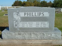
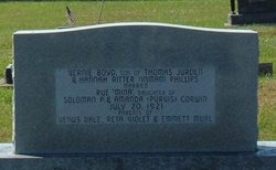
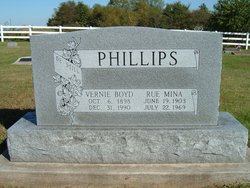
Rue Mina “Mina” Corwin Phillips
| Birth | : | 19 Jun 1903 Scotland County, Missouri, USA |
| Death | : | 22 Jul 1969 Kirksville, Adair County, Missouri, USA |
| Burial | : | Red River Cemetery, Kennedy, Kittson County, USA |
| Coordinate | : | 48.6599998, -97.0360031 |
| Inscription | : | age 66y 1m 3d |
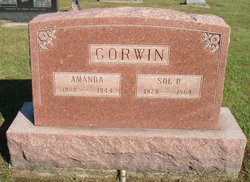
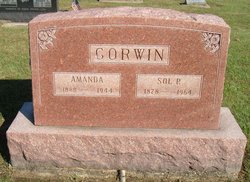
| Description | : | Services Held For Mina Phillips Mrs. Mina Phillips, 66, of Baring, Missouri, died Tuesday, July 22, 1969, at 1 a.m. in the Laughlin Hospital, Kirksville, Missouri. Funeral services were held Thursday, at two p.m. in the Church of Christ of Bible Grove. Burial will be in the church cemetery. Mrs. Phillips was born in Scotland County, June 19, 1903, a daughter of Sol and Amanda Purvis Corwin. She was a member of the Church of Christ of Bible Grove. She was married to Vernie Phillips, July 20, 1921, in Memphis. Surviving are the husband; a son, Emmett, of Memphis; a daughter, Mrs. Rita Kittle, of... Read More |
frequently asked questions (FAQ):
-
Where is Rue Mina “Mina” Corwin Phillips's memorial?
Rue Mina “Mina” Corwin Phillips's memorial is located at: Red River Cemetery, Kennedy, Kittson County, USA.
-
When did Rue Mina “Mina” Corwin Phillips death?
Rue Mina “Mina” Corwin Phillips death on 22 Jul 1969 in Kirksville, Adair County, Missouri, USA
-
Where are the coordinates of the Rue Mina “Mina” Corwin Phillips's memorial?
Latitude: 48.6599998
Longitude: -97.0360031
Family Members:
Parent
Spouse
Siblings
Children
Flowers:
Nearby Cemetories:
1. Red River Cemetery
Kennedy, Kittson County, USA
Coordinate: 48.6599998, -97.0360031
2. Tabitha Lutheran Church Cemetery
Kittson County, USA
Coordinate: 48.7313700, -97.1004300
3. Skjeberg Cemetery
Robbin, Kittson County, USA
Coordinate: 48.5911530, -97.1064280
4. Teien Covenant Cemetery
Robbin, Kittson County, USA
Coordinate: 48.5843510, -97.1047980
5. Kennedy Cemetery
Kennedy, Kittson County, USA
Coordinate: 48.6453018, -96.8983002
6. Tree Claim Cemetery
Davis Township, Kittson County, USA
Coordinate: 48.6298000, -96.8996670
7. Bowesmont Cemetery
Bowesmont, Pembina County, USA
Coordinate: 48.6879720, -97.1890940
8. Hillcrest Cemetery
Donaldson, Kittson County, USA
Coordinate: 48.5872002, -96.8878021
9. Greenwood Cemetery
Hallock, Kittson County, USA
Coordinate: 48.7720130, -96.9326270
10. Saint Edward Cemetery
Drayton, Pembina County, USA
Coordinate: 48.5727768, -97.1886063
11. Drayton Cemetery
Drayton, Pembina County, USA
Coordinate: 48.5722008, -97.1889038
12. Eagle Point Cemetery
Marshall County, USA
Coordinate: 48.5296410, -97.1077490
13. Union Liberty Cemetery
Hallock, Kittson County, USA
Coordinate: 48.7743988, -96.8672028
14. Two Rivers Cemetery
Hallock, Kittson County, USA
Coordinate: 48.7462997, -96.8314133
15. West Emmaus Cemetery
Kittson County, USA
Coordinate: 48.6591988, -96.7797012
16. Bethlehem Cemetery
Kittson County, USA
Coordinate: 48.7606010, -96.8210983
17. Jupiter Community Cemetery
Kittson County, USA
Coordinate: 48.6694400, -96.7582900
18. Jupiter Mission Cemetery
Kittson County, USA
Coordinate: 48.6439018, -96.7589035
19. East Emmaus Cemetery
Lake Bronson, Kittson County, USA
Coordinate: 48.6693993, -96.7577972
20. Oak View Catholic Cemetery
Northcote, Kittson County, USA
Coordinate: 48.8492012, -96.9961014
21. Johansson Cemetery
Lake Bronson, Kittson County, USA
Coordinate: 48.6925800, -96.7477000
22. Adams Farm Cemetery
Kittson County, USA
Coordinate: 48.6996700, -96.7487700
23. Saron Cemetery
Lancaster, Kittson County, USA
Coordinate: 48.8036003, -96.8383026
24. Morrison Cemetery
Northcote, Kittson County, USA
Coordinate: 48.8525600, -96.9975800

