

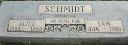
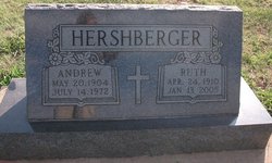
Ruth Alice Schmidt Hershberger
| Birth | : | 24 Apr 1910 Harper, Harper County, Kansas, USA |
| Death | : | 13 Jan 2005 Hesston, Harvey County, Kansas, USA |
| Burial | : | Kirkhill Cemetery, Sussex, Kings County, Canada |
| Coordinate | : | 45.7267300, -65.5178300 |
| Description | : | Ruth Alice (Schmidt) Hershberger, 94, of Hesston, Kan., died Jan. 13, 2005. She was born on April 24, 1910, to Samuel G. and Alice (Shupe) Schmidt at Harper. She graduated from Hesston Academy in 1928. She attended Goshen (Ind.) College for one year. In 1999, at age 89, she completed a course in "Introduction to Biblical Literature" at Hesston College. In 1919, she accepted Jesus Christ as her personal Savior, was baptized and became an active member of Pleasant Valley Mennonite Church. She was also an associate member of Hesston Mennonite Church. On May 4, 1947, she married Andrew Hershberger... Read More |
frequently asked questions (FAQ):
-
Where is Ruth Alice Schmidt Hershberger's memorial?
Ruth Alice Schmidt Hershberger's memorial is located at: Kirkhill Cemetery, Sussex, Kings County, Canada.
-
When did Ruth Alice Schmidt Hershberger death?
Ruth Alice Schmidt Hershberger death on 13 Jan 2005 in Hesston, Harvey County, Kansas, USA
-
Where are the coordinates of the Ruth Alice Schmidt Hershberger's memorial?
Latitude: 45.7267300
Longitude: -65.5178300
Family Members:
Parent

Spouse
Siblings
Children
Flowers:


Nearby Cemetories:
1. Kirkhill Cemetery
Sussex, Kings County, Canada
Coordinate: 45.7267300, -65.5178300
2. Roachville Cemetery
Roachville, Kings County, Canada
Coordinate: 45.7309420, -65.5343880
3. Evergreen Memorial Park Cemetery
Sussex, Kings County, Canada
Coordinate: 45.7321130, -65.4902570
4. Muslim Cemetery
Sussex, Kings County, Canada
Coordinate: 45.7327100, -65.4890500
5. Trinity Cemetery
Sussex Corner, Kings County, Canada
Coordinate: 45.7055200, -65.4808300
6. Saint Francis Xavier Catholic Cemetery
Wards Creek, Kings County, Canada
Coordinate: 45.6889840, -65.5115620
7. Church of the Ascension Cemetery
Apohaqui, Kings County, Canada
Coordinate: 45.7035420, -65.6026760
8. Lower Millstream Baptist Cemetery
Lower Millstream, Kings County, Canada
Coordinate: 45.7625130, -65.6044220
9. Wesley United Church Cemetery
Berwick, Kings County, Canada
Coordinate: 45.7806952, -65.5931468
10. Fenwick Burial Ground
Berwick, Kings County, Canada
Coordinate: 45.7769170, -65.6010280
11. Pioneer Cemetery
Penobsquis, Kings County, Canada
Coordinate: 45.7578500, -65.4124300
12. Smith's Creek United Cemetery
Smiths Creek, Kings County, Canada
Coordinate: 45.8021180, -65.4711360
13. Gosline Cemetery
Smiths Creek, Kings County, Canada
Coordinate: 45.7998500, -65.4571000
14. Creightonville Cemetery
Waterford, Kings County, Canada
Coordinate: 45.6921100, -65.3985000
15. Riverbank Community Cemetery
Riverbank, Kings County, Canada
Coordinate: 45.6711200, -65.6546400
16. Anderson Cemetery
Penobsquis, Kings County, Canada
Coordinate: 45.7774180, -65.3714340
17. Newtown Baptist Cemetery
Newtown, Kings County, Canada
Coordinate: 45.8334300, -65.4457700
18. Collina Baptist Cemetery
Collina, Kings County, Canada
Coordinate: 45.7839300, -65.6685900
19. Walker Settlement Cemetery
Walker Settlement, Kings County, Canada
Coordinate: 45.6428510, -65.3899900
20. Cardwell Baptist Cemetery
Penobsquis, Kings County, Canada
Coordinate: 45.7817400, -65.3607090
21. Upper Springfield Community Cemetery
Collina, Kings County, Canada
Coordinate: 45.7677838, -65.6846841
22. St. Michael's Roman Catholic Cemetery
Newtown, Kings County, Canada
Coordinate: 45.8411190, -65.4311100
23. Snider Mountain United Church Cemetery
Snider Mountain, Kings County, Canada
Coordinate: 45.8314160, -65.6358530
24. Keirstead Mountain Baptist Church Cemetery
Kierstead Mountain, Kings County, Canada
Coordinate: 45.8161000, -65.6628800