
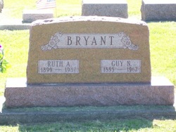
Ruth Armilda Sanders Bryant
| Birth | : | 17 Apr 1899 |
| Death | : | 16 Jul 1987 |
| Burial | : | Colrain West Branch Cemetery, Colrain, Franklin County, USA |
| Coordinate | : | 42.6671982, -72.7221985 |
| Plot | : | Section 13, Row 2 |
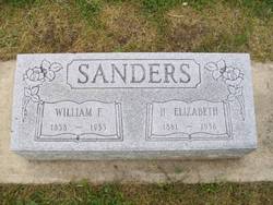
| Description | : | Published in The Rochester Sentinel Tuesday, June 16, 1987 Ruth A. Bryant Ruth Armilda BRYANT, 88, of 212 W. Third St., died at 8:10 a.m. today at the Rochester Nursing Home where she had resided for five days. She had been in failing health for several years. She was born April 17, 1899 in Traer, Iowa, to William and Elizabeth MANNING SANDERS. She had lived in this community since the age of two. On May 5, 1917 in Rochester she married Guy N. BRYANT, who died July 5, 1962. She was a member of the First Church... Read More |
frequently asked questions (FAQ):
-
Where is Ruth Armilda Sanders Bryant's memorial?
Ruth Armilda Sanders Bryant's memorial is located at: Colrain West Branch Cemetery, Colrain, Franklin County, USA.
-
When did Ruth Armilda Sanders Bryant death?
Ruth Armilda Sanders Bryant death on 16 Jul 1987 in
-
Where are the coordinates of the Ruth Armilda Sanders Bryant's memorial?
Latitude: 42.6671982
Longitude: -72.7221985
Family Members:
Parent

Spouse

Siblings

Children
Flowers:


Nearby Cemetories:
1. Colrain West Branch Cemetery
Colrain, Franklin County, USA
Coordinate: 42.6671982, -72.7221985
2. Chandler Hill Cemetery
Colrain, Franklin County, USA
Coordinate: 42.6683006, -72.6832962
3. North River Cemetery
Colrain, Franklin County, USA
Coordinate: 42.6856003, -72.6917038
4. Brick School Cemetery
Colrain, Franklin County, USA
Coordinate: 42.6641998, -72.6660995
5. Arms Cemetery
Shelburne Falls, Franklin County, USA
Coordinate: 42.6166992, -72.7332993
6. Christian Hill Cemetery
Colrain, Franklin County, USA
Coordinate: 42.7158012, -72.7643967
7. West Leyden Cemetery
Leyden, Franklin County, USA
Coordinate: 42.7061005, -72.6572037
8. East Shelburne Cemetery
Shelburne, Franklin County, USA
Coordinate: 42.6105995, -72.6694031
9. South Leyden Cemetery
Leyden, Franklin County, USA
Coordinate: 42.6831400, -72.6311200
10. East Charlemont Cemetery
Charlemont, Franklin County, USA
Coordinate: 42.6197853, -72.7932739
11. Center Cemetery
Heath, Franklin County, USA
Coordinate: 42.6819000, -72.8167038
12. Henry Farm Cemetery
West Halifax, Windham County, USA
Coordinate: 42.7379712, -72.7132938
13. Brown Cemetery
West Dummerston, Windham County, USA
Coordinate: 42.7392340, -72.7135850
14. Hill Cemetery
Shelburne, Franklin County, USA
Coordinate: 42.5984344, -72.6878815
15. East Buckland Cemetery
Buckland, Franklin County, USA
Coordinate: 42.5962500, -72.7610600
16. Bell Cemetery
Halifax, Windham County, USA
Coordinate: 42.7423800, -72.6972900
17. Old East Buckland Cemetery
Buckland, Franklin County, USA
Coordinate: 42.5969400, -72.7677900
18. Stark Cemetery
Guilford, Windham County, USA
Coordinate: 42.7402992, -72.6746979
19. Clark Family Cemetery
Halifax, Windham County, USA
Coordinate: 42.7479180, -72.7103090
20. South Cemetery
Heath, Franklin County, USA
Coordinate: 42.6542015, -72.8321991
21. North Meadows Cemetery
Greenfield, Franklin County, USA
Coordinate: 42.6171989, -72.6333008
22. Country Farms Cemetery
Greenfield, Franklin County, USA
Coordinate: 42.6393900, -72.6165400
23. Pennel Hill Cemetery
Halifax, Windham County, USA
Coordinate: 42.7364006, -72.7857971
24. Shelburne Center Cemetery
Shelburne, Franklin County, USA
Coordinate: 42.5830000, -72.6969600