Ruth Edna Kirchner Adams
| Birth | : | 13 Mar 1912 Walla Walla, Walla Walla County, Washington, USA |
| Death | : | 10 Oct 1998 East Wenatchee, Douglas County, Washington, USA |
| Burial | : | Saint Josephs Cemetery, Duncombe, Webster County, USA |
| Coordinate | : | 42.4789009, -93.9922028 |
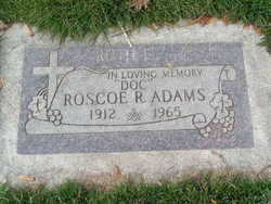
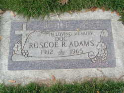
| Description | : | m: in 1935 in Yakima Co, WA The Wenatchee World - Oct. 15, 1998 Ruth Edna Adams, 86, a resident of East Wenatchee for the past 29 years, died Saturday, Oct. 10, 1998 at Highline Convalescent Center in East Wenatchee. She was born on March 13, 1912 to Gus Adolph and Sadie (Koch) Kirchner at Walla Walla. At a very young age, Ruth moved with her family to the lower Yakima Valley where she attended school and later graduated from Sunnyside High School. She married Roscoe "Doc" Adams on Aug. 31, 1935 at Yakima. They made their first home at Outlook.... Read More |
frequently asked questions (FAQ):
-
Where is Ruth Edna Kirchner Adams's memorial?
Ruth Edna Kirchner Adams's memorial is located at: Saint Josephs Cemetery, Duncombe, Webster County, USA.
-
When did Ruth Edna Kirchner Adams death?
Ruth Edna Kirchner Adams death on 10 Oct 1998 in East Wenatchee, Douglas County, Washington, USA
-
Where are the coordinates of the Ruth Edna Kirchner Adams's memorial?
Latitude: 42.4789009
Longitude: -93.9922028
Family Members:
Spouse
Flowers:
Nearby Cemetories:
1. Saint Josephs Cemetery
Duncombe, Webster County, USA
Coordinate: 42.4789009, -93.9922028
2. Washington Township Cemetery
Duncombe, Webster County, USA
Coordinate: 42.4707900, -94.0002000
3. Colfax Cemetery
Webster County, USA
Coordinate: 42.5224991, -94.0194016
4. Washington Cemetery
Duncombe, Webster County, USA
Coordinate: 42.4277992, -93.9916992
5. Blanchard Cemetery
Webster County, USA
Coordinate: 42.4021988, -93.9997025
6. Holaday Creek Cemetery
Webster County, USA
Coordinate: 42.4472008, -94.0886002
7. Ober and Scott Cemetery
Duncombe, Webster County, USA
Coordinate: 42.3841390, -93.9982856
8. Border Plains Cemetery
Border Plains, Webster County, USA
Coordinate: 42.3917000, -94.0448000
9. Hartman Cemetery
Lehigh, Webster County, USA
Coordinate: 42.3666397, -93.9835627
10. Fort Dodge Memorial Park
Fort Dodge, Webster County, USA
Coordinate: 42.5032997, -94.1472015
11. Otho Cemetery
Otho, Webster County, USA
Coordinate: 42.4025002, -94.1153030
12. Community Church Cemetery
Kamrar, Hamilton County, USA
Coordinate: 42.4556000, -93.8342000
13. Calvary Cemetery
Webster City, Hamilton County, USA
Coordinate: 42.4556007, -93.8341980
14. Graceland Cemetery
Webster City, Hamilton County, USA
Coordinate: 42.4578018, -93.8308029
15. Teters Family Cemetery
Vincent, Webster County, USA
Coordinate: 42.6005700, -94.0034200
16. Homer Cemetery
Homer, Hamilton County, USA
Coordinate: 42.3680992, -93.9088974
17. Newark Township Cemetery
Vincent, Webster County, USA
Coordinate: 42.6021996, -94.0408020
18. West Lawn Cemetery
Lehigh, Webster County, USA
Coordinate: 42.3616982, -94.0678024
19. Trails End Cemetery
Webster City, Hamilton County, USA
Coordinate: 42.4587810, -93.8128710
20. Troy Cemetery
Woolstock, Wright County, USA
Coordinate: 42.6011009, -93.9077988
21. McGuire Bend Cemetery
Dayton, Webster County, USA
Coordinate: 42.3410000, -93.9880000
22. Oak Grove Cemetery
Lehigh, Webster County, USA
Coordinate: 42.3438988, -94.0475006
23. Oakland Cemetery
Fort Dodge, Webster County, USA
Coordinate: 42.5214005, -94.1800003
24. North Lawn Cemetery
Fort Dodge, Webster County, USA
Coordinate: 42.5290000, -94.1778000


