

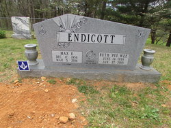
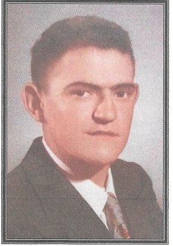
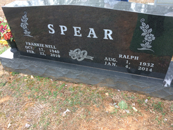
Ruth Elizabeth “PeeWee” Spear Endicott
| Birth | : | 14 Jun 1938 Celina, Clay County, Tennessee, USA |
| Death | : | 27 Jan 2013 Livingston, Overton County, Tennessee, USA |
| Burial | : | Spear Family Cemetery, Moss, Clay County, USA |
| Coordinate | : | 36.5933200, -85.5876500 |
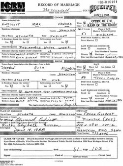
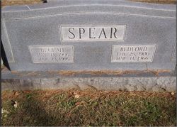
| Description | : | LIVINGSTON, Tenn. — Ruth Elizabeth (Spear) Endicott better known as "Peewee," 74, of the Oak Grove Community of Clay County, passed away Jan. 27, 2013, at the Livingston Regional Hospital. Peewee was born on June 14, 1938, in Celina, Tenn., to the late Bedford and Beulah (Dunning) Spear. She worked at Saint John's Hospital for 30 years in Anderson, Ind., and was a member of the Church of Christ. She was preceded in death by her parents, Bedford and Beulah (Dunning) Spear; a sister, Cricket Spear; and uncle, Winton Spear. Services will be held at 11 a.m. Friday in the chapel of the Hall... Read More |
frequently asked questions (FAQ):
-
Where is Ruth Elizabeth “PeeWee” Spear Endicott's memorial?
Ruth Elizabeth “PeeWee” Spear Endicott's memorial is located at: Spear Family Cemetery, Moss, Clay County, USA.
-
When did Ruth Elizabeth “PeeWee” Spear Endicott death?
Ruth Elizabeth “PeeWee” Spear Endicott death on 27 Jan 2013 in Livingston, Overton County, Tennessee, USA
-
Where are the coordinates of the Ruth Elizabeth “PeeWee” Spear Endicott's memorial?
Latitude: 36.5933200
Longitude: -85.5876500
Family Members:
Parent
Spouse
Siblings


Flowers:


Nearby Cemetories:
1. Spear Family Cemetery
Moss, Clay County, USA
Coordinate: 36.5933200, -85.5876500
2. Meadows Cemetery
Clay County, USA
Coordinate: 36.5946999, -85.5875015
3. McLerran Cemetery
Moss, Clay County, USA
Coordinate: 36.5790000, -85.5973000
4. Odle Cemetery
Clay County, USA
Coordinate: 36.5966988, -85.6085968
5. New Hope Cemetery
Clay County, USA
Coordinate: 36.6021996, -85.5653000
6. Moss Cemetery
Moss, Clay County, USA
Coordinate: 36.5911210, -85.6214460
7. Strong Family Cemetery
Clay County, USA
Coordinate: 36.5690700, -85.6042600
8. Macedonia Cemetery
Moss, Clay County, USA
Coordinate: 36.5643997, -85.6110992
9. Walker Reecer Cemetery
Celina, Clay County, USA
Coordinate: 36.5746290, -85.5480270
10. Moore Cemetery
Moss, Clay County, USA
Coordinate: 36.6113400, -85.6374980
11. Kendall Cemetery
Moss, Clay County, USA
Coordinate: 36.5672540, -85.6362650
12. Freedom Cemetery #2
Tompkinsville, Monroe County, USA
Coordinate: 36.6284060, -85.6289940
13. Liberty Church Cemetery
Boles, Clay County, USA
Coordinate: 36.6010850, -85.6496830
14. Willhoite-Curtis Cemetery
Tompkinsville, Monroe County, USA
Coordinate: 36.6182208, -85.6442948
15. Plumlee Cemetery
Celina, Clay County, USA
Coordinate: 36.5694280, -85.5282830
16. Dalton Cemetery
Arcott, Clay County, USA
Coordinate: 36.5429540, -85.5546170
17. Eads-Denton Cemetery
Pine Hill, Clay County, USA
Coordinate: 36.5644207, -85.6503187
18. Smith Cemetery
Pine Hill, Clay County, USA
Coordinate: 36.5714930, -85.6568170
19. Bailey Cemetery
Tompkinsville, Monroe County, USA
Coordinate: 36.6530991, -85.5994034
20. Varney Andrews Cemetery
Celina, Clay County, USA
Coordinate: 36.5604650, -85.5209530
21. Stephens Cemetery
Monroe County, USA
Coordinate: 36.6314011, -85.5252991
22. Stone Cemetery
Clay County, USA
Coordinate: 36.5713997, -85.5136032
23. Old Bob Wood Place Cemetery
Boles, Monroe County, USA
Coordinate: 36.6325120, -85.6515600
24. Baxter Cemetery
Hestand, Monroe County, USA
Coordinate: 36.6501460, -85.6264790