
| Birth | : | 18 Sep 1893 Lyons, Burt County, Nebraska, USA |
| Death | : | 28 Nov 1952 Boone, Boone County, Iowa, USA |
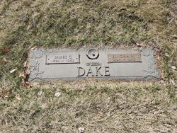
| Burial | : | St. John the Evangelist Churchyard, Barnsley, Metropolitan Borough of Barnsley, England |
| Coordinate | : | 53.5888100, -1.5000800 |
| Plot | : | SA |
| Description | : | Ruth was born Ruth Ella Dake in Lyons, Burt County Nebraska. She married John Victor Fullerton on Nov. 8 1913 in Des Moines, Polk County, Iowa. Ruth and John had 9 children, Paulyne, Lucille, Harrison (Jack), Lorraine, Richard, Melvin, Roy, James and Robert. Somewhere between 1934 and 1938 her and John divorced and she stayed a single parent until all her children were grown. Then she remarried |
frequently asked questions (FAQ):
-
Where is Ruth Ella Dake Holm's memorial?
Ruth Ella Dake Holm's memorial is located at: St. John the Evangelist Churchyard, Barnsley, Metropolitan Borough of Barnsley, England.
-
When did Ruth Ella Dake Holm death?
Ruth Ella Dake Holm death on 28 Nov 1952 in Boone, Boone County, Iowa, USA
-
Where are the coordinates of the Ruth Ella Dake Holm's memorial?
Latitude: 53.5888100
Longitude: -1.5000800
Family Members:
Parent

Spouse
Siblings
Children
Flowers:


Nearby Cemetories:
1. St. John the Evangelist Churchyard
Barnsley, Metropolitan Borough of Barnsley, England
Coordinate: 53.5888100, -1.5000800
2. All Saints Churchyard
Darton, Metropolitan Borough of Barnsley, England
Coordinate: 53.5840700, -1.5312900
3. St. Peter's Churchyard
Woolley, Metropolitan Borough of Wakefield, England
Coordinate: 53.6125990, -1.5186320
4. Royston Cemetery
Royston, Metropolitan Borough of Barnsley, England
Coordinate: 53.5966100, -1.4527080
5. St. Thomas Churchyard
Gawber, Metropolitan Borough of Barnsley, England
Coordinate: 53.5604400, -1.5139500
6. St. John the Baptist Churchyard
Royston, Metropolitan Borough of Barnsley, England
Coordinate: 53.5964400, -1.4511390
7. Carlton Cemetery
Carlton, Metropolitan Borough of Barnsley, England
Coordinate: 53.5880460, -1.4490910
8. Quaker Burial Ground
Monk Bretton, Metropolitan Borough of Barnsley, England
Coordinate: 53.5664870, -1.4601690
9. Friends Burial Ground
Barnsley, Metropolitan Borough of Barnsley, England
Coordinate: 53.5575420, -1.4846400
10. Monk Bretton Friends Burial Ground
Barnsley, Metropolitan Borough of Barnsley, England
Coordinate: 53.5664190, -1.4596850
11. St. Mary's Churchyard
Barnsley, Metropolitan Borough of Barnsley, England
Coordinate: 53.5553950, -1.4828870
12. Monk Bretton Cemetery
Monk Bretton, Metropolitan Borough of Barnsley, England
Coordinate: 53.5635590, -1.4536210
13. St. Paul Churchyard
Monk Bretton, Metropolitan Borough of Barnsley, England
Coordinate: 53.5639600, -1.4525200
14. St. George's Churchyard
Barnsley, Metropolitan Borough of Barnsley, England
Coordinate: 53.5507250, -1.4852520
15. St Bartholomew Chapelyard
West Bretton, Metropolitan Borough of Wakefield, England
Coordinate: 53.6117750, -1.5638600
16. Barnsley Cemetery
Barnsley, Metropolitan Borough of Barnsley, England
Coordinate: 53.5468597, -1.4684340
17. Cawthorne Cemetery
Barnsley, Metropolitan Borough of Barnsley, England
Coordinate: 53.5673699, -1.5713055
18. Monk Bretton Priory
Lundwood, Metropolitan Borough of Barnsley, England
Coordinate: 53.5540130, -1.4383720
19. Dodworth Cemetery
Barnsley, Metropolitan Borough of Barnsley, England
Coordinate: 53.5417500, -1.5331500
20. Cudworth Cemetery
Cudworth, Metropolitan Borough of Barnsley, England
Coordinate: 53.5750100, -1.4173400
21. St John the Baptist Church
Dodworth, Metropolitan Borough of Barnsley, England
Coordinate: 53.5410200, -1.5303300
22. St John The Baptist
Cudworth, Metropolitan Borough of Barnsley, England
Coordinate: 53.5745520, -1.4166300
23. All Hallows Churchyard
High Hoyland, Metropolitan Borough of Barnsley, England
Coordinate: 53.5915000, -1.5868500
24. Saint Peter's Churchyard
Felkirk, Metropolitan Borough of Wakefield, England
Coordinate: 53.6085380, -1.4167850