
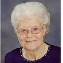

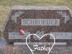
Ruth Emma Lage Schroeder
| Birth | : | 26 Feb 1918 Arcadia Township, Carroll County, Iowa, USA |
| Death | : | 26 Feb 2018 Denison, Crawford County, Iowa, USA |
| Burial | : | Westside Cemetery, Westside, Crawford County, USA |
| Coordinate | : | 42.0602989, -95.0922012 |
| Description | : | Ruth E. Schroeder February 26, 1918 - February 26, 2018 Ruth E. (Lage) Schroeder was born at the family farm home near Arcadia, Iowa, on February 26, 1918, the daughter of Jacob and Emma Lage. She passed away Monday, February 26, 2018, on her one-hundredth birthday, at Eventide Lutheran Home in Denison, Iowa. Ruth was baptized in Christ and later confirmed her faith April 9, 1933, at Zion Lutheran Church in Manning, Iowa. She received her education at Manning, graduating from Manning High School in May of 1935. She was employed at Marten’s Variety Store until moving to California in the winter of... Read More |
frequently asked questions (FAQ):
-
Where is Ruth Emma Lage Schroeder's memorial?
Ruth Emma Lage Schroeder's memorial is located at: Westside Cemetery, Westside, Crawford County, USA.
-
When did Ruth Emma Lage Schroeder death?
Ruth Emma Lage Schroeder death on 26 Feb 2018 in Denison, Crawford County, Iowa, USA
-
Where are the coordinates of the Ruth Emma Lage Schroeder's memorial?
Latitude: 42.0602989
Longitude: -95.0922012
Family Members:

Spouse
Flowers:


Nearby Cemetories:
1. Westside Cemetery
Westside, Crawford County, USA
Coordinate: 42.0602989, -95.0922012
2. Saint Johns Catholic Cemetery
Arcadia, Carroll County, USA
Coordinate: 42.0855406, -95.0341577
3. Hayes Township Cemetery
Westside, Crawford County, USA
Coordinate: 42.0083199, -95.1216583
4. Saint Anns Cemetery
Vail, Crawford County, USA
Coordinate: 42.0513992, -95.1868973
5. Arcadia Cemetery
Arcadia Township, Carroll County, USA
Coordinate: 42.1000680, -95.0130550
6. Vail Cemetery
Vail, Crawford County, USA
Coordinate: 42.0647011, -95.2102966
7. Saint Augustine Cemetery
Halbur, Carroll County, USA
Coordinate: 42.0066986, -94.9744034
8. King Cemetery
Vail, Crawford County, USA
Coordinate: 42.1007996, -95.2319031
9. Saint Francis Cemetery
Maple River, Carroll County, USA
Coordinate: 42.0969009, -94.9372025
10. Wheatland Cemetery
Carroll County, USA
Coordinate: 42.1814003, -95.0582962
11. Iowa Township Cemetery
Aspinwall, Crawford County, USA
Coordinate: 41.9216995, -95.1113968
12. Holy Angels Cemetery
Carroll County, USA
Coordinate: 42.0014000, -94.9141998
13. Saint Bernards Cemetery
Breda, Carroll County, USA
Coordinate: 42.1786003, -94.9732971
14. Sacred Heart Cemetery
Manning, Carroll County, USA
Coordinate: 41.9132500, -95.0540000
15. Manning Cemetery
Manning, Carroll County, USA
Coordinate: 41.8990000, -95.0620000
16. Our Lady Of Mount Carmel Cemetery
Mount Carmel, Carroll County, USA
Coordinate: 42.1547012, -94.9088974
17. Deloit Cemetery
Deloit, Crawford County, USA
Coordinate: 42.1075325, -95.3136520
18. South Wall Lake Cemetery
Wall Lake, Sac County, USA
Coordinate: 42.2318993, -95.0911026
19. Carroll City Cemetery
Carroll, Carroll County, USA
Coordinate: 42.0560963, -94.8599856
20. Mount Olivet Cemetery
Carroll, Carroll County, USA
Coordinate: 42.0536340, -94.8595510
21. Saint John Lutheran Church Cemetery
Crawford County, USA
Coordinate: 42.1780000, -95.2650000
22. Old Catholic Cemetery
Denison, Crawford County, USA
Coordinate: 42.0043983, -95.3189011
23. Sacred Heart Cemetery
Templeton, Carroll County, USA
Coordinate: 41.9138746, -94.9460994
24. Immanuel Presbyterian Cemetery
Carnarvon, Sac County, USA
Coordinate: 42.2392006, -95.0224991