
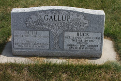
Ruth Gorman Gallup
| Birth | : | 24 Dec 1930 Chinook, Blaine County, Montana, USA |
| Death | : | 20 Apr 2005 Yakima, Yakima County, Washington, USA |
| Burial | : | Sweet Grass Cemetery, Sweet Grass, Toole County, USA |
| Coordinate | : | 48.9972120, -111.9966140 |
| Inscription | : | Beloved Wife, Mother, Grandmother May she rest in peace |
| Description | : | Ruth Gallup, age 74, entered the kingdom of heaven April 20, 2005, due to a battle with cancer. Ruth was living in Yakima, Wash., at the time of her death. Ruth was born Dec. 24, 1930, to Donald and Emma Gorman in Chinook, where she grew up with her four brothers and four sisters. Ruth moved to Sweet Grass and married Fredrick (Buck) Gallup. They farmed for many years and raised three children. Ruth had many occupations, but was best known for her cinnamon rolls at the Glocca Morra Café. She is survived by her three children, seven... Read More |
frequently asked questions (FAQ):
-
Where is Ruth Gorman Gallup's memorial?
Ruth Gorman Gallup's memorial is located at: Sweet Grass Cemetery, Sweet Grass, Toole County, USA.
-
When did Ruth Gorman Gallup death?
Ruth Gorman Gallup death on 20 Apr 2005 in Yakima, Yakima County, Washington, USA
-
Where are the coordinates of the Ruth Gorman Gallup's memorial?
Latitude: 48.9972120
Longitude: -111.9966140
Family Members:
Spouse
Flowers:


Nearby Cemetories:
1. Sweet Grass Cemetery
Sweet Grass, Toole County, USA
Coordinate: 48.9972120, -111.9966140
2. Holy Angels Cemetery Community
Coutts, Lethbridge Census Division, Canada
Coordinate: 48.9989440, -111.9649050
3. Coutts Cemetery
Coutts, Lethbridge Census Division, Canada
Coordinate: 48.9989690, -111.9647810
4. Hillside Hutterite Colony Cemetery
Toole County, USA
Coordinate: 48.9788000, -112.0740000
5. Rimrock Colony Cemetery
Toole County, USA
Coordinate: 48.8985000, -112.0980000
6. Sunburst Cemetery
Sunburst, Toole County, USA
Coordinate: 48.8847800, -111.8743800
7. Milk River Cemetery
Milk River, Lethbridge Census Division, Canada
Coordinate: 49.1442000, -112.0658700
8. Allerston Cemetery
Milk River, Lethbridge Census Division, Canada
Coordinate: 49.1451500, -111.7664000
9. Glacier Colony Cemetery
Glacier Colony, Glacier County, USA
Coordinate: 48.8313000, -112.2154000
10. Nutter Ranch Cemetery
Sunburst, Toole County, USA
Coordinate: 48.9668200, -111.6365320
11. Dahlen Family Homestead Cemetery
Kevin, Toole County, USA
Coordinate: 48.7504200, -112.1016200
12. Masinasin Cemetery
Milk River, Lethbridge Census Division, Canada
Coordinate: 49.1302328, -111.6527199
13. Zenith Colony Cemetery
Cut Bank, Glacier County, USA
Coordinate: 48.8678000, -112.3442000
14. Horizon Colony Cemetery
Cut Bank, Glacier County, USA
Coordinate: 48.7156000, -112.2290000
15. Warner Memorial Cemetery
Warner, Lethbridge Census Division, Canada
Coordinate: 49.2914900, -112.2246800
16. Prairie Round Cemetery
Lucky Strike, Lethbridge Census Division, Canada
Coordinate: 49.2249600, -111.5523800
17. Glendale Colony Cemetery
Glendale Colony, Glacier County, USA
Coordinate: 48.8380000, -112.5457000
18. Crown Hill Cemetery
Cut Bank, Glacier County, USA
Coordinate: 48.6542015, -112.3218994
19. Gold Butte Cemetery
Toole County, USA
Coordinate: 48.8793983, -111.3966980
20. Sunnyside Cemetery
Aden, Medicine Hat Census Division, Canada
Coordinate: 49.0286300, -111.3240800
21. Valley View Cemetery
Shelby, Toole County, USA
Coordinate: 48.5190000, -111.8863000
22. Whitlash Cemetery
Liberty County, USA
Coordinate: 48.9085999, -111.2699966
23. New Dayton Community Cemetery
New Dayton, Lethbridge Census Division, Canada
Coordinate: 49.4254300, -112.3601800
24. Seville Colony Cemetery
Seville Colony, Glacier County, USA
Coordinate: 48.7021000, -112.5943000