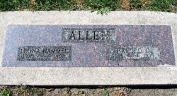
| Birth | : | 12 Sep 1920 |
| Death | : | 14 Apr 2020 |
| Burial | : | Monmouth Cemetery, Monmouth, Jackson County, USA |
| Coordinate | : | 42.0679300, -90.8798400 |
| Description | : | Ruth Mayberry September 12, 1920 - April 14, 2020 Williamsburg- Ruth Jeanette Mayberry was born October 12, 1920, in Wyoming Township in Jones County Iowa. The daughter of Lee Miles and Aletha Louisa (Trimble) Allen. Ruth grew up in Jones county. She was united in marriage on February 8, 1941 to Dale R Mayberry at the Monmouth Methodist Church. They lived in Albany, New York, while her husband served in the military then they moved to Williamsburg. Ruth was a member of the American Legion Auxiliary and a past member of the Federated Club, a member of... Read More |
frequently asked questions (FAQ):
-
Where is Ruth Jeanette Allen Mayberry's memorial?
Ruth Jeanette Allen Mayberry's memorial is located at: Monmouth Cemetery, Monmouth, Jackson County, USA.
-
When did Ruth Jeanette Allen Mayberry death?
Ruth Jeanette Allen Mayberry death on 14 Apr 2020 in
-
Where are the coordinates of the Ruth Jeanette Allen Mayberry's memorial?
Latitude: 42.0679300
Longitude: -90.8798400
Family Members:
Parent
Spouse
Siblings
Children
Flowers:
Nearby Cemetories:
1. Monmouth Cemetery
Monmouth, Jackson County, USA
Coordinate: 42.0679300, -90.8798400
2. Holy Trinity Catholic Cemetery
Baldwin, Jackson County, USA
Coordinate: 42.0770000, -90.8420000
3. Hershberger Cemetery
Baldwin, Jackson County, USA
Coordinate: 42.0772309, -90.8418011
4. Reel Cemetery
Baldwin, Jackson County, USA
Coordinate: 42.1049995, -90.8510971
5. Pence Cemetery
Baldwin, Jackson County, USA
Coordinate: 42.0746994, -90.8106003
6. Washington Cemetery
Clinton County, USA
Coordinate: 42.0119019, -90.8399963
7. Cady Cemetery
Wyoming Township, Jones County, USA
Coordinate: 42.0830400, -90.9659200
8. Smithtown Cemetery
Lost Nation, Clinton County, USA
Coordinate: 41.9955000, -90.8555000
9. Bear Creek Cemetery
Center Junction, Jones County, USA
Coordinate: 42.0972500, -90.9858100
10. South Mineral Cemetery
Onslow, Jones County, USA
Coordinate: 42.1211300, -90.9768800
11. Mayflower Cemetery
Oxford Junction, Jones County, USA
Coordinate: 41.9935989, -90.9494019
12. North Mineral Cemetery
Onslow, Jones County, USA
Coordinate: 42.1281100, -90.9764090
13. Buckhorn Waterford Cemetery
Buckhorn, Jackson County, USA
Coordinate: 42.0607986, -90.7517014
14. Canton Cemetery
Canton, Jones County, USA
Coordinate: 42.1647072, -90.9020386
15. Busch Cemetery
Clinton County, USA
Coordinate: 41.9996986, -90.7818985
16. Wyoming Cemetery
Wyoming, Jones County, USA
Coordinate: 42.0642014, -91.0149994
17. Hickory Grove Cemetery
Emeline, Jackson County, USA
Coordinate: 42.1719017, -90.8600006
18. Rustic Park
Clinton County, USA
Coordinate: 41.9712334, -90.8088684
19. Sacred Heart Cemetery
Lost Nation, Clinton County, USA
Coordinate: 41.9659500, -90.8199500
20. Lost Nation Cemetery
Lost Nation, Clinton County, USA
Coordinate: 41.9654000, -90.8184000
21. Goddard Cemetery
Maquoketa, Jackson County, USA
Coordinate: 42.0391998, -90.7335968
22. West Iron Hill Cemetery
Jackson County, USA
Coordinate: 42.1460000, -90.7686000
23. East Iron Hill Cemetery
Farmers Creek Township, Jackson County, USA
Coordinate: 42.1465797, -90.7591019
24. Oxford Junction Cemetery
Jones County, USA
Coordinate: 41.9764800, -90.9854200


