


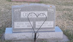
Ruth Mae Kracht Ossenkop
| Birth | : | 21 Sep 1919 Iowa, USA |
| Death | : | 30 Jul 2011 Harlan, Shelby County, Iowa, USA |
| Burial | : | Hayes Township Cemetery, Westside, Crawford County, USA |
| Coordinate | : | 42.0083199, -95.1216583 |
| Description | : | Ruth Mae Ossenkop was born September 21, 1919, the daughter of Amandus and Agnes Shelldorf Kracht. She passed away Saturday, July 30, 2011, at the Elm Crest Retirement Community in Harlan, Iowa, at the age of ninety-one. Ruth was born in Westside, Iowa. She attended Westside Community Schools, graduating with the class of 1936. She was united in marriage to Vernon Ossenkop on October 20, 1938, at St. John Evangelical Church in Westside, Iowa. They made their home on a farm near Vail, Iowa, in Hayes Township. To this union were born five children. Ruth worked hard on the farm, raising and... Read More |
frequently asked questions (FAQ):
-
Where is Ruth Mae Kracht Ossenkop's memorial?
Ruth Mae Kracht Ossenkop's memorial is located at: Hayes Township Cemetery, Westside, Crawford County, USA.
-
When did Ruth Mae Kracht Ossenkop death?
Ruth Mae Kracht Ossenkop death on 30 Jul 2011 in Harlan, Shelby County, Iowa, USA
-
Where are the coordinates of the Ruth Mae Kracht Ossenkop's memorial?
Latitude: 42.0083199
Longitude: -95.1216583
Family Members:
Parent

Spouse
Siblings

Children
Flowers:


Nearby Cemetories:
1. Westside Cemetery
Westside, Crawford County, USA
Coordinate: 42.0602989, -95.0922012
2. Saint Anns Cemetery
Vail, Crawford County, USA
Coordinate: 42.0513992, -95.1868973
3. Vail Cemetery
Vail, Crawford County, USA
Coordinate: 42.0647011, -95.2102966
4. Iowa Township Cemetery
Aspinwall, Crawford County, USA
Coordinate: 41.9216995, -95.1113968
5. Saint Johns Catholic Cemetery
Arcadia, Carroll County, USA
Coordinate: 42.0855406, -95.0341577
6. Sacred Heart Cemetery
Manning, Carroll County, USA
Coordinate: 41.9132500, -95.0540000
7. Saint Augustine Cemetery
Halbur, Carroll County, USA
Coordinate: 42.0066986, -94.9744034
8. Manning Cemetery
Manning, Carroll County, USA
Coordinate: 41.8990000, -95.0620000
9. Arcadia Cemetery
Arcadia Township, Carroll County, USA
Coordinate: 42.1000680, -95.0130550
10. King Cemetery
Vail, Crawford County, USA
Coordinate: 42.1007996, -95.2319031
11. Nishnabotna Cemetery
Manilla, Crawford County, USA
Coordinate: 41.9086952, -95.2464447
12. Mount Olivet Cemetery
Manilla, Crawford County, USA
Coordinate: 41.8922005, -95.2200012
13. Old Catholic Cemetery
Denison, Crawford County, USA
Coordinate: 42.0043983, -95.3189011
14. Holy Angels Cemetery
Carroll County, USA
Coordinate: 42.0014000, -94.9141998
15. Sacred Heart Cemetery
Templeton, Carroll County, USA
Coordinate: 41.9138746, -94.9460994
16. Saint Rose of Lima Cemetery
Denison, Crawford County, USA
Coordinate: 42.0247002, -95.3394012
17. Saint Francis Cemetery
Maple River, Carroll County, USA
Coordinate: 42.0969009, -94.9372025
18. Zion Lutheran Cemetery
Denison, Crawford County, USA
Coordinate: 41.9958000, -95.3450012
19. Crawford Heights Memory Gardens
Denison, Crawford County, USA
Coordinate: 42.0008011, -95.3469009
20. Oakland Cemetery
Denison, Crawford County, USA
Coordinate: 41.9972000, -95.3478012
21. Deloit Cemetery
Deloit, Crawford County, USA
Coordinate: 42.1075325, -95.3136520
22. Washington Township Cemetery
Buck Grove, Crawford County, USA
Coordinate: 41.9354000, -95.3387000
23. Wheatland Cemetery
Carroll County, USA
Coordinate: 42.1814003, -95.0582962
24. Elba Cemetery
Templeton, Carroll County, USA
Coordinate: 41.9068985, -94.9131012