
| Birth | : | 10 Sep 1927 Sutherland, Lincoln County, Nebraska, USA |
| Death | : | 8 Dec 1977 Fort Collins, Larimer County, Colorado, USA |
| Burial | : | Memorial Cemetery, Fremont, Dodge County, USA |
| Coordinate | : | 41.4516210, -96.5058210 |
| Plot | : | C-133-6 |
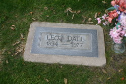
| Description | : | Ruth Marie (Dale) Stout, 50 September 10, 1927 ~ December 8, 1977 Ruth Marie was born September 10, 1927 in Sutherland, Nebraska, to Nora M. (Andrews) and Leo L. Dale. Her father was a brakeman on the steam railroad, and from at least 1935 to 1940, she and her family lived at 1309 Sixth, North Platte, Nebraska. The 1940 US Census lists: Leo L. Dale, 45, head, b. MO Nora M. Dale, 38, wife, b. MO Anna Mae Dale, 17, daughter, b. MO Ruth Marie Dale, 12, daughter, b. NE Lela E. Dale, ... Read More |
frequently asked questions (FAQ):
-
Where is Ruth Marie Dale Stout's memorial?
Ruth Marie Dale Stout's memorial is located at: Memorial Cemetery, Fremont, Dodge County, USA.
-
When did Ruth Marie Dale Stout death?
Ruth Marie Dale Stout death on 8 Dec 1977 in Fort Collins, Larimer County, Colorado, USA
-
Where are the coordinates of the Ruth Marie Dale Stout's memorial?
Latitude: 41.4516210
Longitude: -96.5058210
Family Members:
Parent

Spouse

Siblings
Flowers:


Nearby Cemetories:
1. Memorial Cemetery
Fremont, Dodge County, USA
Coordinate: 41.4516210, -96.5058210
2. First Congregational Church Columbarium
Fremont, Dodge County, USA
Coordinate: 41.4439000, -96.4974300
3. Ridge Cemetery
Fremont, Dodge County, USA
Coordinate: 41.4425011, -96.5231018
4. Calvary Cemetery
Fremont, Dodge County, USA
Coordinate: 41.4435997, -96.5271988
5. Saint James Episcopal Church Columbarium
Fremont, Dodge County, USA
Coordinate: 41.4334370, -96.4944130
6. Critten Barrett Cemetery
Cedar Bluffs, Saunders County, USA
Coordinate: 41.4229110, -96.5577650
7. Hartung Cemetery
Washington County, USA
Coordinate: 41.5182991, -96.4257965
8. Bluffs Trinity Lutheran Cemetery
Fremont, Dodge County, USA
Coordinate: 41.5098080, -96.5973720
9. Maple Grove Cemetery
Cedar Bluffs, Saunders County, USA
Coordinate: 41.3880997, -96.6006012
10. Platteville Cemetery
Saunders County, USA
Coordinate: 41.3506012, -96.5410995
11. Pohocco Lutheran Church Cemetery
Leshara, Saunders County, USA
Coordinate: 41.3462715, -96.5026627
12. Fontanelle Lutheran Cemetery
Fontanelle, Washington County, USA
Coordinate: 41.5384827, -96.4214783
13. Wiegand Cemetery
Cedar Bluffs, Saunders County, USA
Coordinate: 41.3819008, -96.6205978
14. Maple Creek Christian Cemetery
Fremont, Dodge County, USA
Coordinate: 41.5390200, -96.5973600
15. Gods Acre Cemetery
Arlington, Washington County, USA
Coordinate: 41.5060997, -96.3677979
16. Little Flower Cemetery
Pohocco Township, Saunders County, USA
Coordinate: 41.3350860, -96.4834470
17. Arlington Cemetery
Arlington, Washington County, USA
Coordinate: 41.4597015, -96.3392029
18. Johannes Cemetery
Cedar Bluffs, Saunders County, USA
Coordinate: 41.3788986, -96.6438980
19. Union Cemetery
Cedar Bluffs, Saunders County, USA
Coordinate: 41.3513985, -96.6108017
20. Bethel Methodist Cemetery
Dodge County, USA
Coordinate: 41.5583687, -96.6172409
21. Valley Cemetery
Valley, Douglas County, USA
Coordinate: 41.3446999, -96.3794022
22. Colby-Morley Cemetery
Arlington, Washington County, USA
Coordinate: 41.4664050, -96.3126470
23. Saint Marys Cemetery
Saunders County, USA
Coordinate: 41.3932991, -96.6943970
24. Hooper Cemetery
Hooper, Dodge County, USA
Coordinate: 41.6032982, -96.5419006