
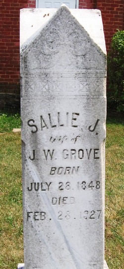
Sallie J. Smiteman Grove
| Birth | : | 28 Jul 1848 |
| Death | : | 28 Feb 1927 South English, Keokuk County, Iowa, USA |
| Burial | : | Boston Cemetery and Crematorium, Boston, Boston Borough, England |
| Coordinate | : | 52.9888100, -0.0273450 |
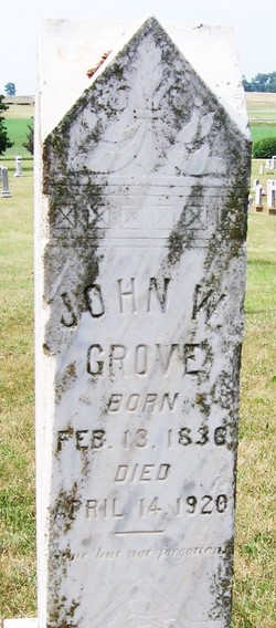
| Description | : | Mrs. Sallie J. Grove, wife of John W. Grove, deceased, of near Waynesboro, Virginia died at the home of her son, W.D. Grove of South English, Iowa. The remains will reach Waynesboro on No. 4, Sunday the 27th, at 11:45am. Funeral will be held from Mt. Vernon Church at 2:30pm Sunday. Valley Virginian of February 25, 1927 Obit courtesy of JLB #47105907. NOTE that the gravestone death date does not match the dates in and of the obit. |
frequently asked questions (FAQ):
-
Where is Sallie J. Smiteman Grove's memorial?
Sallie J. Smiteman Grove's memorial is located at: Boston Cemetery and Crematorium, Boston, Boston Borough, England.
-
When did Sallie J. Smiteman Grove death?
Sallie J. Smiteman Grove death on 28 Feb 1927 in South English, Keokuk County, Iowa, USA
-
Where are the coordinates of the Sallie J. Smiteman Grove's memorial?
Latitude: 52.9888100
Longitude: -0.0273450
Family Members:
Spouse
Children
Flowers:


Nearby Cemetories:
1. Boston Cemetery and Crematorium
Boston, Boston Borough, England
Coordinate: 52.9888100, -0.0273450
2. Boston Centenary Methodist Churchyard
Boston Borough, England
Coordinate: 52.9803214, -0.0241620
3. Holy Trinity Churchyard
Boston, Boston Borough, England
Coordinate: 52.9837160, -0.0150690
4. Black Friars Priory
Boston, Boston Borough, England
Coordinate: 52.9786110, -0.0258330
5. St. Botolph Churchyard
Boston, Boston Borough, England
Coordinate: 52.9785700, -0.0252740
6. Unitarian Burial Ground
Boston, Boston Borough, England
Coordinate: 52.9765987, -0.0212365
7. St. Aiden's Churchyard
Boston Borough, England
Coordinate: 52.9727909, -0.0250366
8. Boston Baptist Cemetery
Boston, Boston Borough, England
Coordinate: 52.9726351, -0.0477945
9. St. Thomas Churchyard
Skirbeck, Boston Borough, England
Coordinate: 52.9649810, -0.0296080
10. Tranquility Gardens
Quesnel, Cariboo Regional District, Canada
Coordinate: 53.0184530, 0.0000000
11. St. Leodegar Churchyard
Wyberton, Boston Borough, England
Coordinate: 52.9480560, -0.0236110
12. Wyberton Cemetery
Wyberton, Boston Borough, England
Coordinate: 52.9480560, -0.0225000
13. St. James Churchyard
Freiston, Boston Borough, England
Coordinate: 52.9738620, 0.0484651
14. St. Peter's Churchyard
Frithville, East Lindsey District, England
Coordinate: 53.0380330, -0.0391600
15. St. Gilbert of Sempringham
Brothertoft, Boston Borough, England
Coordinate: 52.9987500, -0.1090160
16. St Mary's Churchyard
Frampton, Boston Borough, England
Coordinate: 52.9335410, -0.0289950
17. St. Andrew's Churchyard
Butterwick, Boston Borough, England
Coordinate: 52.9837000, 0.0655000
18. Kirton in Holland New Cemetery
Kirton, Boston Borough, England
Coordinate: 52.9361110, -0.0597220
19. Kirton in Holland Old Cemetery
Kirton, Boston Borough, England
Coordinate: 52.9352780, -0.0583330
20. Church of St. Peter and St. Paul
Kirton, Boston Borough, England
Coordinate: 52.9280560, -0.0597220
21. St. Margaret Churchyard
Langrick, East Lindsey District, England
Coordinate: 53.0206370, -0.1214770
22. All Saints Churchyard
Benington, Boston Borough, England
Coordinate: 52.9977010, 0.0803000
23. St. Mary's Churchyard
Old Leake, Boston Borough, England
Coordinate: 53.0311810, 0.0967100
24. St. Paul's Churchyard
Carrington, East Lindsey District, England
Coordinate: 53.0783300, -0.0437200