
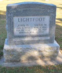
Sallie Martena Johnson Lightfoot
| Birth | : | 8 Mar 1880 Greene County, Iowa, USA |
| Death | : | 26 Feb 1920 Greene County, Iowa, USA |
| Burial | : | Paton Cemetery, Paton, Greene County, USA |
| Coordinate | : | 42.1624985, -94.2433014 |
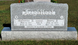
| Inscription | : | Married 17 Mar 1902 to John D. Parents of R. Ray, Lowell & Harry |
| Description | : | Sallie M. Johnson, daughter of Mr. and Mrs. Daniel Johnson, was born near Paton, Iowa, on March 8, 1880. When 16 years of age she was converted and joined the Presbyterian Church at Paton. She graduated from Paton High School in 1898 and taught school for nearly five years, and on March 17, 1903, married John D. Lightfoot. To this union three sons were born, namely, Ray, aged 16; Lowell, aged 9 and Harry, aged 6, all of whom are living. For nearly a year her health was failing, and last December she was sent to... Read More |
frequently asked questions (FAQ):
-
Where is Sallie Martena Johnson Lightfoot's memorial?
Sallie Martena Johnson Lightfoot's memorial is located at: Paton Cemetery, Paton, Greene County, USA.
-
When did Sallie Martena Johnson Lightfoot death?
Sallie Martena Johnson Lightfoot death on 26 Feb 1920 in Greene County, Iowa, USA
-
Where are the coordinates of the Sallie Martena Johnson Lightfoot's memorial?
Latitude: 42.1624985
Longitude: -94.2433014
Family Members:
Parent

Spouse

Siblings
Children
Flowers:


Nearby Cemetories:
1. Paton Cemetery
Paton, Greene County, USA
Coordinate: 42.1624985, -94.2433014
2. Dawson Cemetery
Paton, Greene County, USA
Coordinate: 42.1655998, -94.3283005
3. Renner Cemetery
Boone County, USA
Coordinate: 42.1380420, -94.1256570
4. Lost Grove Cemetery
Harcourt, Webster County, USA
Coordinate: 42.2583008, -94.2331009
5. Swedish Lutheran Church Cemetery
Dayton, Webster County, USA
Coordinate: 42.2175000, -94.1065000
6. Lawn Cemetery
Boone County, USA
Coordinate: 42.1771011, -94.0867996
7. Union Cemetery
Boxholm, Boone County, USA
Coordinate: 42.1369019, -94.0852966
8. Grand Ridge Cemetery
Beaver, Boone County, USA
Coordinate: 42.0786018, -94.1157990
9. Gowrie Township Cemetery
Gowrie, Webster County, USA
Coordinate: 42.2813988, -94.3043976
10. Mount Calvary Cemetery
Grand Junction, Greene County, USA
Coordinate: 42.0266000, -94.2325000
11. Beaver Cemetery
Beaver, Boone County, USA
Coordinate: 42.0462000, -94.1446000
12. Junction Township Cemetery
Grand Junction, Greene County, USA
Coordinate: 42.0236015, -94.2593994
13. Maple Grove Cemetery
Boxholm, Boone County, USA
Coordinate: 42.0793690, -94.0859890
14. Maas Cemetery
Boone County, USA
Coordinate: 42.0908012, -94.0618973
15. Pilot Mound Cemetery
Pilot Mound, Boone County, USA
Coordinate: 42.1636200, -94.0282600
16. Christ the King Catholic Cemetery
Dayton, Webster County, USA
Coordinate: 42.2601929, -94.0727539
17. Dayton Cemetery
Dayton, Webster County, USA
Coordinate: 42.2675000, -94.0755000
18. Highland Township Cemetery
Churdan, Greene County, USA
Coordinate: 42.1518310, -94.4699120
19. Saint Joseph Cemetery
Jefferson, Greene County, USA
Coordinate: 42.0289001, -94.3818970
20. Reading Cemetery
Farnhamville, Calhoun County, USA
Coordinate: 42.2593994, -94.4325027
21. Jefferson Cemetery
Jefferson, Greene County, USA
Coordinate: 42.0133018, -94.3591995
22. Runyan Cemetery
Pilot Mound, Boone County, USA
Coordinate: 42.1749992, -94.0015030
23. Our Saviour Cemetery
Callender, Webster County, USA
Coordinate: 42.3396988, -94.3153000
24. Linn Cemetery
Pilot Mound, Boone County, USA
Coordinate: 42.2045330, -93.9970230