
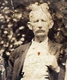
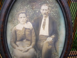
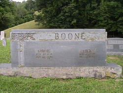

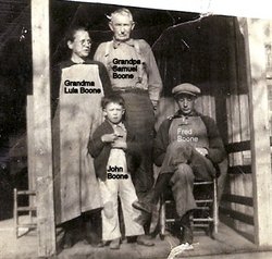
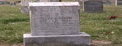
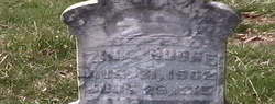
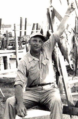
Samuel Boone
| Birth | : | 27 Jul 1848 |
| Death | : | 22 Jan 1930 |
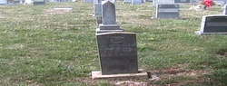
| Burial | : | Rebels Creek Cemetery, Boonford, Mitchell County, USA |
| Coordinate | : | 35.9514008, -82.1697006 |
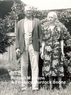
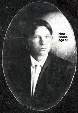
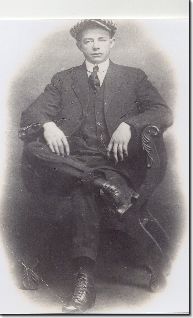
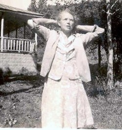
| Description | : | Samuel Boone, was first married to Elizabeth Tolley in 1868. Their children were: John Nelson Boone, born 8/30/1869; Charles Pender Boone, b. 12/11/1872; William Boone, b. 6/14/1875; James (Jim)Boone, b. 7/29/1877, Josephus Boone, b. 3/13/1882; Samuel J. Boone, b. 9/1879; Hanner Boone, their last child b. 5/17/1883. Lula Davis Boone was the second wife of Samuel Boone married about 1885, Samuel having been married to Elizabeth Tolley first. Lula was the mother of Ed Boone, born 10/23/1886; John Nathan Boone, b. 12/5/1889; Milton Boone, b. 9/21/1889; Rosa Bell Boone, b. 1/5/1888; Willard Boone, b. 2/21/1894; Harry Boone, b. 12/18/1895;... Read More |
frequently asked questions (FAQ):
-
Where is Samuel Boone's memorial?
Samuel Boone's memorial is located at: Rebels Creek Cemetery, Boonford, Mitchell County, USA.
-
When did Samuel Boone death?
Samuel Boone death on 22 Jan 1930 in
-
Where are the coordinates of the Samuel Boone's memorial?
Latitude: 35.9514008
Longitude: -82.1697006
Family Members:
Parent
Spouse


Siblings
Children
Flowers:


Nearby Cemetories:
1. Rebels Creek Cemetery
Boonford, Mitchell County, USA
Coordinate: 35.9514008, -82.1697006
2. Kona Baptist Church Cemetery
Kona, Mitchell County, USA
Coordinate: 35.9513790, -82.1838930
3. Silver Cemetery
Mitchell County, USA
Coordinate: 35.9514008, -82.1841965
4. Gouge Cemetery
Bandana, Mitchell County, USA
Coordinate: 35.9692001, -82.1722031
5. Silver Chapel Church Cemetery
Bakersville, Mitchell County, USA
Coordinate: 35.9729170, -82.1773460
6. Double Island Baptist Church Cemetery
Double Island, Yancey County, USA
Coordinate: 35.9572570, -82.2023160
7. Snow Hill Cemetery
Bakersville, Mitchell County, USA
Coordinate: 35.9679600, -82.1402400
8. Edd Young Cemetery
Yancey County, USA
Coordinate: 35.9198600, -82.1834000
9. Big Crabtree Cemetery
Estatoe, Mitchell County, USA
Coordinate: 35.9202285, -82.1490755
10. Hall Cemetery
Double Island, Yancey County, USA
Coordinate: 35.9639300, -82.2120800
11. Fred Young Cemetery
Green Mountain, Yancey County, USA
Coordinate: 35.9396500, -82.2138200
12. Thomas Family Cemetery
Burnsville, Yancey County, USA
Coordinate: 35.9767980, -82.2052420
13. Faith Fellowship Church Cemetery
Yancey County, USA
Coordinate: 35.9169300, -82.1913300
14. Wilson-Rector Hill Cemetery
Double Island, Yancey County, USA
Coordinate: 35.9230000, -82.2092300
15. Hughes Cemetery
Double Island, Yancey County, USA
Coordinate: 35.9286003, -82.2164001
16. Conley Cemetery
Mitchell County, USA
Coordinate: 35.9397011, -82.1168976
17. Thomas Cemetery
Double Island, Yancey County, USA
Coordinate: 35.9900017, -82.1980972
18. Woody Cemetery
Double Island, Yancey County, USA
Coordinate: 35.9807200, -82.2119980
19. Pleasant Grove Cemetery
Burnsville, Yancey County, USA
Coordinate: 35.9836920, -82.2108660
20. Wilson Memorial Cemetery
Bakersville, Mitchell County, USA
Coordinate: 35.9938200, -82.1416200
21. Mine Creek Baptist Church Cemetery
Bakersville, Mitchell County, USA
Coordinate: 35.9995600, -82.1676200
22. Johnson Woody Cemetery
Burnsville, Yancey County, USA
Coordinate: 35.9772100, -82.2204800
23. Ledger Baptist Church Cemetery
Ledger, Mitchell County, USA
Coordinate: 35.9675700, -82.1122500
24. Hughes Jones Cemetery
Green Mountain, Yancey County, USA
Coordinate: 35.9531400, -82.2305800