
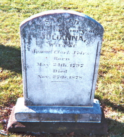
Samuel Clark Veirs
| Birth | : | 24 Jan 1798 |
| Death | : | 8 Nov 1872 Maryland, USA |
| Burial | : | Garfield Cemetery, Spink County, USA |
| Coordinate | : | 44.6622009, -98.5535965 |
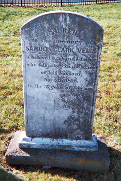
| Inscription | : | Sacred to the memory of Samuel Clark Veirs a beloved husband and father who fell asleep in the arms of his saviour Nov. 8, 1872 in the 75th year of his age |
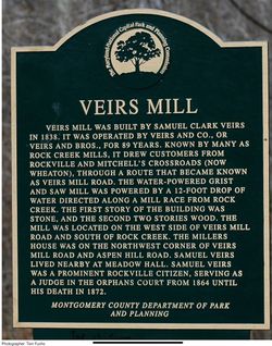
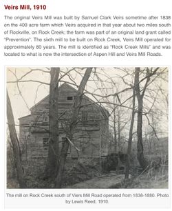
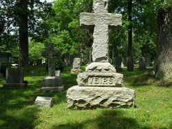
| Description | : | Samuel Clarke Veirs was prominent among the citizens of Rockville for many years. He was born near Dawsonville, Montgomery County, Maryland where he was engaged in the mercantile business with Charles Diffendorffer. In 1819, Samuel Clarke Veirs married Julianna, the youngest sister of his partner. He reined in business in Baltimore until about 1820 when he moved to a farm on Rock Creek just south of Rockville. He named his property "Meadow Hall." He owned and operated a flour and grist mill on Rock Creek for a number of years. Veirs Mill Road was named for the Veirs' family mill.... Read More |
frequently asked questions (FAQ):
-
Where is Samuel Clark Veirs's memorial?
Samuel Clark Veirs's memorial is located at: Garfield Cemetery, Spink County, USA.
-
When did Samuel Clark Veirs death?
Samuel Clark Veirs death on 8 Nov 1872 in Maryland, USA
-
Where are the coordinates of the Samuel Clark Veirs's memorial?
Latitude: 44.6622009
Longitude: -98.5535965
Family Members:
Spouse
Children

Flowers:


Nearby Cemetories:
1. Garfield Cemetery
Spink County, USA
Coordinate: 44.6622009, -98.5535965
2. Bonilla Cemetery
Bonilla, Beadle County, USA
Coordinate: 44.5830994, -98.4835968
3. Saint Johns Cemetery
Tulare, Spink County, USA
Coordinate: 44.7202988, -98.6600037
4. Tulare Cemetery
Tulare, Spink County, USA
Coordinate: 44.7486000, -98.4922028
5. Buffalo Cemetery
Spink County, USA
Coordinate: 44.6918983, -98.6853027
6. Altoona Cemetery
Hitchcock, Beadle County, USA
Coordinate: 44.6108017, -98.4113998
7. Crandon Cemetery
Spink County, USA
Coordinate: 44.7825012, -98.4436035
8. Graceland Cemetery
Tulare, Spink County, USA
Coordinate: 44.7481003, -98.3861008
9. Cottonwood Cemetery
Redfield, Spink County, USA
Coordinate: 44.8078800, -98.6579600
10. Burdette Cemetery
Burdette, Hand County, USA
Coordinate: 44.7002983, -98.7869034
11. Beulah Cemetery
Vayland, Hand County, USA
Coordinate: 44.6060982, -98.8060989
12. Spink Colony Cemetery
Spink Colony, Spink County, USA
Coordinate: 44.7440800, -98.2923800
13. Sunbeam Cemetery
Hand County, USA
Coordinate: 44.6777992, -98.8407974
14. Hillestad Cemetery
Spink County, USA
Coordinate: 44.6944008, -98.2596970
15. Broadland Cemetery
Broadland, Beadle County, USA
Coordinate: 44.5005989, -98.3380966
16. Broadland Catholic Cemetery
Broadland, Beadle County, USA
Coordinate: 44.5005000, -98.3380800
17. Greenlawn Cemetery
Redfield, Spink County, USA
Coordinate: 44.8857994, -98.5164032
18. Saint Bernard Cemetery
Redfield, Spink County, USA
Coordinate: 44.8857994, -98.5139008
19. South Dakota Developmental Center Cemetery
Spink County, USA
Coordinate: 44.8880120, -98.5234880
20. Saint Josephs Catholic Cemetery
Hand County, USA
Coordinate: 44.4574400, -98.7100400
21. Wessington Cemetery
Hand County, USA
Coordinate: 44.4569016, -98.7102966
22. Glendale Colony Cemetery
Spink County, USA
Coordinate: 44.7999900, -98.2856600
23. Guttenberg Cemetery
Spink County, USA
Coordinate: 44.8205986, -98.2972031
24. Poor Farm Cemetery
Frankfort, Spink County, USA
Coordinate: 44.8836350, -98.3591071