
Samuel E Eikenbary
| Birth | : | 15 Jul 1801 Campbell County, Virginia, USA |
| Death | : | 18 Mar 1868 Mynard, Cass County, Nebraska, USA |
| Burial | : | Riverview Cemetery, Northland, Marquette County, USA |
| Coordinate | : | 46.0724983, -87.5994415 |
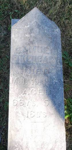
| Inscription | : | Samuel Eikenbary died Mar 19 1868 Aged 66 ys 5 ms 16 ds. |
| Description | : | Samuel E Eikenbary son of Peter Eikenberry Jr and Elizabeth Landis married Martha Crawford on Dec 8 1825 in Ohio. They moved to Plattsmouth area from Danville, Iowa. They owned the land around Pleasant Ridge (Horning) Cemetery. With his cousin Sam Miller he took part in the Gold Rush from 1849 - 1851. He engaged in mining and other ventures. He took a herd of cattle overland to Oregon in 1852. He was a memeber of the first Nebraska Territorial Assembly and of the Constitutional Convention. |
frequently asked questions (FAQ):
-
Where is Samuel E Eikenbary's memorial?
Samuel E Eikenbary's memorial is located at: Riverview Cemetery, Northland, Marquette County, USA.
-
When did Samuel E Eikenbary death?
Samuel E Eikenbary death on 18 Mar 1868 in Mynard, Cass County, Nebraska, USA
-
Where are the coordinates of the Samuel E Eikenbary's memorial?
Latitude: 46.0724983
Longitude: -87.5994415
Family Members:
Parent
Spouse
Siblings

Children
Flowers:


Nearby Cemetories:
1. Riverview Cemetery
Northland, Marquette County, USA
Coordinate: 46.0724983, -87.5994415
2. Forest Home Cemetery
Wells Township, Marquette County, USA
Coordinate: 46.0372009, -87.4449997
3. Whispering Pines Cemetery
Ralph, Dickinson County, USA
Coordinate: 46.1091995, -87.7716980
4. Foster City Cemetery
Foster City, Dickinson County, USA
Coordinate: 45.9635870, -87.7285240
5. Felch Cemetery
Felch, Dickinson County, USA
Coordinate: 45.9925000, -87.8152770
6. Ketola Family Cemetery
Gwinn, Marquette County, USA
Coordinate: 46.2811100, -87.4408300
7. Gwinn Cemetery
Gwinn, Marquette County, USA
Coordinate: 46.2886009, -87.4403000
8. Bakkala Cemetery
Forsyth Township, Marquette County, USA
Coordinate: 46.3236008, -87.5280991
9. Lathrop Cemetery
Maple Ridge Township, Delta County, USA
Coordinate: 46.1486110, -87.2252770
10. Saint Nicholas Cemetery
Saint Nicholas, Delta County, USA
Coordinate: 45.9869440, -87.2258330
11. Hillview Cemetery
McFarland, Marquette County, USA
Coordinate: 46.1803017, -87.2228012
12. Rock Cemetery
Maple Ridge Township, Delta County, USA
Coordinate: 46.0694440, -87.1836110
13. Maple Ridge Cemetery
Rock, Delta County, USA
Coordinate: 46.0638889, -87.1722222
14. Waucedah Township Cemetery
Waucedah Township, Dickinson County, USA
Coordinate: 45.7649994, -87.7339020
15. Saint Michaels Cemetery
Perronville, Menominee County, USA
Coordinate: 45.7952800, -87.3544400
16. Kaltalahti Cemetery
Palmer, Marquette County, USA
Coordinate: 46.3999235, -87.5429445
17. Channing Cemetery
Channing, Dickinson County, USA
Coordinate: 46.1302986, -88.0839005
18. Rosehill East Cemetery
Mansfield, Iron County, USA
Coordinate: 46.0735589, -88.1243176
19. West Branch Township Cemetery
Marquette, Marquette County, USA
Coordinate: 46.3622017, -87.2782974
20. Meyer Township Cemetery
Hermansville, Menominee County, USA
Coordinate: 45.7022018, -87.5927963
21. Spalding Township Cemetery
Spalding, Menominee County, USA
Coordinate: 45.7057991, -87.5227966
22. Norway Township Cemetery
Norway, Dickinson County, USA
Coordinate: 45.7655983, -87.9011002
23. Sands Township Cemetery
Sands, Marquette County, USA
Coordinate: 46.4233040, -87.4037080
24. Flat Rock Cemetery
Escanaba, Delta County, USA
Coordinate: 45.8259000, -87.1880000