
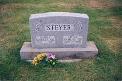
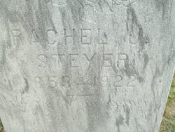
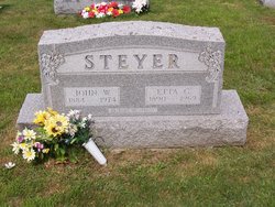
Samuel Granville Steyer
| Birth | : | 17 Apr 1858 Preston County, West Virginia, USA |
| Death | : | 1932 Gorman, Garrett County, Maryland, USA |
| Burial | : | White Church Community Cemetery, Kearney, Garrett County, USA |
| Coordinate | : | 39.3427100, -79.3199400 |
| Inscription | : | FATHER |
frequently asked questions (FAQ):
-
Where is Samuel Granville Steyer's memorial?
Samuel Granville Steyer's memorial is located at: White Church Community Cemetery, Kearney, Garrett County, USA.
-
When did Samuel Granville Steyer death?
Samuel Granville Steyer death on 1932 in Gorman, Garrett County, Maryland, USA
-
Where are the coordinates of the Samuel Granville Steyer's memorial?
Latitude: 39.3427100
Longitude: -79.3199400
Family Members:
Parent
Spouse
Siblings
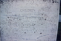
Children

Flowers:


Nearby Cemetories:
1. White Church Community Cemetery
Kearney, Garrett County, USA
Coordinate: 39.3427100, -79.3199400
2. Thompson Cemetery
Oakland, Garrett County, USA
Coordinate: 39.3386100, -79.3184700
3. Harvey-Wilson Cemetery
Garrett County, USA
Coordinate: 39.3325005, -79.3114014
4. White Cemetery
Oakland, Garrett County, USA
Coordinate: 39.3557700, -79.3277900
5. Tasker Family Cemetery
Oakland, Garrett County, USA
Coordinate: 39.3611900, -79.2986500
6. Chisholm-Nydegger Cemetery
Garrett County, USA
Coordinate: 39.3189011, -79.3403015
7. Lish Cemetery
Garrett County, USA
Coordinate: 39.3347015, -79.3561020
8. Oak Grove Cemetery
Gorman, Garrett County, USA
Coordinate: 39.3147011, -79.3531036
9. Wonderly Cemetery
Loch Lynn Heights, Garrett County, USA
Coordinate: 39.3767014, -79.3692017
10. King Cemetery
Loch Lynn Heights, Garrett County, USA
Coordinate: 39.3894005, -79.3480988
11. Mayle Cemetery
Garrett County, USA
Coordinate: 39.3981018, -79.3317032
12. Pope Cemetery
Gorman, Garrett County, USA
Coordinate: 39.2870120, -79.3473470
13. Moon Cemetery
Deer Park, Garrett County, USA
Coordinate: 39.3958015, -79.2814026
14. Moreland Cemetery
Garrett County, USA
Coordinate: 39.2952995, -79.3703003
15. Pleasant Valley Cemetery
Oakland, Garrett County, USA
Coordinate: 39.3717003, -79.3906021
16. Beckman Cemetery
Garrett County, USA
Coordinate: 39.3293991, -79.4000015
17. Paughs Cemetery
Garrett County, USA
Coordinate: 39.3869019, -79.2593994
18. Old Bayard Cemetery
Grant County, USA
Coordinate: 39.2776740, -79.3435850
19. Schlabach Cemetery
Gortner, Garrett County, USA
Coordinate: 39.3482800, -79.4117000
20. Rehobeth Cemetery
Mount Storm, Grant County, USA
Coordinate: 39.3164540, -79.2330010
21. Bayard Cemetery
Bayard, Grant County, USA
Coordinate: 39.2728004, -79.3447037
22. Lower Cemetery
Oakland, Garrett County, USA
Coordinate: 39.3716890, -79.4179470
23. Weber Family Cemetery
Oakland, Garrett County, USA
Coordinate: 39.4017020, -79.3959960
24. Gortner Cemetery
Gortner, Garrett County, USA
Coordinate: 39.3530998, -79.4272003