
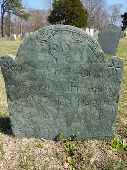

Samuel Hopkins
| Birth | : | 30 Aug 1724 Harwich, Barnstable County, Massachusetts, USA |
| Death | : | 15 Nov 1761 Harwich, Barnstable County, Massachusetts, USA |
| Burial | : | Burr Oak Cemetery, Athens, Calhoun County, USA |
| Coordinate | : | 42.0844002, -85.2461014 |
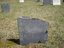
| Inscription | : | age 38 |
| Description | : | b. 30 Aug 1724 Harwich, Barnstable Co., Massachusetts d. Harwich, Barnstable Co., Massachusetts son of Nathaniel & Mercy (Mayo) Hopkins husband of Mehitable (Snow) Hopkins *** 8-23 2021 seems as though no one can agree on who the mother is: Mother is incorrect. Mary Mayo Hopkins, 83118372, is not the mother of Samuel Hopkins. See text nariative with Samuel Hopkins, which states his mother is: Mercy Mayo Hopkins, born 1688 - 1765. Mary Mayo Hopkins, was marriecd to Joseph Hopkins, 1688-1772. additional information courtesy of Arthur Ridley #47235113 |
frequently asked questions (FAQ):
-
Where is Samuel Hopkins's memorial?
Samuel Hopkins's memorial is located at: Burr Oak Cemetery, Athens, Calhoun County, USA.
-
When did Samuel Hopkins death?
Samuel Hopkins death on 15 Nov 1761 in Harwich, Barnstable County, Massachusetts, USA
-
Where are the coordinates of the Samuel Hopkins's memorial?
Latitude: 42.0844002
Longitude: -85.2461014
Family Members:
Parent
Siblings
Flowers:


Nearby Cemetories:
1. Burr Oak Cemetery
Athens, Calhoun County, USA
Coordinate: 42.0844002, -85.2461014
2. Old Burg Cemetery
Athens, Calhoun County, USA
Coordinate: 42.0916660, -85.2208330
3. North Sherwood Cemetery
Sherwood, Branch County, USA
Coordinate: 42.0611000, -85.2481003
4. Indian Cemetery
Athens, Calhoun County, USA
Coordinate: 42.1126140, -85.2647750
5. Stimpson Cemetery
Athens, Calhoun County, USA
Coordinate: 42.1380000, -85.2520000
6. Factoryville Cemetery
Factoryville, St. Joseph County, USA
Coordinate: 42.0505560, -85.3069460
7. Walker Cemetery
Athens, Calhoun County, USA
Coordinate: 42.1352770, -85.2119440
8. North Athens Cemetery
Athens, Calhoun County, USA
Coordinate: 42.1507420, -85.2557810
9. Blossom Road Cemetery
Sherwood Township, Branch County, USA
Coordinate: 42.0160380, -85.2737760
10. Sherwood Cemetery
Sherwood, Branch County, USA
Coordinate: 42.0066660, -85.2386110
11. Riverside Cemetery
Union City, Branch County, USA
Coordinate: 42.0734200, -85.1351700
12. South Fulton Cemetery
Fulton, Kalamazoo County, USA
Coordinate: 42.1119610, -85.3524830
13. North Fulton Cemetery
Fulton, Kalamazoo County, USA
Coordinate: 42.1302986, -85.3422012
14. Abscota Cemetery
Burlington, Calhoun County, USA
Coordinate: 42.1452770, -85.1583330
15. Mather-Voyce Cemetery
East Leroy, Calhoun County, USA
Coordinate: 42.1736110, -85.1986110
16. Congregational Cemetery
East Leroy, Calhoun County, USA
Coordinate: 42.1876060, -85.2574470
17. Banta Cemetery
Leonidas, St. Joseph County, USA
Coordinate: 41.9922220, -85.3125000
18. Beard Cemetery
Leonidas, St. Joseph County, USA
Coordinate: 42.0711090, -85.3916700
19. Burlington Township Cemetery
Burlington, Calhoun County, USA
Coordinate: 42.1013889, -85.0905560
20. McAuley Cemetery
Leonidas Township, St. Joseph County, USA
Coordinate: 41.9916992, -85.3450012
21. Barrington Cemetery
Burlington, Calhoun County, USA
Coordinate: 42.1461110, -85.1091660
22. Covey Road Amish Cemetery
Leonidas, St. Joseph County, USA
Coordinate: 41.9990290, -85.3613490
23. Old Burlington Cemetery
Burlington, Calhoun County, USA
Coordinate: 42.1059360, -85.0833820
24. Harrison Cemetery
Climax, Kalamazoo County, USA
Coordinate: 42.1797200, -85.3644400