
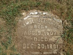
Samuel Slaughter
| Birth | : | 10 Aug 1807 Virginia, USA |
| Death | : | 20 Dec 1881 |
| Burial | : | Saint John Cemetery, Washington, Daviess County, USA |
| Coordinate | : | 38.6761017, -87.1806030 |
| Description | : | The Slave Hunter: On June 2, 1843, nine slaves working on the property of Ruel Daggs (born in Virginia and a farmer) near Luray, MO left the homestead. Daggs had not been mean to them but he was living in an area where some people frowned on slavery and he was thinking of selling them into the South. The slaves said they were afraid of being sold and decided to head north to freedom instead. Daggs and his sons hired two slave hunters to track them and bring them back. One of the men was James McClure and the... Read More |
frequently asked questions (FAQ):
-
Where is Samuel Slaughter's memorial?
Samuel Slaughter's memorial is located at: Saint John Cemetery, Washington, Daviess County, USA.
-
When did Samuel Slaughter death?
Samuel Slaughter death on 20 Dec 1881 in
-
Where are the coordinates of the Samuel Slaughter's memorial?
Latitude: 38.6761017
Longitude: -87.1806030
Family Members:
Parent
Spouse
Siblings

Children
Flowers:


Nearby Cemetories:
1. Saint John Cemetery
Washington, Daviess County, USA
Coordinate: 38.6761017, -87.1806030
2. Pioneer Park
Washington, Daviess County, USA
Coordinate: 38.6604100, -87.1689340
3. Old City Cemetery
Washington, Daviess County, USA
Coordinate: 38.6600520, -87.1681280
4. Old Catholic City Cemetery
Washington, Daviess County, USA
Coordinate: 38.6606470, -87.1665600
5. Hawkins Cemetery
Washington, Daviess County, USA
Coordinate: 38.6622009, -87.2039032
6. D.A.R. Cemetery
Washington, Daviess County, USA
Coordinate: 38.6484860, -87.1730030
7. Oak Grove Cemetery
Washington, Daviess County, USA
Coordinate: 38.6610985, -87.2114029
8. Old Sugarland Cemetery
Washington, Daviess County, USA
Coordinate: 38.6965300, -87.1538540
9. Daviess County Farm Cemetery
Washington, Daviess County, USA
Coordinate: 38.6960100, -87.1377700
10. Colbert Cemetery
Daviess County, USA
Coordinate: 38.6364980, -87.1922230
11. Taylor Lyons Cemetery
Washington, Daviess County, USA
Coordinate: 38.6778670, -87.2361940
12. Sugarland Memory Gardens
Washington, Daviess County, USA
Coordinate: 38.7184400, -87.1662600
13. Maysville Cemetery
Washington, Daviess County, USA
Coordinate: 38.6479492, -87.2246170
14. Maple Valley Switch Cemetery
Washington, Daviess County, USA
Coordinate: 38.6286300, -87.1920300
15. Veale Creek Baptist Church Cemetery
Washington, Daviess County, USA
Coordinate: 38.6343002, -87.1338654
16. Old Bethel Cemetery
Washington, Daviess County, USA
Coordinate: 38.6161930, -87.1896000
17. Union Cemetery
South Washington, Daviess County, USA
Coordinate: 38.6130900, -87.1843300
18. New Veale Creek Cemetery
Washington, Daviess County, USA
Coordinate: 38.6246720, -87.1233310
19. Fresh Start Mennonite Cemetery
Washington, Daviess County, USA
Coordinate: 38.6453910, -87.1021810
20. Bethel Cemetery
Washington, Daviess County, USA
Coordinate: 38.6027985, -87.1806030
21. Bethany Cemetery
Washington, Daviess County, USA
Coordinate: 38.6544991, -87.0867004
22. Veale Cemetery
South Washington, Daviess County, USA
Coordinate: 38.6047000, -87.2186000
23. Antioch Cemetery
Montgomery, Daviess County, USA
Coordinate: 38.7058910, -87.0872280
24. Providence Mennonite Cemetery
Montgomery, Daviess County, USA
Coordinate: 38.6568200, -87.0790400