
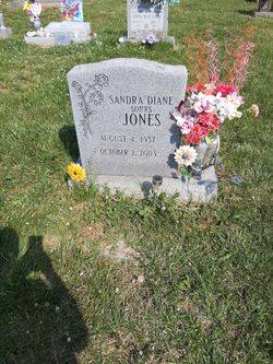
Sandra Diane “Sandy” Sours Jones
| Birth | : | 4 Aug 1957 |
| Death | : | 2 Oct 2003 |
| Burial | : | Sheldon Cemetery, Canton, Wayne County, USA |
| Coordinate | : | 42.2807999, -83.4764023 |
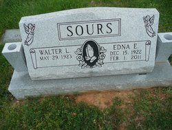
| Description | : | Sandra Diane "Sandy" Sours Jones was escorted by angels to heaven Thursday, Oct. 2, 2003. She passed away at Rockingham Memorial Hospital from heart failure. She was born Aug. 4, 1957. Sandy was a high school graduate and attended Blue Ridge Community College, where she received a degree in dental assistance. She was employed by Rockingham Memorial Hospital, where she was a switchboard operator. Sandy will be sadly missed by her parents, Walter Lee and Edna Earl Buracker Sours. She leaves behind a loving and devoted husband, James Edward Jones Jr. They united their love Feb. 21, 2003. Sandy was... Read More |
frequently asked questions (FAQ):
-
Where is Sandra Diane “Sandy” Sours Jones's memorial?
Sandra Diane “Sandy” Sours Jones's memorial is located at: Sheldon Cemetery, Canton, Wayne County, USA.
-
When did Sandra Diane “Sandy” Sours Jones death?
Sandra Diane “Sandy” Sours Jones death on 2 Oct 2003 in
-
Where are the coordinates of the Sandra Diane “Sandy” Sours Jones's memorial?
Latitude: 42.2807999
Longitude: -83.4764023
Family Members:
Parent
Flowers:


Nearby Cemetories:
1. Sheldon Cemetery
Canton, Wayne County, USA
Coordinate: 42.2807999, -83.4764023
2. Downer Cemetery
Canton, Wayne County, USA
Coordinate: 42.2790950, -83.4447670
3. Denton Cemetery
Denton, Wayne County, USA
Coordinate: 42.2580330, -83.5291420
4. Cherry Hill Cemetery
Canton, Wayne County, USA
Coordinate: 42.3050270, -83.5380249
5. Knollwood Memorial Park Cemetery
Canton, Wayne County, USA
Coordinate: 42.3146057, -83.5311966
6. Saint Michael Lutheran Church Memorial Gardens
Canton, Wayne County, USA
Coordinate: 42.3345340, -83.4779590
7. Tyler Street Cemetery
Van Buren Township, Wayne County, USA
Coordinate: 42.2372017, -83.4300003
8. Kirk of Our Savior Memorial Garden
Westland, Wayne County, USA
Coordinate: 42.3102798, -83.4002838
9. Chubb Cemetery
Westland, Wayne County, USA
Coordinate: 42.3325005, -83.4242020
10. Trinity Memorial Gardens
Belleville, Wayne County, USA
Coordinate: 42.2164459, -83.4849243
11. Old Wayne Cemetery
Wayne, Wayne County, USA
Coordinate: 42.2831345, -83.3874130
12. Kinyon Cemetery
Canton, Wayne County, USA
Coordinate: 42.3424988, -83.5274963
13. Soop-Pleasantview Cemetery
Van Buren Township, Wayne County, USA
Coordinate: 42.2165642, -83.5229645
14. Hillside Cemetery
Belleville, Wayne County, USA
Coordinate: 42.2094002, -83.4978027
15. Spencer Cemetery
Ypsilanti, Washtenaw County, USA
Coordinate: 42.2493134, -83.5685806
16. Saint Mary Cemetery
Wayne, Wayne County, USA
Coordinate: 42.2821999, -83.3728027
17. Free Church Cemetery
Superior Township, Washtenaw County, USA
Coordinate: 42.3199997, -83.5672226
18. Romulus Memorial Cemetery
Romulus, Wayne County, USA
Coordinate: 42.2287300, -83.3962310
19. Glenwood Cemetery
Wayne, Wayne County, USA
Coordinate: 42.2883820, -83.3696760
20. Sunset Hills Cemetery
Ypsilanti, Washtenaw County, USA
Coordinate: 42.3196983, -83.5767822
21. Cadillac Memorial Gardens West
Westland, Wayne County, USA
Coordinate: 42.3280983, -83.3768997
22. Saint Johns Episcopal Church Memorial Garden
Plymouth, Wayne County, USA
Coordinate: 42.3691960, -83.4806110
23. The Hill Cemetery
Plymouth, Wayne County, USA
Coordinate: 42.3730540, -83.4690570
24. Riverside Cemetery
Plymouth, Wayne County, USA
Coordinate: 42.3722000, -83.4527969