
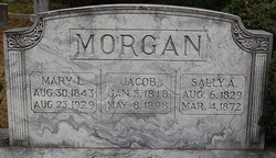
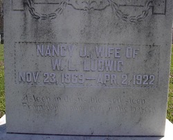
Sarah Amanda “Sally” Hodge Morgan
| Birth | : | 6 Aug 1829 |
| Death | : | 4 Mar 1872 |
| Burial | : | Carinya Gardens, Mount Gambier, Mount Gambier City, Australia |
| Coordinate | : | -37.8370330, 140.7494970 |
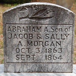
| Description | : | Marriage records found show that Sarah A Hodge was married to Jacob Morgan on 07 July 1851 in Rowan, North Carolina according to Contributor: LAD (50056583) 1st wife of Jacob Morgan, Married 4/10/1851 in Rowan Co., NC--not sure of source here Child: John Franklin Morgan (1860-1939) |
frequently asked questions (FAQ):
-
Where is Sarah Amanda “Sally” Hodge Morgan's memorial?
Sarah Amanda “Sally” Hodge Morgan's memorial is located at: Carinya Gardens, Mount Gambier, Mount Gambier City, Australia.
-
When did Sarah Amanda “Sally” Hodge Morgan death?
Sarah Amanda “Sally” Hodge Morgan death on 4 Mar 1872 in
-
Where are the coordinates of the Sarah Amanda “Sally” Hodge Morgan's memorial?
Latitude: -37.8370330
Longitude: 140.7494970
Family Members:
Spouse

Children
Flowers:


Nearby Cemetories:
1. Pioneer Park
Mount Gambier, Mount Gambier City, Australia
Coordinate: -37.8348290, 140.7840010
2. Mieschel Park
Mount Gambier, Mount Gambier City, Australia
Coordinate: -37.8374980, 140.7855890
3. Lake Terrace Cemetery
Mount Gambier, Mount Gambier City, Australia
Coordinate: -37.8425950, 140.7854720
4. Port MacDonnell Lighthouse Cemetery
Port MacDonnell, District Council of Grant, Australia
Coordinate: -38.0558330, 140.6630560
5. Kalangadoo Cemetery
Kalangadoo, Wattle Range Council, Australia
Coordinate: -37.5694190, 140.7045780
6. Nelson Cemetery
Nelson, Glenelg Shire, Australia
Coordinate: -38.0359977, 141.0123516
7. Strathdownie Cemetery
Strathdownie, Glenelg Shire, Australia
Coordinate: -37.7174000, 141.1676280
8. Millicent Cemetery
Millicent, Wattle Range Council, Australia
Coordinate: -37.6184335, 140.3770980
9. Dartmoor Cemetery
Dartmoor, Glenelg Shire, Australia
Coordinate: -37.9148220, 141.2491380
10. Heathfield Cemetery
Lake Mundi, Glenelg Shire, Australia
Coordinate: -37.5713233, 141.1436213
11. Penola Cemetery
Penola, Wattle Range Council, Australia
Coordinate: -37.4009210, 140.8362800
12. Drik Drik Cemetery
Drik Drik, Glenelg Shire, Australia
Coordinate: -37.9858333, 141.2952778
13. Penola Old Cemetery
Penola, Wattle Range Council, Australia
Coordinate: -37.3670740, 140.8412400
14. Casterton Old Cemetery
Casterton, Glenelg Shire, Australia
Coordinate: -37.5948850, 141.3700380
15. Casterton Cemetery
Casterton, Glenelg Shire, Australia
Coordinate: -37.5992440, 141.4088270
16. Digby Cemetery
Digby, Glenelg Shire, Australia
Coordinate: -37.8196840, 141.5040810
17. Sandford Cemetery
Sandford, Glenelg Shire, Australia
Coordinate: -37.6290998, 141.4562576
18. Dergholm Cemetery
Dergholm, West Wimmera Shire, Australia
Coordinate: -37.3717520, 141.2253000
19. Rifle Ranges Pastoral Run
Digby, Glenelg Shire, Australia
Coordinate: -37.7813184, 141.5104222
20. Merino Cemetery
Merino, Glenelg Shire, Australia
Coordinate: -37.6908180, 141.5434050
21. Beachport Cemetery
Beachport, Wattle Range Council, Australia
Coordinate: -37.4725340, 140.0475120
22. Hotspur Cemetery
Hotspur, Glenelg Shire, Australia
Coordinate: -37.9297580, 141.5866650
23. Corkhill Station Cemetery
Cape Bridgewater, Glenelg Shire, Australia
Coordinate: -38.3451060, 141.4092120
24. Cape Bridgewater Cemetery
Cape Bridgewater Lower, Glenelg Shire, Australia
Coordinate: -38.3396480, 141.4298350