
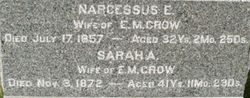
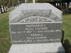
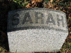
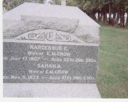
Sarah Ann “Sally” Wall Crow
| Birth | : | 26 Nov 1830 |
| Death | : | 3 Nov 1872 |
| Burial | : | Riverside Cemetery, Ironwood, Gogebic County, USA |
| Coordinate | : | 46.4599476, -90.1829530 |
| Plot | : | Row 24 |
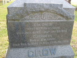
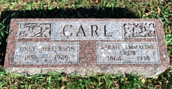
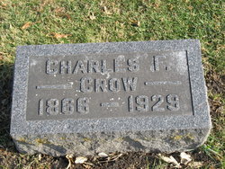
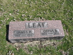
| Description | : | She was married to: Joseph J Ratcliff [1/9/1850]( 1 child) - burial unknown, probably Cedar County, Iowa Addison T Green[2/5/1854] (2 children) - burial unknown, probably LaSalle County, Illinois Edward Millis Crow[12/8/1860] (7 children). Etwina Ratcliff(m. Elias M Rumple) 1852 [on 1860 census last name is Green] Mary A Green 1857 [on 1870 census last name is Crow] David Green 1859 Jefferson D Crow 1861 Nelson M Crow 1863 Sarah Emmaline Crow (m. Oney Carl) 1864 Charles Franklin Crow 1867 Garrison M Crow 1868 Louis N Crow 1870 Orpha Belle Crow (m. James Leaf) 1860 United States... Read More |
frequently asked questions (FAQ):
-
Where is Sarah Ann “Sally” Wall Crow's memorial?
Sarah Ann “Sally” Wall Crow's memorial is located at: Riverside Cemetery, Ironwood, Gogebic County, USA.
-
When did Sarah Ann “Sally” Wall Crow death?
Sarah Ann “Sally” Wall Crow death on 3 Nov 1872 in
-
Where are the coordinates of the Sarah Ann “Sally” Wall Crow's memorial?
Latitude: 46.4599476
Longitude: -90.1829530
Family Members:
Parent
Spouse
Siblings

Children
Flowers:


Nearby Cemetories:
1. Riverside Cemetery
Ironwood, Gogebic County, USA
Coordinate: 46.4599476, -90.1829530
2. Saint Mary's Cemetery
Hurley, Iron County, USA
Coordinate: 46.4443200, -90.1812600
3. Sharey Zedek Cemetery
Hurley, Iron County, USA
Coordinate: 46.4433280, -90.1824760
4. Hurley Cemetery
Hurley, Iron County, USA
Coordinate: 46.4429800, -90.1813800
5. Sunset Acres Cemetery
Ironwood, Gogebic County, USA
Coordinate: 46.5189490, -90.1660820
6. Hillcrest Cemetery
Bessemer, Gogebic County, USA
Coordinate: 46.4855995, -90.0456009
7. Hillside Cemetery
Iron Belt, Iron County, USA
Coordinate: 46.4000015, -90.3377991
8. Lakeside Cemetery
Wakefield, Gogebic County, USA
Coordinate: 46.4674988, -89.9456024
9. Lake View Cemetery
Saxon, Iron County, USA
Coordinate: 46.5010986, -90.4227982
10. Calvary Cemetery
Upson, Iron County, USA
Coordinate: 46.3774986, -90.4080963
11. Greenwood Cemetery
Upson, Iron County, USA
Coordinate: 46.3778000, -90.4094009
12. Indian Cemetery
Ironwood, Gogebic County, USA
Coordinate: 46.6058330, -90.3305560
13. Edgewood Cemetery
Gurney, Iron County, USA
Coordinate: 46.4972000, -90.5077972
14. Saint Johns Lutheran Cemetery
Mellen, Ashland County, USA
Coordinate: 46.3923800, -90.5690100
15. Mercer Cemetery
Mercer, Iron County, USA
Coordinate: 46.1575012, -90.0539017
16. Winchester Memorial Cemetery
Winchester, Vilas County, USA
Coordinate: 46.2452300, -89.8359900
17. Marenisco Township Cemetery
Marenisco, Gogebic County, USA
Coordinate: 46.3847220, -89.6969440
18. Mellen Union Cemetery
Mellen, Ashland County, USA
Coordinate: 46.3294800, -90.6621800
19. Presque Isle Cemetery
Presque Isle, Vilas County, USA
Coordinate: 46.2442017, -89.7624969
20. Shanty Boy Hill Cemetery
Presque Isle, Vilas County, USA
Coordinate: 46.2473520, -89.7279540
21. Mount Hope Cemetery
High Bridge, Ashland County, USA
Coordinate: 46.3859700, -90.7353300
22. Bad River Cemetery
Odanah, Ashland County, USA
Coordinate: 46.5992100, -90.7208900
23. Pine Lawn Cemetery
Manitowish Waters, Vilas County, USA
Coordinate: 46.1241250, -89.8659110
24. Greenwood Cemetery
Morse, Ashland County, USA
Coordinate: 46.2224846, -90.6509399