Sarah Catherine Mitts Roper
| Birth | : | 3 Mar 1858 Iowa County, Wisconsin, USA |
| Death | : | 21 Aug 1911 Pueblo, Pueblo County, Colorado, USA |
| Burial | : | Green Lawn Cemetery, Columbus, Franklin County, USA |
| Coordinate | : | 39.9403000, -83.0325012 |
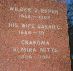
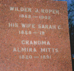
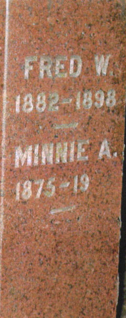
| Description | : | Daughter of Azariah and Almira Harrington Mitts. She first married Wilder J Roper, her first cousin, on September 11, 1873 in Barron, Barron County, Wisconsin. They had six children while living in Wisconsin. Four of them passed away by 1884 before they moved to Pierce County, Nebraska. Her son Fred passed away on December 23, 1898 at the age of 16 in Pierce, Pierce County, Nebraska. Her husband Wilder passed away November 2,1903. After his death she married his brother Charles L. Roper on September 25, 1905 in Pierce County, Nebraska. They... Read More |
frequently asked questions (FAQ):
-
Where is Sarah Catherine Mitts Roper's memorial?
Sarah Catherine Mitts Roper's memorial is located at: Green Lawn Cemetery, Columbus, Franklin County, USA.
-
When did Sarah Catherine Mitts Roper death?
Sarah Catherine Mitts Roper death on 21 Aug 1911 in Pueblo, Pueblo County, Colorado, USA
-
Where are the coordinates of the Sarah Catherine Mitts Roper's memorial?
Latitude: 39.9403000
Longitude: -83.0325012
Family Members:
Parent
Spouse
Siblings
Children
Flowers:
Nearby Cemetories:
1. Green Lawn Cemetery
Columbus, Franklin County, USA
Coordinate: 39.9403000, -83.0325012
2. Temple Israel Cemetery
Columbus, Franklin County, USA
Coordinate: 39.9464836, -83.0222626
3. Mount Calvary Cemetery
Columbus, Franklin County, USA
Coordinate: 39.9480800, -83.0223800
4. Green Lawn Abbey Mausoleum
Columbus, Franklin County, USA
Coordinate: 39.9406128, -83.0160370
5. State of Ohio Feebleminded Cemetery
Columbus, Franklin County, USA
Coordinate: 39.9507217, -83.0421677
6. Old Franklinton Cemetery
Columbus, Franklin County, USA
Coordinate: 39.9631004, -83.0222015
7. Union Methodist Cemetery
Columbus, Franklin County, USA
Coordinate: 39.9192162, -83.0499039
8. State New Insane Cemetery
Columbus, Franklin County, USA
Coordinate: 39.9626990, -83.0539690
9. Firedog Kelly Memorial
Columbus, Franklin County, USA
Coordinate: 39.9207490, -83.0605300
10. State Old Insane and Penal Cemetery
Columbus, Franklin County, USA
Coordinate: 39.9649277, -83.0575180
11. Peters Cemetery
Grove City, Franklin County, USA
Coordinate: 39.9141650, -83.0561990
12. State of Ohio Asylum for the Insane Cemetery
Columbus, Franklin County, USA
Coordinate: 39.9631194, -83.0632411
13. Camp Chase Confederate Cemetery
Columbus, Franklin County, USA
Coordinate: 39.9439011, -83.0761032
14. FCSO K9 Cemetery
Franklin County, USA
Coordinate: 39.9078130, -83.0204420
15. Trinity Episcopal Church Columbarium
Columbus, Franklin County, USA
Coordinate: 39.9622866, -82.9976831
16. Saint Joseph Roman Catholic Cathedral Crypt
Columbus, Franklin County, USA
Coordinate: 39.9632530, -82.9946442
17. Old North Graveyard
Columbus, Franklin County, USA
Coordinate: 39.9721000, -83.0041000
18. Westminster Thurber Memorial Garden
Columbus, Franklin County, USA
Coordinate: 39.9760740, -83.0111940
19. Columbus City South Cemetery
Columbus, Franklin County, USA
Coordinate: 39.9158040, -82.9902310
20. Franklin County Pest House Cemetery
Columbus, Franklin County, USA
Coordinate: 39.9141460, -82.9909060
21. Livingston Park Cemetery
Columbus, Franklin County, USA
Coordinate: 39.9514008, -82.9787979
22. Columbus Catholic Cemetery
Columbus, Franklin County, USA
Coordinate: 39.9692850, -82.9877510
23. Marsh Cemetery
Grove City, Franklin County, USA
Coordinate: 39.8986030, -83.0599720
24. First Community Church Memorial Garden
Marble Cliff, Franklin County, USA
Coordinate: 39.9834080, -83.0577350


