
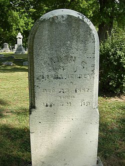

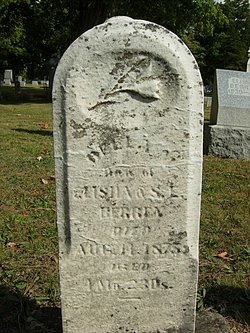
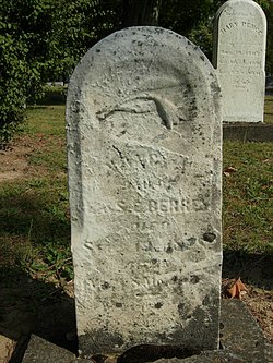
Sarah E Poorman Berry
| Birth | : | 18 Jul 1846 Ohio, USA |
| Death | : | 29 Dec 1887 Champaign County, Ohio, USA |
| Burial | : | Saint Joseph Cemetery, Bath, Grafton County, USA |
| Coordinate | : | 44.1803017, -72.0524979 |
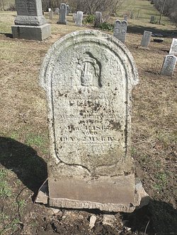
| Description | : | Inscription: Wife of Elisha Berrey -- Aged 41y, 5m, 11d St Paris December 2, 1887 Mrs Elisha Berry died of consumption last Thursday, aged 41 years. She was Mr Bery's second wife, and left him with 4 children. Funeral is at the Baptist Church, Thursday. Rev Murray officiating, interment at Evergreen Cemetery, St Paris. |
frequently asked questions (FAQ):
-
Where is Sarah E Poorman Berry's memorial?
Sarah E Poorman Berry's memorial is located at: Saint Joseph Cemetery, Bath, Grafton County, USA.
-
When did Sarah E Poorman Berry death?
Sarah E Poorman Berry death on 29 Dec 1887 in Champaign County, Ohio, USA
-
Where are the coordinates of the Sarah E Poorman Berry's memorial?
Latitude: 44.1803017
Longitude: -72.0524979
Family Members:
Parent

Spouse
Siblings
Children
Flowers:


Nearby Cemetories:
1. Saint Joseph Cemetery
Bath, Grafton County, USA
Coordinate: 44.1803017, -72.0524979
2. Carbee District Cemetery
Bath, Grafton County, USA
Coordinate: 44.1881040, -72.0521310
3. Carbee Cemetery
Bath, Grafton County, USA
Coordinate: 44.1724640, -72.0466980
4. Wells River Cemetery
Wells River, Orange County, USA
Coordinate: 44.1535988, -72.0547028
5. Bedel Cemetery
Bath, Grafton County, USA
Coordinate: 44.2075000, -72.0455560
6. Old Scotch Cemetery
Ryegate, Caledonia County, USA
Coordinate: 44.1969000, -72.0928600
7. Boltonville Cemetery
Boltonville, Orange County, USA
Coordinate: 44.1575012, -72.0877991
8. Manchester Family Cemetery
Ryegate, Caledonia County, USA
Coordinate: 44.2153625, -72.0713120
9. Blue Mountain Cemetery
Ryegate Corner, Caledonia County, USA
Coordinate: 44.2081000, -72.1058700
10. West Bath Cemetery
Bath, Grafton County, USA
Coordinate: 44.1750930, -71.9865080
11. Pine Grove Cemetery
Woodsville, Grafton County, USA
Coordinate: 44.1380997, -72.0188980
12. Upper Smith Road Cemetery
Bath, Grafton County, USA
Coordinate: 44.2202780, -72.0075000
13. Pinehurst Cemetery
Ryegate, Caledonia County, USA
Coordinate: 44.1856003, -72.1280975
14. Hillside Cemetery
South Ryegate, Caledonia County, USA
Coordinate: 44.1846800, -72.1336200
15. Bath Village Cemetery
Bath, Grafton County, USA
Coordinate: 44.1693500, -71.9617800
16. Jefferson Hill Cemetery
Newbury, Orange County, USA
Coordinate: 44.1658400, -72.1424200
17. Pettyboro District Cemetery
Pettyboro, Grafton County, USA
Coordinate: 44.2038310, -71.9620880
18. Horse Meadow Cemetery
North Haverhill, Grafton County, USA
Coordinate: 44.1068880, -72.0405500
19. Horse Meadow Annex Cemetery
North Haverhill, Grafton County, USA
Coordinate: 44.1056820, -72.0408260
20. Monroe Village Cemetery
Monroe, Grafton County, USA
Coordinate: 44.2558400, -72.0427900
21. Moulton Hill Cemetery
Lyman, Grafton County, USA
Coordinate: 44.2457400, -71.9862900
22. Swiftwater Cemetery
Bath, Grafton County, USA
Coordinate: 44.1303400, -71.9574300
23. McIndoe Falls Cemetery
Barnet, Caledonia County, USA
Coordinate: 44.2685400, -72.0724900
24. Town House Cemetery
Newbury Center, Orange County, USA
Coordinate: 44.1066322, -72.1256943