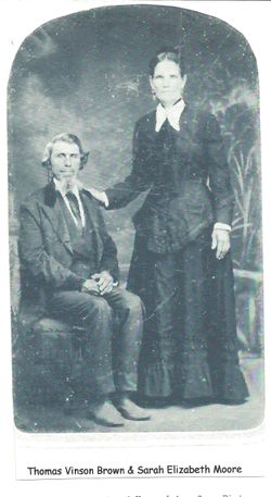
Sarah Elizabeth Moore Brown
| Birth | : | Mar 1832 Tennessee, USA |
| Death | : | 28 May 1911 Valentine, Cherry County, Nebraska, USA |
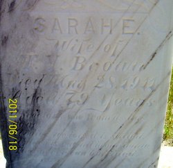
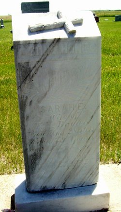
| Burial | : | Green Mound Cemetery, Leola, McPherson County, USA |
| Coordinate | : | 45.7094002, -98.9317017 |
| Plot | : | Block 25, Lot 4 |
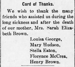
| Description | : | Daughter of William H. Moore and Mary "Polly" Moore. Mrs. Elizabeth Brown , mother of Mrs. George, Mrs. Hudson, Mrs. McCrea, Mrs. Eaton and Henry Brown, died Sunday morning at the home of her daughter Mrs. George in Valentine. She was taken to Sparks Monday where she was laid beside her husband who preceded her about six years ago. Mrs. Brown was getting quite old and feeble. The Democrat extends sympathy to the bereaved relatives. ==================== Valentine Democrat (Valentine, NE), Thursday, June 8, 1911; pg. 8 |
frequently asked questions (FAQ):
-
Where is Sarah Elizabeth Moore Brown's memorial?
Sarah Elizabeth Moore Brown's memorial is located at: Green Mound Cemetery, Leola, McPherson County, USA.
-
When did Sarah Elizabeth Moore Brown death?
Sarah Elizabeth Moore Brown death on 28 May 1911 in Valentine, Cherry County, Nebraska, USA
-
Where are the coordinates of the Sarah Elizabeth Moore Brown's memorial?
Latitude: 45.7094002
Longitude: -98.9317017
Family Members:
Parent
Spouse
Siblings
Children
Flowers:
Nearby Cemetories:
1. Green Mound Cemetery
Leola, McPherson County, USA
Coordinate: 45.7094002, -98.9317017
2. Our Lady of Perpetual Help Cemetery
Leola, McPherson County, USA
Coordinate: 45.7296500, -98.9292400
3. Saint Hyacinth Cemetery #2
Leola, McPherson County, USA
Coordinate: 45.7813300, -98.8502900
4. Saint Hyacinth Cemetery
Leola, McPherson County, USA
Coordinate: 45.7823700, -98.8462400
5. Grassland Colony Cemetery
Westport, Brown County, USA
Coordinate: 45.6666240, -98.7876150
6. Deerfield Colony Cemetery
Ipswich, Edmunds County, USA
Coordinate: 45.5894523, -98.8988255
7. Long Lake Colony Cemetery
Long Lake Colony, McPherson County, USA
Coordinate: 45.6080400, -98.8232200
8. Wetonka Cemetery
Wetonka, McPherson County, USA
Coordinate: 45.6211800, -98.7794300
9. Truesdell Gravesite
Wetonka, McPherson County, USA
Coordinate: 45.6206885, -98.7668775
10. Hoffnungs Cemetery
McPherson County, USA
Coordinate: 45.8398800, -99.0508100
11. Willow Creek Cemetery
Brown County, USA
Coordinate: 45.7370000, -98.7135300
12. Arena Valley Cemetery
Arena Township, McPherson County, USA
Coordinate: 45.7516400, -99.1491600
13. Hoffnungs Gemeinde Cemetery
McPherson County, USA
Coordinate: 45.8396988, -99.0650024
14. Rueb Cemetery
McPherson County, USA
Coordinate: 45.7097600, -99.2023600
15. Leola Cemetery
Leola, McPherson County, USA
Coordinate: 45.7237000, -99.2107500
16. Spring Creek Colony Cemetery
Forbes, Dickey County, USA
Coordinate: 45.9072960, -98.8813220
17. Saron Cemetery
McPherson County, USA
Coordinate: 45.8973000, -99.0367600
18. Gienger Cemetery
McPherson County, USA
Coordinate: 45.8851500, -99.0741300
19. New Straasburg Cemetery
Edmunds County, USA
Coordinate: 45.4977989, -98.8824997
20. Emmanuel Lutheran Cemetery
Long Lake, McPherson County, USA
Coordinate: 45.6693600, -99.2427200
21. Ehpresman Cemetery
McPherson County, USA
Coordinate: 45.9077988, -99.0744019
22. Pembrook Cemetery
Edmunds County, USA
Coordinate: 45.5127983, -98.7842026
23. Lutheran Cemetery
Leola, McPherson County, USA
Coordinate: 45.7235300, -99.2634100
24. Immanuel Lutheran Cemetery
Long Lake, McPherson County, USA
Coordinate: 45.8723800, -99.1801900

