
| Birth | : | 9 Apr 1870 Surry County, North Carolina, USA |
| Death | : | 16 Mar 1946 Surry County, North Carolina, USA |
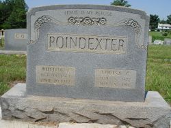
| Burial | : | Prairie Home Cemetery, Holdrege, Phelps County, USA |
| Coordinate | : | 40.4547005, -99.3491974 |
| Description | : | She married her second cousin. On 19 January 1896 when Sarah Frances "Fannie" was 25, she married James M. "Jim" WOOD , son of Samuel "Sam" R. WOOD (May 1841 - 1912) & Rebecca J. SPRINKLE (11 November 1844 - 6 April 1937), in Surry County, North Carolina. Her parents were William Jiles and Letitia Stanley Poindexter. Paternal grandparents were Alexander and Sarah P. Douglas Poindexter. Maternal grandparents were Jesse Stanley (he started Bear Creek Baptist Church) and Sarah Wilmoth Stanley. (Recorded by: K. Ned Beasley, h/o Teresa Sizemore Beasley, 2nd cousin 3 times removed)([email protected]) |
frequently asked questions (FAQ):
-
Where is Sarah Frances Poindexter Wood's memorial?
Sarah Frances Poindexter Wood's memorial is located at: Prairie Home Cemetery, Holdrege, Phelps County, USA.
-
When did Sarah Frances Poindexter Wood death?
Sarah Frances Poindexter Wood death on 16 Mar 1946 in Surry County, North Carolina, USA
-
Where are the coordinates of the Sarah Frances Poindexter Wood's memorial?
Latitude: 40.4547005
Longitude: -99.3491974
Family Members:
Parent

Spouse
Siblings
Children
Flowers:


Nearby Cemetories:
1. Prairie Home Cemetery
Holdrege, Phelps County, USA
Coordinate: 40.4547005, -99.3491974
2. Bethel Cemetery
Phelps County, USA
Coordinate: 40.4463997, -99.3031006
3. Zion Swedish Methodist Cemetery
Phelps County, USA
Coordinate: 40.3792000, -99.3202972
4. Industry Cemetery
Atlanta, Phelps County, USA
Coordinate: 40.4071999, -99.4419022
5. Moses Hill Cemetery
Loomis, Phelps County, USA
Coordinate: 40.5104490, -99.4388600
6. Fridhem Cemetery
Funk, Phelps County, USA
Coordinate: 40.4678001, -99.2174988
7. Magill Cemetery
Phelps County, USA
Coordinate: 40.5539017, -99.2850037
8. Immanuel Lutheran Cemetery
Ragan, Harlan County, USA
Coordinate: 40.3352750, -99.3205050
9. Loomis Cemetery
Loomis, Phelps County, USA
Coordinate: 40.4801860, -99.5128300
10. Salem Methodist Church Cemetery
Axtell, Kearney County, USA
Coordinate: 40.4528000, -99.1790000
11. Antelope Cemetery
Ragan, Harlan County, USA
Coordinate: 40.3356018, -99.2557983
12. Pleasant Hill Cemetery
Axtell, Kearney County, USA
Coordinate: 40.4870000, -99.1235000
13. Wilcox Cemetery
Wilcox, Kearney County, USA
Coordinate: 40.3657990, -99.1511002
14. Shaw Cemetery
Phelps County, USA
Coordinate: 40.4303017, -99.5781021
15. Bethphage Cemetery
Axtell, Kearney County, USA
Coordinate: 40.4882750, -99.1190130
16. Freewater Cemetery
Ragan, Harlan County, USA
Coordinate: 40.3083000, -99.2071991
17. Saint Johns Cemetery
Franklin County, USA
Coordinate: 40.3222008, -99.1631012
18. Bethany Cemetery
Axtell, Kearney County, USA
Coordinate: 40.4665413, -99.0843201
19. Mound Valley Cemetery
Blaine Township, Kearney County, USA
Coordinate: 40.5849341, -99.1428820
20. Williamsburg Cemetery
Phelps County, USA
Coordinate: 40.6490290, -99.4543150
21. Keene Cemetery
Keene, Kearney County, USA
Coordinate: 40.4227700, -99.0747900
22. Keene Family Cemetery
Keene, Kearney County, USA
Coordinate: 40.4270500, -99.0658900
23. Sandstrom Cemetery
Phelps County, USA
Coordinate: 40.5983009, -99.5661011
24. Platte Valley Cemetery
Phelps County, USA
Coordinate: 40.6425018, -99.5028000