
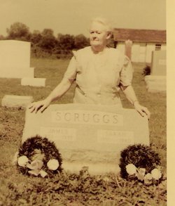
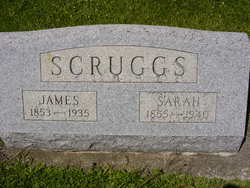
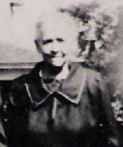

Sarah Francis “Sallie” Miller Scruggs
| Birth | : | 30 Oct 1855 Augusta County, Virginia, USA |
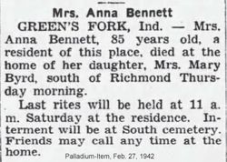
| Death | : | 15 Jan 1940 Greens Fork, Wayne County, Indiana, USA |
| Burial | : | Calvary Cemetery, Fremont, Dodge County, USA |
| Coordinate | : | 41.4435997, -96.5271988 |
| Plot | : | 064 N 1/2 |
| Inscription | : | Wife of James |
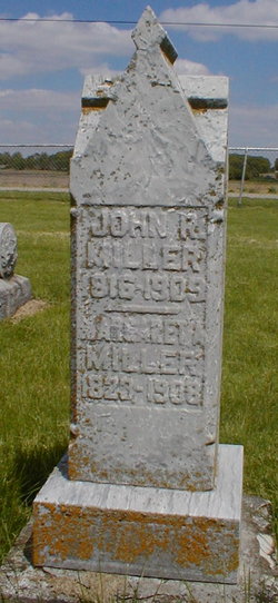
| Description | : | Siblings: John William, Nevada Anngerella, Mary L., George Washington, Margaret, Andrew E., Samuel Houston, Robert Beauregard, Savina, Alvin Rice, unknown child Marriage: 18 December 1879 in Marlinton, Pocahantas County, West Virginia Sarah was born in Virginia before West Virginia was founded. She said she was born in West Virginia but that is because of where they lived when West Virginia was founded in 1863. |
frequently asked questions (FAQ):
-
Where is Sarah Francis “Sallie” Miller Scruggs's memorial?
Sarah Francis “Sallie” Miller Scruggs's memorial is located at: Calvary Cemetery, Fremont, Dodge County, USA.
-
When did Sarah Francis “Sallie” Miller Scruggs death?
Sarah Francis “Sallie” Miller Scruggs death on 15 Jan 1940 in Greens Fork, Wayne County, Indiana, USA
-
Where are the coordinates of the Sarah Francis “Sallie” Miller Scruggs's memorial?
Latitude: 41.4435997
Longitude: -96.5271988
Family Members:
Parent
Spouse

Siblings

Children


Flowers:


Nearby Cemetories:
1. Calvary Cemetery
Fremont, Dodge County, USA
Coordinate: 41.4435997, -96.5271988
2. Ridge Cemetery
Fremont, Dodge County, USA
Coordinate: 41.4425011, -96.5231018
3. Memorial Cemetery
Fremont, Dodge County, USA
Coordinate: 41.4516210, -96.5058210
4. First Congregational Church Columbarium
Fremont, Dodge County, USA
Coordinate: 41.4439000, -96.4974300
5. Saint James Episcopal Church Columbarium
Fremont, Dodge County, USA
Coordinate: 41.4334370, -96.4944130
6. Critten Barrett Cemetery
Cedar Bluffs, Saunders County, USA
Coordinate: 41.4229110, -96.5577650
7. Maple Grove Cemetery
Cedar Bluffs, Saunders County, USA
Coordinate: 41.3880997, -96.6006012
8. Bluffs Trinity Lutheran Cemetery
Fremont, Dodge County, USA
Coordinate: 41.5098080, -96.5973720
9. Wiegand Cemetery
Cedar Bluffs, Saunders County, USA
Coordinate: 41.3819008, -96.6205978
10. Platteville Cemetery
Saunders County, USA
Coordinate: 41.3506012, -96.5410995
11. Pohocco Lutheran Church Cemetery
Leshara, Saunders County, USA
Coordinate: 41.3462715, -96.5026627
12. Hartung Cemetery
Washington County, USA
Coordinate: 41.5182991, -96.4257965
13. Johannes Cemetery
Cedar Bluffs, Saunders County, USA
Coordinate: 41.3788986, -96.6438980
14. Maple Creek Christian Cemetery
Fremont, Dodge County, USA
Coordinate: 41.5390200, -96.5973600
15. Union Cemetery
Cedar Bluffs, Saunders County, USA
Coordinate: 41.3513985, -96.6108017
16. Little Flower Cemetery
Pohocco Township, Saunders County, USA
Coordinate: 41.3350860, -96.4834470
17. Fontanelle Lutheran Cemetery
Fontanelle, Washington County, USA
Coordinate: 41.5384827, -96.4214783
18. Bethel Methodist Cemetery
Dodge County, USA
Coordinate: 41.5583687, -96.6172409
19. Gods Acre Cemetery
Arlington, Washington County, USA
Coordinate: 41.5060997, -96.3677979
20. Saint Marys Cemetery
Saunders County, USA
Coordinate: 41.3932991, -96.6943970
21. Arlington Cemetery
Arlington, Washington County, USA
Coordinate: 41.4597015, -96.3392029
22. Valley Cemetery
Valley, Douglas County, USA
Coordinate: 41.3446999, -96.3794022
23. Green Mound Cemetery
Saunders County, USA
Coordinate: 41.2855988, -96.5250015
24. Hooper Cemetery
Hooper, Dodge County, USA
Coordinate: 41.6032982, -96.5419006