
| Birth | : | 10 Feb 1758 Littleton, Middlesex County, Massachusetts, USA |
| Death | : | 25 Jan 1815 Littleton, Middlesex County, Massachusetts, USA |
| Burial | : | Wolf Creek Community Cemetery, Oglala Lakota County, USA |
| Coordinate | : | 43.0405750, -102.3966490 |
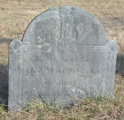
| Inscription | : | Erected In memory of Mrs. Sarah Hartwell wife of Mr. Daniel Hartwell who died [rest of stone buried] |
| Description | : | Daughter of Captain Thomas Hartwell and Mary Hoar. Wife of Daniel Hartwell. They were married in Littleton, MA, on June 27, 1782. Children (b. in Littleton) Thomas, Apr. 7, 1783 - Susannah, May 8, 1785 - Sep. 19, 1848 Sally, Nov. 15, 1788 - Daniel, Apr. 13, 1800 - ______________ Littleton Town Records, birth, Pg 73 Sarah Hartwell Daughter of Capt. Thomas Hartwell Deceased and Mary Hartwell his widow born February ye 10th 1758. Littleton Town Records, marriage, pg 221, 230 Littleton Town Records, pg 353 (Deaths and Burials from the Church Records) "1815, January... Read More |
frequently asked questions (FAQ):
-
Where is Sarah Hartwell Hartwell's memorial?
Sarah Hartwell Hartwell's memorial is located at: Wolf Creek Community Cemetery, Oglala Lakota County, USA.
-
When did Sarah Hartwell Hartwell death?
Sarah Hartwell Hartwell death on 25 Jan 1815 in Littleton, Middlesex County, Massachusetts, USA
-
Where are the coordinates of the Sarah Hartwell Hartwell's memorial?
Latitude: 43.0405750
Longitude: -102.3966490
Family Members:
Parent
Spouse

Siblings
Children
Flowers:


Nearby Cemetories:
1. Wolf Creek Community Cemetery
Oglala Lakota County, USA
Coordinate: 43.0405750, -102.3966490
2. Spotted Bear Family Cemetery
Denby, Oglala Lakota County, USA
Coordinate: 43.0608200, -102.3376600
3. Native American Cemetery
Oglala, Oglala Lakota County, USA
Coordinate: 43.0886002, -102.3550034
4. Lamont Cemetery
Wounded Knee, Oglala Lakota County, USA
Coordinate: 43.1006012, -102.4107971
5. Wounded Knee Monument
Pine Ridge, Oglala Lakota County, USA
Coordinate: 43.1410300, -102.3619600
6. Sacred Heart Catholic Cemetery
Wounded Knee, Oglala Lakota County, USA
Coordinate: 43.1445912, -102.3657458
7. Messiah Episcopal Cemetery
Wounded Knee, Oglala Lakota County, USA
Coordinate: 43.1499300, -102.3779400
8. Presbyterian Cemetery
Wounded Knee, Oglala Lakota County, USA
Coordinate: 43.1503300, -102.3781000
9. Pine Ridge Presbyterian Cemetery
Pine Ridge, Oglala Lakota County, USA
Coordinate: 43.0235200, -102.5506200
10. Holy Cross Cemetery
Pine Ridge, Oglala Lakota County, USA
Coordinate: 43.0194016, -102.5503006
11. Saint Aloysius Cemetery
Sheridan County, USA
Coordinate: 42.9015500, -102.4025500
12. White Clay Cemetery
Rushville, Sheridan County, USA
Coordinate: 42.9732820, -102.5667230
13. Red Cloud Cemetery
Pine Ridge, Oglala Lakota County, USA
Coordinate: 43.0776839, -102.5837514
14. Saint Paul Cemetery
Porcupine, Oglala Lakota County, USA
Coordinate: 43.1863700, -102.4290800
15. Bethel Cemetery
Sheridan County, USA
Coordinate: 42.9011002, -102.3208008
16. Holy Jumping Eagle Family Cemetery
Manderson, Oglala Lakota County, USA
Coordinate: 43.2028590, -102.4513820
17. Feather on Head Cemetery
Oglala Lakota County, USA
Coordinate: 43.0311012, -102.1611023
18. Cortier Family Cemetery
Oglala Lakota County, USA
Coordinate: 43.1160000, -102.6210000
19. Black Tail Deer Family Cemetery
Manderson, Oglala Lakota County, USA
Coordinate: 43.2258400, -102.4787900
20. Saint James Cemetery
Oglala Lakota County, USA
Coordinate: 43.1356010, -102.6397018
21. Tashnke-Ko-Ki-Pa-Pi Cemetery
Oglala Lakota County, USA
Coordinate: 43.1222000, -102.6560974
22. Our Lady of Lourdes Catholic Cemetery
Porcupine, Oglala Lakota County, USA
Coordinate: 43.2448200, -102.3376500
23. Porcupine Presbyterian Cemetery
Porcupine, Oglala Lakota County, USA
Coordinate: 43.2395138, -102.3090627
24. Holly Cemetery
Rushville, Sheridan County, USA
Coordinate: 42.8575120, -102.5370990