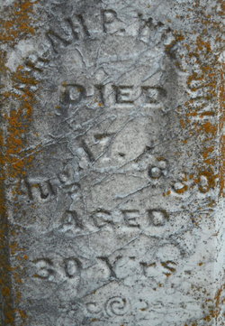
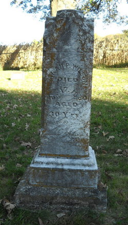
Sarah Jane Perlina Hodges Wilson
| Birth | : | 17 Aug 1850 Shelbyville, Shelby County, Indiana, USA |
| Death | : | 17 Aug 1880 Cedar Falls, Black Hawk County, Iowa, USA |
| Burial | : | Middlewood United Church Cemetery, Middlewood, Lunenburg County, Canada |
| Coordinate | : | 44.2251700, -64.5803800 |
| Description | : | 1st wife of William P. Wilson. They were married December 09, 1869 in Black Hawk County, Iowa. She was the mother of four children. After her death, her husband remarried and moved to Weippe, Clearwater County, Idaho. |
frequently asked questions (FAQ):
-
Where is Sarah Jane Perlina Hodges Wilson's memorial?
Sarah Jane Perlina Hodges Wilson's memorial is located at: Middlewood United Church Cemetery, Middlewood, Lunenburg County, Canada.
-
When did Sarah Jane Perlina Hodges Wilson death?
Sarah Jane Perlina Hodges Wilson death on 17 Aug 1880 in Cedar Falls, Black Hawk County, Iowa, USA
-
Where are the coordinates of the Sarah Jane Perlina Hodges Wilson's memorial?
Latitude: 44.2251700
Longitude: -64.5803800
Family Members:
Flowers:
Nearby Cemetories:
1. Middlewood United Church Cemetery
Middlewood, Lunenburg County, Canada
Coordinate: 44.2251700, -64.5803800
2. Crouses Settlement Cemetery
Italy Cross, Lunenburg County, Canada
Coordinate: 44.2643100, -64.5756600
3. Danesville Old Cemetery
Danesville, Queens County, Canada
Coordinate: 44.1944380, -64.6173580
4. Danesville New Cemetery
Danesville, Queens County, Canada
Coordinate: 44.1943080, -64.6176870
5. Italy Cross United Church Cemetery
Italy Cross, Lunenburg County, Canada
Coordinate: 44.2583600, -64.5323810
6. St Mathias Anglican Cemetery
Italy Cross, Lunenburg County, Canada
Coordinate: 44.2594000, -64.5326600
7. Croft Cemetery
Danesville, Queens County, Canada
Coordinate: 44.1883100, -64.6242070
8. Christ Evangelical Lutheran Cemetery
Camperdown, Lunenburg County, Canada
Coordinate: 44.2740299, -64.6094169
9. Crousetown Community Cemetery
Crousetown, Lunenburg County, Canada
Coordinate: 44.2575000, -64.4875000
10. New Charleston Cemetery
Charleston, Queens County, Canada
Coordinate: 44.1686880, -64.6520780
11. Crouse Cemetery
Crousetown, Lunenburg County, Canada
Coordinate: 44.2672222, -64.4897222
12. Canadee Cemetery
Broad Cove, Lunenburg County, Canada
Coordinate: 44.1941320, -64.4806380
13. Anglican Church Cemetery
Crousetown, Lunenburg County, Canada
Coordinate: 44.2519444, -64.4758333
14. Forest Hill Cemetery
Broad Cove, Lunenburg County, Canada
Coordinate: 44.1725000, -64.4963890
15. Hillside Cemetery
Broad Cove, Lunenburg County, Canada
Coordinate: 44.1722220, -64.4961110
16. Pine Grove Cemetery
Cherry Hill, Lunenburg County, Canada
Coordinate: 44.1680560, -64.5013890
17. Mayflower Hill Cemetery
Cherry Hill, Lunenburg County, Canada
Coordinate: 44.1688890, -64.5000000
18. Woodlawn Cemetery
Cherry Hill, Lunenburg County, Canada
Coordinate: 44.1691670, -64.4994440
19. Saint Matthew's Presbyterian Cemetery
Conquerall Mills, Lunenburg County, Canada
Coordinate: 44.3019440, -64.5419440
20. Old Charleston Cemetery
Charleston, Queens County, Canada
Coordinate: 44.1672620, -64.6611070
21. Conquerall Mills Lutheran Church Cemetery
Conquerall Mills, Lunenburg County, Canada
Coordinate: 44.3022220, -64.5413880
22. Saint Michael's Cemetery
Petite Rivière Bridge, Lunenburg County, Canada
Coordinate: 44.2377780, -64.4655560
23. First Settlers Cemetery
Broad Cove, Lunenburg County, Canada
Coordinate: 44.1827780, -64.4802780
24. Oakhill Cemetery
Conquerall Mills, Lunenburg County, Canada
Coordinate: 44.3058333, -64.5327777


