
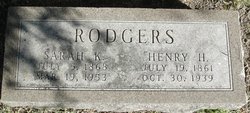
Sarah K Fretz Rodgers
| Birth | : | 5 Jul 1868 Medina County, Ohio, USA |
| Death | : | 19 Mar 1953 Newton, Harvey County, Kansas, USA |
| Burial | : | Jerusalem Cemetery, Elloree, Orangeburg County, USA |
| Coordinate | : | 33.5102340, -80.5447570 |
| Plot | : | 026-2 |
| Description | : | Rodgers, --- Sarah K., daughter of Eli H. and Esther (Koppes) Fretz, was born in Steamtown, Ohio, Medina County, July 5, 1868; passed away at the home of her daughter Cora, Newton, Kans., March 19, 1953; aged 84 y. 8 m. 14 d. At the age of twelve she came to Kansas with her parents and lived in this community the rest of her life with the exception of a few years spent in Oklahoma. At 22 years of age she was baptized and became a member of the Pennsylvania Mennonite Church. On Aug. 5, 1885, she was married Henry... Read More |
frequently asked questions (FAQ):
-
Where is Sarah K Fretz Rodgers's memorial?
Sarah K Fretz Rodgers's memorial is located at: Jerusalem Cemetery, Elloree, Orangeburg County, USA.
-
When did Sarah K Fretz Rodgers death?
Sarah K Fretz Rodgers death on 19 Mar 1953 in Newton, Harvey County, Kansas, USA
-
Where are the coordinates of the Sarah K Fretz Rodgers's memorial?
Latitude: 33.5102340
Longitude: -80.5447570
Family Members:
Parent
Spouse

Siblings

Children
Flowers:


Nearby Cemetories:
1. Jerusalem Cemetery
Elloree, Orangeburg County, USA
Coordinate: 33.5102340, -80.5447570
2. Mount Hebron Baptist Church Cemetery
Santee, Orangeburg County, USA
Coordinate: 33.5028570, -80.5381980
3. New Faith Community Church Cemetery
Elloree, Orangeburg County, USA
Coordinate: 33.5229150, -80.5477570
4. Hart Graveyard
Holly Hill, Orangeburg County, USA
Coordinate: 33.4918320, -80.5470820
5. Browning Branch Cemetery
Elloree, Orangeburg County, USA
Coordinate: 33.5231820, -80.5632140
6. Whitmore, Avinger, Norris, Felder Cemetery
Elloree, Orangeburg County, USA
Coordinate: 33.4870530, -80.5532600
7. Parlerville A.M.E. Church Cemetery
Santee, Orangeburg County, USA
Coordinate: 33.5208030, -80.5039540
8. Mount Pisgah Church Cemetery
Santee, Orangeburg County, USA
Coordinate: 33.5182200, -80.5027480
9. Saluda Baptist Church Cemetery
Elloree, Orangeburg County, USA
Coordinate: 33.4757900, -80.5597300
10. Fellowship of Praise
Santee, Orangeburg County, USA
Coordinate: 33.4934970, -80.5052100
11. Ark of God Cemetery
Santee, Orangeburg County, USA
Coordinate: 33.4630210, -80.5558220
12. Magrill Family Cemetery
Calhoun County, USA
Coordinate: 33.5601790, -80.5354270
13. Granger Baptist Church Cemetery
Elloree, Orangeburg County, USA
Coordinate: 33.4909840, -80.6030410
14. Gresham Cemetery
Orangeburg County, USA
Coordinate: 33.4906006, -80.6031036
15. Antioch Cemetery
Santee, Orangeburg County, USA
Coordinate: 33.4599991, -80.5258026
16. Smith-Dantzler Cemetery
Elloree, Orangeburg County, USA
Coordinate: 33.4941130, -80.6052520
17. Oak Grove Baptist Church Cemetery
Santee, Orangeburg County, USA
Coordinate: 33.4586400, -80.5296220
18. Trinity Lutheran Church Cemetery
Elloree, Orangeburg County, USA
Coordinate: 33.5603720, -80.5659850
19. McGrew Cemetery
Elloree, Orangeburg County, USA
Coordinate: 33.4859880, -80.6027150
20. Bookhart Cemetery
Elloree, Orangeburg County, USA
Coordinate: 33.5485992, -80.5924988
21. Chapel Hill Baptist Church Cemetery
Santee, Orangeburg County, USA
Coordinate: 33.4899690, -80.4829530
22. Hungerpiller Family Cemetery
Elloree, Orangeburg County, USA
Coordinate: 33.5049010, -80.6123380
23. Dantzler Family Cemetery
Elloree, Orangeburg County, USA
Coordinate: 33.4762456, -80.6037355
24. Immanuel Free Will Baptist Church and Cemetery
Santee, Orangeburg County, USA
Coordinate: 33.4621430, -80.5007070