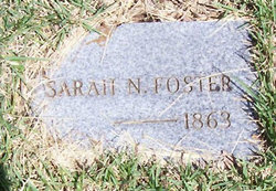
Sarah N. “Sally” Tally Foster
| Birth | : | 13 Aug 1816 Tennessee, USA |
| Death | : | 1863 St. Clair County, Missouri, USA |
| Burial | : | West Cemetery, Litchfield, Litchfield County, USA |
| Coordinate | : | 41.7383003, -73.1980972 |
| Description | : | Sarah was buried at Gray Mill Cemetery which was later moved to Wright's Creek Cemetery. Other information about her from our geneology book "The Tally Ho Trail". She married John Watkins Perkins on December 14, 1835 and he died ca 1845. They had no children. Sarah married 2nd ca. 1846 to James Foster, Jr., after Sarah died he married Amanda Kincade Tally, the widow of George Alexander Tall. INFORMATION PROVIDED BY JEANIE. |
frequently asked questions (FAQ):
-
Where is Sarah N. “Sally” Tally Foster's memorial?
Sarah N. “Sally” Tally Foster's memorial is located at: West Cemetery, Litchfield, Litchfield County, USA.
-
When did Sarah N. “Sally” Tally Foster death?
Sarah N. “Sally” Tally Foster death on 1863 in St. Clair County, Missouri, USA
-
Where are the coordinates of the Sarah N. “Sally” Tally Foster's memorial?
Latitude: 41.7383003
Longitude: -73.1980972
Family Members:
Parent
Spouse
Siblings
Children
Flowers:
Nearby Cemetories:
1. West Cemetery
Litchfield, Litchfield County, USA
Coordinate: 41.7383003, -73.1980972
2. Saint Anthony Cemetery
Litchfield, Litchfield County, USA
Coordinate: 41.7380409, -73.1982956
3. Saint Michaels Parish Memorial Garden
Litchfield, Litchfield County, USA
Coordinate: 41.7460500, -73.1887600
4. First Congregational Church Memorial Garden
Litchfield, Litchfield County, USA
Coordinate: 41.7479470, -73.1880910
5. East Cemetery
Litchfield, Litchfield County, USA
Coordinate: 41.7482070, -73.1813800
6. Bantam Burying Ground
Bantam, Litchfield County, USA
Coordinate: 41.7250900, -73.2322083
7. Our Lady of Grace Cemetery
Bantam, Litchfield County, USA
Coordinate: 41.7242250, -73.2325500
8. Farband Cemetery
Morris, Litchfield County, USA
Coordinate: 41.6890182, -73.1839447
9. Morris Burying Ground
Morris, Litchfield County, USA
Coordinate: 41.6883300, -73.1865400
10. Headquarters Cemetery
Litchfield, Litchfield County, USA
Coordinate: 41.7517014, -73.2643967
11. Footville Burying Ground
Morris, Litchfield County, USA
Coordinate: 41.6820602, -73.2374191
12. Milton Cemetery
Litchfield, Litchfield County, USA
Coordinate: 41.7691994, -73.2782974
13. Hillside Cemetery
Torrington, Litchfield County, USA
Coordinate: 41.7871819, -73.1269608
14. Saint Francis Cemetery
Torrington, Litchfield County, USA
Coordinate: 41.7839012, -73.1149979
15. Scoville Cemetery
Harwinton, Litchfield County, USA
Coordinate: 41.7557983, -73.0942001
16. Old Middle Street Cemetery
Goshen, Litchfield County, USA
Coordinate: 41.8181000, -73.2205963
17. Northfield Cemetery
Northfield, Litchfield County, USA
Coordinate: 41.6972008, -73.1031036
18. Trinity Episcopal Church Memorial Garden
Torrington, Litchfield County, USA
Coordinate: 41.8017470, -73.1225010
19. Collins Cemetery
Goshen, Litchfield County, USA
Coordinate: 41.8238983, -73.1928024
20. Bentley Cemetery
Goshen, Litchfield County, USA
Coordinate: 41.8210869, -73.2316971
21. Center Cemetery
Torrington, Litchfield County, USA
Coordinate: 41.8041992, -73.1196976
22. Old Saint Francis Cemetery
Torrington, Litchfield County, USA
Coordinate: 41.8017349, -73.1154404
23. West Torrington Cemetery
Torrington, Litchfield County, USA
Coordinate: 41.8241997, -73.1669006
24. West Goshen Cemetery
West Goshen, Litchfield County, USA
Coordinate: 41.8133011, -73.2636032


