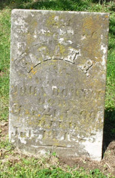
Sarah R Keele Howell
| Birth | : | 21 Mar 1800 Missouri, USA |
| Death | : | 13 Jul 1825 St. Charles County, Missouri, USA |
| Burial | : | Vinje Cemetery, Bottineau, Bottineau County, USA |
| Coordinate | : | 48.8960000, -100.3040000 |
| Description | : | Wife of John Howell Sr |
frequently asked questions (FAQ):
-
Where is Sarah R Keele Howell's memorial?
Sarah R Keele Howell's memorial is located at: Vinje Cemetery, Bottineau, Bottineau County, USA.
-
When did Sarah R Keele Howell death?
Sarah R Keele Howell death on 13 Jul 1825 in St. Charles County, Missouri, USA
-
Where are the coordinates of the Sarah R Keele Howell's memorial?
Latitude: 48.8960000
Longitude: -100.3040000
Family Members:
Spouse
Children
Flowers:
Nearby Cemetories:
1. Vinje Cemetery
Bottineau, Bottineau County, USA
Coordinate: 48.8960000, -100.3040000
2. Fish Lake Cemetery
Bottineau, Bottineau County, USA
Coordinate: 48.9427986, -100.2919006
3. Nordland Cemetery
Bottineau, Bottineau County, USA
Coordinate: 48.9307327, -100.3609695
4. Turtle Mountain Adventist Cemetery
Bottineau, Bottineau County, USA
Coordinate: 48.9490000, -100.2756000
5. Salem Lutheran Cemetery
Bottineau, Bottineau County, USA
Coordinate: 48.9509315, -100.2387238
6. Manger Cemetery
Carbury, Bottineau County, USA
Coordinate: 48.9385986, -100.4113998
7. Rendahl Cemetery
Dunseith, Rolette County, USA
Coordinate: 48.8780518, -100.1662827
8. Tarsus Cemetery
Bottineau, Bottineau County, USA
Coordinate: 48.8036003, -100.2807999
9. Inherred Lutheran Cemetery
Bottineau, Bottineau County, USA
Coordinate: 48.9209404, -100.4674301
10. Oak Creek Cemetery
Bottineau, Bottineau County, USA
Coordinate: 48.8197296, -100.4362532
11. Mount Saint Mark Cemetery
Bottineau, Bottineau County, USA
Coordinate: 48.8347015, -100.4610977
12. Ackworth Cemetery
Kelvin, Rolette County, USA
Coordinate: 48.9768753, -100.1619797
13. Little Prairie Cemetery
Dunseith, Rolette County, USA
Coordinate: 48.9497800, -100.0847200
14. Saint Sylvan Cemetery
Rolette County, USA
Coordinate: 48.8400002, -100.0682983
15. Emmanuel Lutheran Brethren Cemetery
Carbury, Bottineau County, USA
Coordinate: 48.9441872, -100.5558243
16. Sunrise View Cemetery
Rolette County, USA
Coordinate: 48.8426670, -100.0508830
17. Turtle Mountain Indian Alliance Cemetery
Dunseith, Rolette County, USA
Coordinate: 48.8420280, -100.0501490
18. Saint Louis Cemetery
Dunseith, Rolette County, USA
Coordinate: 48.7977982, -100.0772018
19. Turtle Mountain Lutheran Cemetery
Carbury, Bottineau County, USA
Coordinate: 48.9219017, -100.5730972
20. Riverside Cemetery
Dunseith, Rolette County, USA
Coordinate: 48.7977982, -100.0753021
21. Saint Marys Cemetery
Dunseith, Rolette County, USA
Coordinate: 48.8495880, -100.0277820
22. Omemee Cemetery
Omemee, Bottineau County, USA
Coordinate: 48.7046700, -100.3273200
23. Tasco Cemetery
Omemee, Bottineau County, USA
Coordinate: 48.6824989, -100.2553024
24. Saint Paul Roman Catholic Cemetery
Deloraine, Southwestern Census Division, Canada
Coordinate: 49.0866860, -100.4711380


